Abstract
In today’s Ethiopia, gold is the country’s largest hard currency earner. While Ethiopia also exports other valuable minerals such as sapphire, opal, tantalum, emerald, gemstones, and marble, gold has become the focal point for the country's economic transformation. The Menge area, nestled in the Benishangul Gumuz region of Western Ethiopia, is part of the broader Arabian-Nubian Shield, a geological formation renowned for its mineral wealth, particularly gold and base metals. The Menge area in Western Ethiopia presents a complex geological landscape characterized by diverse mineralization and significant geochemical resources. The regional geology of Menge reflects its position within the Arabian-Nubian Shield, which is characterized by a tectonic history involving significant crustal deformations from the Pan-African orogeny. The area is predominantly underlain by low-grade volcanic and sedimentary successions, with granitic intrusions playing a vital role in the overall mineralization framework. This paper synthesizes existing literature on the geology, mineralization processes, and geochemistry of the region, emphasizing the local geological domains, their mineral potential, and the overall tectonic setting. The findings are crucial for guiding future exploration and exploitation endeavors in the area, with implications for local and national economic development. This paper encapsulates the geological, mineralogical, and geochemical facets of the Menge area to provide an informative foundation about the mineral resources of the study area.
Keywords
Arabian Nubian Shield, Geological Landscape, Base Metal, Mineralization
1. Introduction
In today’s Ethiopia, gold is the country’s largest hard currency earner. While Ethiopia also exports other valuable minerals such as sapphire, opal, tantalum, emerald, gemstones, and marble, gold has become the focal point for the country's economic transformation. The Ethiopian government views the gold sector as a key driver of growth, aiming to leverage it as an engine to propel the nation’s economic development. With ambitious goals, the government plans to create one million jobs within the sector and generate over a billion dollars in annual export revenue. The Menge area, nestled in the Benishangul Gumuz region of Western Ethiopia, is part of the broader Arabian-Nubian Shield, a geological formation renowned for its mineral wealth, particularly gold and base metals. The geological history of this region dates back to the Neo-proterozoic era, which has produced a variety of lithological units through extensive tectonic processes, including intrusion. Such activities have fostered a complex interplay of rock types including meta-sedimentary sequences, granitic intrusions, and volcanic formations, contributing to the area's rich mineralization landscape
| [1] | Ethiopia's Untapped Gold Deposits - Africa Business Pages. (2024). |
| [2] | Geochemical Mapping: Technique or Art? – GeoScience World. (2017). |
[1, 2]
.
Menge’s mineral resources have become an area of significant interest due to its historical context of mining and its potential to house undiscovered mineral deposits. The region has witnessed traditional artisanal mining for gold deposit, with recent scientific inquiries leading to a resurgence of interest from local miners, national, and international companies.
The Ethiopian government recognizes the mining sector as a crucial engine for economic growth and aiming to harness its mineral resources to generate substantial foreign revenue and create employment opportunities
| [3] | Grenne, T., Pedersen, R. B., Bjerkgård, T., Braathen, A., Selassie, M. G., & Worku, T, (2003), Neo-proterozoic evolution of Western Ethiopia: Igneous geochemistry, isotope systematics and U-Pb ages. *Geological Magazine*, 140(4), 373-395. |
| [4] | Johnson, P., Andresen, A., Collins, A. S., Fowler, A., Fritz, H., Ghebreab, W., & Kusky, T. (2011). Late Cryogenian–Ediacaran history of the Arabian-Nubian Shield: A review of depositional, plutonic, structural, and tectonic events in the closing stages of the northern East African Orogen. *Journal of African Earth Sciences*, 61(3), 167-232. |
[3, 4]
. Ongoing geological and geochemical studies are essential to comprehending the processes that have given rise to mineralization in the Menge area. This paper encapsulates the geological, mineralogical, and geochemical facets of the Menge area to provide an informative foundation for future research and exploration activities.
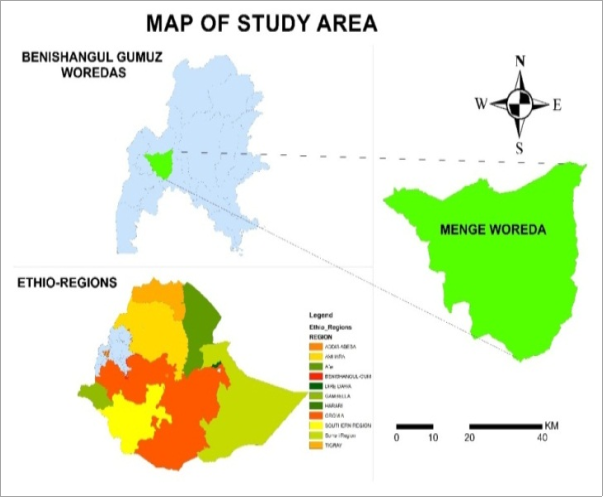
1.1. Location and Accessibility
The region is accessible via several routes connecting major cities within Ethiopia, typically requiring travel through the town of Asosa, the capital of the Benishagul Gumuz region. Accessibility can vary, particularly during the rainy season, when some roads may become difficult to traverse, underscoring the need for improved infrastructure to support mining activities. Geographically, the study area is bounded between 34030’51.18” E, 10015’48.44"N, and 34054’57.55” E, 10029'53.46"N.
1.2. Physiography
The Menge area, with its combination of flatlands, rugged valleys, towering ridges, and meandering rivers, offers not only breathtaking natural beauty but also a treasure trove of resources beneath its soil. This area is characterized by diverse topography, marked by rugged highlands, flat lands, and valleys typical of the Ethiopian Highlands. It is situated at an elevation ranging from 1,500 to over 2,400 meters above sea level, contributing to its complex hydrology and ecological zones.
2. Methodology
The methodology for assessing the geology and mineralization in the Menge area encompasses geological mapping, geochemical sampling, and remote sensing techniques. Geological mapping involves the systematic survey of rock types and structures, allowing for detailed lithological characterization and identification of potential mineral deposits. Geochemical sampling involves collecting soil, rock, and stream sediment samples for analysis to determine the concentration of key elements associated with mineralization; these samples undergo rigorous chemical assays to identify geochemical anomalies. Remote sensing technologies aid in recognizing large scale geological structures that may not be evident from ground surveys alone.
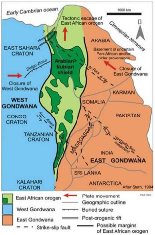
3. Geology and Tectonic Setting of the Study Area
3.1. Local Geology and Main Domain of the Study Area
The local geology of the Menge area is predominantly influenced by the Neo-proterozoic geological framework, comprising a combination of metamorphic and igneous rock formations. The region exhibits meta-sedimentary rocks associated with schist belts that are heavily mineralized with quartz veins, often rich in gold deposits
| [5] | Bowden, S., Gani, N. D., Alemu, T., O'Sullivan, P., Abebe, B., & Tadesse, K. (2020). Evolution of the Western Ethiopian Shield revealed through U-Pb geochronology, petro genesis, and geochemistry of syn- and post-tectonic intrusive rocks. *Precambrian Research*, 338, 105588. |
| [6] | National Geophysical Data Center. (2023, March 12). The East African Rift System: A geological phenomenon. National Oceanic and Atmospheric Administration.
https://www.ngdc.noaa.gov/eastafricanrift |
[5, 6]
. The primary geological domains identified in the area include the Birbir domain, characterized by volcanic rocks and associated sedimentary sequences, and the Baro domain, which is recognized for its metamorphosed intrusions.
In the Birbir domain, extensive hydrothermal processes have led to localized areas of mineralization, particularly within shear zones where gold deposits have been exploited for generations. Conversely, the Baro domain presents a different geological personality with its more complex structural features, including thrust faults and folds that create additional opportunities for mineral deposit formation
| [7] | Mogessie, A., Belete, K., & Hoinkes, G. (2000). Yubdo-Tulu Dimtu mafic-ultramafic belt, Alaskan-type intrusions in western Ethiopia: Its implication to the Arabian-Nubian Shield and tectonics of the Mozambique Belt. *Journal of African Earth Sciences*, 30(1), 62-79. |
| [8] | Nejad HT, Mumipour M, Kaboli R, Najib OA. Resistivity survey technique to explore groundwater in an arid region, southeast Iran. Res J Appl Sci. 2011; 1 (23): 3765-3766. |
[7, 8]
.
The following rocks are common rock types that are available in the study area.
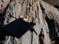
3.1.1. Meta-Diorite
These are medium- to coarse-grained, dark-colored rocks, with hornblende and plagioclase as their principal minerals. They form as a result of the metamorphism of basic igneous rocks
| [9] | Wolde MT, Mulualem A, Tadesse A (2021) Investigation of Ground Water Potential using Electrical Imaging Method in Assosa Town Benishangul Gumuz Region Western Ethiopia. J Geol Geophys. 10: 1003. |
| [10] | Allen A, Tadesse G. Geological setting and tectonic subdivision of the neo-proterozoic orogenic belt of Tuludimtu, western Ethiopia. J African Earth Sci. 2003: 1464-343. |
[9, 10]
. The meta-diorite unit observed in the study area exhibits a well-developed metamorphic foliation, characterized by slaty cleavage as shown in
Figure 3. It has a low to medium metamorphic grade and is primarily exposed in the study area by river cut.
3.1.2. Granite Unit
This lithological unit is a metamorphosed igneous rock formed under the influence of temperature and pressure. It is classified as a low-grade metamorphic rock and is typically light gray in color. In the study area, this unit does not exhibit any noticeable metamorphic fabrics, such as lineation or banding. It is exposed in road cuts and quarries within the Bane area (
Figure 4).
3.1.3. Meta-Sedimentary Unit
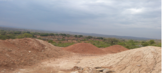
It is a meta-sedimentary rock formed by the action of tectonic forces on sedimentary rock (sandstone), representing sediment deposited during the Neo-proterozoic Era, about 600 million years ago. This unit covers a very small portion of the study area, found in flat land with a yellowish to pinkish weathered color. It is exposed at a quarry site, and texturally, it ranges from medium size to coarse-grained. Most of the rocks in the study area contain quartz veins. In the study area this lithological unit is exposed around Bane area (
Figure 5).
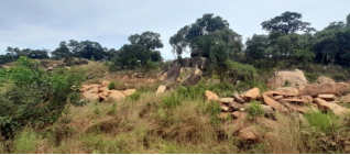
3.1.4. Quartzite Unit
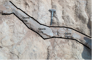
Quartz is primarily composed of SiO₂. Since quartz is stable over a wide range of pressures and temperatures, the metamorphism of quartz arenites results in the recrystallization of quartz, forming a hard rock with interlocking quartz crystals. This rock is called quartzite. It is a non-foliated metamorphic rock that typically has a whitish color. Quartzite is exposed in road cuts in the study area, mainly Bane- Shegoll provinces as shown in
Figure 6. In the study area this quartzite unit is mainly associated with gold mineralization and pyrite deposit as shown in the figure bellow.
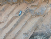
3.1.5. Columnar Basalt
The columnar structures in the study area are exposed in road cuts around Abora provinces. When thick basalt lava flows cool, they typically form hexagonal cracks known as columnar joints as shown in
Figure 7.
As shown in
Figure 8 the geology of the study area is mainly meta-sedimentary unit, meta-volcanic, and metamorphic unit.
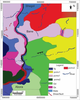
3.2. Regional Geology of the Study Area
The geology of Western Ethiopia is characterized by a complex and diverse geological history. The study area, situated in this region, lies within the context of the Precambrian basement rocks, which are divided into three major litho-structural domains based on lithology, style of deformation, and metamorphism
| [7] | Mogessie, A., Belete, K., & Hoinkes, G. (2000). Yubdo-Tulu Dimtu mafic-ultramafic belt, Alaskan-type intrusions in western Ethiopia: Its implication to the Arabian-Nubian Shield and tectonics of the Mozambique Belt. *Journal of African Earth Sciences*, 30(1), 62-79. |
[7]
. These domains are:
3.2.1. Central Low-Grade Domain
This domain lies between the western and eastern domains, forming a central belt that consists of high-grade gneisses. The majority of the Assosa-Kurmuk area falls within this domain. The gneisses are mainly of
migmatitic composition and are thought to be of Archean or early Proterozoic age
| [10] | Allen A, Tadesse G. Geological setting and tectonic subdivision of the neo-proterozoic orogenic belt of Tuludimtu, western Ethiopia. J African Earth Sci. 2003: 1464-343. |
| [11] | Ayalew, L., & Yirgu, G. (2010). The East African Rift: Tectonics and volcanic activity. Springer. |
[10, 11]
. They are primarily composed of middle to upper amphibolite facies and are exposed in the westernmost parts of the Assosa-Kurmuk area.
3.2.2. Eastern Domain
This region is marked by an extensive outcrop of felsic to mafic meta-volcanics intercalated with meta-sedimentary rocks. Additionally, there are occurrences of altered ultramafic bodies in the upper green schist to lower amphibolite facies. These rocks are considered to be late Proterozoic in age. The contact between these eastern rocks and the central low-grade domain is of tectonic origin
.
3.2.3. Western Domain
The western part of the study area contains high-grade gneisses and is characterized by more complex structural features, which are largely influenced by the presence of tectonic activity over long periods (
Figure 9).
The regional geology of Menge reflects its position within the Arabian-Nubian Shield, which is characterized by a tectonic history involving significant crustal deformations from the Pan-African orogeny. The area is predominantly underlain by low-grade volcanic and sedimentary successions, with granitic intrusions playing a vital role in the overall mineralization framework
| [9] | Wolde MT, Mulualem A, Tadesse A (2021) Investigation of Ground Water Potential using Electrical Imaging Method in Assosa Town Benishangul Gumuz Region Western Ethiopia. J Geol Geophys. 10: 1003. |
| [10] | Allen A, Tadesse G. Geological setting and tectonic subdivision of the neo-proterozoic orogenic belt of Tuludimtu, western Ethiopia. J African Earth Sci. 2003: 1464-343. |
[9, 10]
. Tectonically, the region has experienced several cycles of deformation that have shaped the current geological landscape. The structural features, including faults and shear zones, are crucial as they form pathways for mineralizing fluids, thereby creating concentrated deposits of economically significant minerals.
3.3. Tectonic Setting of the Study Area
The East African Rift System (EARS) is a major geological feature that extends from the Afar Triangle in the northeast to Mozambique in the south. It plays a critical role in shaping the tectonic and geological history of the region, including areas such as Ethiopia
| [13] | Woldemichael, B. W., Kimura, J., Dunkley, D. J., Tani, K., & Ohira, H. (2010). SHRIMP U–Pb zircon geochronology and Sr–Nd isotopic systematic of the Neoproterozoic Ghimbi-Nedjo mafic to intermediate intrusions of Western Ethiopia: International Journal of Earth Sciences, 99(6), 1773-1790. |
[13]
. The rift system results from the tectonic divergence between the African, Somali, and Arabian plates, which have been moving apart over millions of years. This ongoing divergence leads to the formation of extensional regimes that are characterized by a variety of geological phenomena, including faulting, volcanic activity, and the development of sedimentary basins.
The complex interactions within the EARS have shaped the landscape of Ethiopia, contributing to its unique topography and seismic activity. In the study area, tectonic influences are prominently observed through the presence of numerous fault lines meta- sedimentary and volcanic deposits.
4. Mineral Resources, Occurrences, and Potential Deposits of the of the Study Area
4.1. Gold Deposit
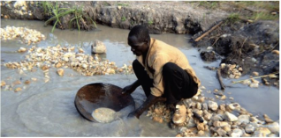
Today, gold remains the region's most sought-after resource, and the people of Menge have long been adept at extracting this precious metal. Locals still pan for gold in the streams, continuing a tradition that stretches back to ancient times. However, modern mining ventures have taken root, and several mines are now operational. Gold is one of the most abundant and economically significant minerals in the Menge area. The genesis of the gold mineralization reflects three key geotectonic events that have shaped the style of deposition.
The first type (I) is syngenetic with volcanogenic massive sulfide deposits, linked to calc-alkaline, island-arc, acidic volcanism, and dates back approximately 715 million years. During this period, gold was deposited as part of the volcanic processes.
The second type (II) is associated with a significant tectonic-metamorphic episode during collisional orogeny, which occurred around 650 million years ago. This event led to the remobilization of gold, which was subsequently precipitated in silica-barite and massive barite formations.
The third type (III) involves auriferous quartz veins that formed along first- and second-order shear zones, related to post collisional movements and retromorphism around 550 million years ago. In this case, gold was remobilized from earlier volcano-magmatic sequences and precipitated along structurally favorable sites, often influenced by tectonic stresses.
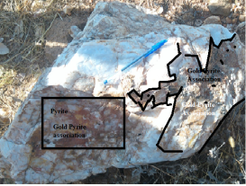
Generally, the region has several primary deposits that are indicative of high mineralization potential. Extensive alluvial gold deposits have been reported, which are often found along river beds and sedimentary formations. The major mines operating in this area, such as the Bane Shegoll mines, contribute significantly to Ethiopia's overall gold production, reflecting the area's potential as a significant gold-producing region. The study area is characterized by quartz veins, schist, and pegmatite rocks, which are all promising locations for gold deposits (
Figure 10).
4.2. Base Metal Deposits
The region also shows potential for base metal mineralization, particularly copper and zinc, which are associated with volcanic rocks and the alteration zones around fault structures. The mineralization is thought to be related to volcanic activity and the associated hydrothermal systems that have deposited these metals in veins and disseminated forms.
4.3. Other Mineralization
Other notably available mineralization in the study area includes chromite and tungsten deposits, particularly in the more metamorphose d areas of the Menge region. These deposits are typically associated with the granitic and gneissic rocks of the Arabian Nubian Shield. The study area lies in the southwestern part of the Ethiopian Plateau, which is characterized by a variety of geological features. The geological evolution of the study area is closely tied to the Mozambique belt and Arabian Nubian Shield. The stratigraphy of the study area is mainly dominated by a combination of Precambrian crystalline basement rocks, meta-sedimentary units, and tertiary meta-volcanic formations. The presence of shear zones is common, with many of these structures being sites of significant mineralization. These zones typically show evidence of strike-slip motion and are often associated with quartz vein deposits.
4.4. Potential for Future Exploration and Development
The Menge area holds substantial potential for future exploration and development in mineral resources. The combination of tectonic processes, geochemistry coupled with previous geological surveys, suggests many areas remain underexplored.
4.5. Factors Contributing to Exploration Potential
4.5.1. Unexplored Regions
Significant portions of the Menge area have not been fully explored, leaving possibilities for discovering new mineral deposits. Geological features such as previously unexplored fault systems and lesser visited areas could yield new mineral occurrences.
4.5.2. Geological and Geophysical Surveys
Recent advancements in geological and geophysical survey techniques enable more accurate assessments of mineral potential. These updated technologies can lead to more efficient exploration strategies, potentially decreasing costs and increasing the discovery rate of economically viable deposits.
5. Summary
The East African Rift System (EARS) is a major geological feature that extends from the Afar Triangle in the northeast to Mozambique in the south. It plays a critical role in shaping the tectonic and geological history of the region, including areas such as Ethiopia. The Menge area in Western Ethiopia showcases a remarkable geological setting marked by diverse mineralization and significant geochemical resources. Its complex history of tectonic evolution has produced various lithological units that contribute to its rich mineral potential. The integration of advanced geological mapping, geochemical analysis, and remote sensing techniques is essential for further exploring the region's mineral resources. The study area is predominantly underlain by low-grade meta-volcanic and meta-sedimentary successions, with granitic intrusions playing a vital role in the overall mineralization framework. This study tries to show a deeper understanding of the geology and mineralization of the area, underscoring its importance for both local economic development and broader geological studies in the Arabian-Nubian Shield.
Abbreviations
EARS | East African Rift System |
Author Contributions
Mesfin Tadesse Wolde is the sole author. The author read and approved the final manuscript.
Conflicts of Interest
The author declares that there is no conflict of interest.
References
| [1] |
Ethiopia's Untapped Gold Deposits - Africa Business Pages. (2024).
|
| [2] |
Geochemical Mapping: Technique or Art? – GeoScience World. (2017).
|
| [3] |
Grenne, T., Pedersen, R. B., Bjerkgård, T., Braathen, A., Selassie, M. G., & Worku, T, (2003), Neo-proterozoic evolution of Western Ethiopia: Igneous geochemistry, isotope systematics and U-Pb ages. *Geological Magazine*, 140(4), 373-395.
|
| [4] |
Johnson, P., Andresen, A., Collins, A. S., Fowler, A., Fritz, H., Ghebreab, W., & Kusky, T. (2011). Late Cryogenian–Ediacaran history of the Arabian-Nubian Shield: A review of depositional, plutonic, structural, and tectonic events in the closing stages of the northern East African Orogen. *Journal of African Earth Sciences*, 61(3), 167-232.
|
| [5] |
Bowden, S., Gani, N. D., Alemu, T., O'Sullivan, P., Abebe, B., & Tadesse, K. (2020). Evolution of the Western Ethiopian Shield revealed through U-Pb geochronology, petro genesis, and geochemistry of syn- and post-tectonic intrusive rocks. *Precambrian Research*, 338, 105588.
|
| [6] |
National Geophysical Data Center. (2023, March 12). The East African Rift System: A geological phenomenon. National Oceanic and Atmospheric Administration.
https://www.ngdc.noaa.gov/eastafricanrift
|
| [7] |
Mogessie, A., Belete, K., & Hoinkes, G. (2000). Yubdo-Tulu Dimtu mafic-ultramafic belt, Alaskan-type intrusions in western Ethiopia: Its implication to the Arabian-Nubian Shield and tectonics of the Mozambique Belt. *Journal of African Earth Sciences*, 30(1), 62-79.
|
| [8] |
Nejad HT, Mumipour M, Kaboli R, Najib OA. Resistivity survey technique to explore groundwater in an arid region, southeast Iran. Res J Appl Sci. 2011; 1 (23): 3765-3766.
|
| [9] |
Wolde MT, Mulualem A, Tadesse A (2021) Investigation of Ground Water Potential using Electrical Imaging Method in Assosa Town Benishangul Gumuz Region Western Ethiopia. J Geol Geophys. 10: 1003.
|
| [10] |
Allen A, Tadesse G. Geological setting and tectonic subdivision of the neo-proterozoic orogenic belt of Tuludimtu, western Ethiopia. J African Earth Sci. 2003: 1464-343.
|
| [11] |
Ayalew, L., & Yirgu, G. (2010). The East African Rift: Tectonics and volcanic activity. Springer.
|
| [12] |
Ebinger, C. J., & Sleep, N. H. (2002). Cenozoic rift-related volcanism in the East African Rift System. Geophysical Journal International, 149(3), 549-563.
https://doi.org/10.1046/j.1365-246X.2002.01632
|
| [13] |
Woldemichael, B. W., Kimura, J., Dunkley, D. J., Tani, K., & Ohira, H. (2010). SHRIMP U–Pb zircon geochronology and Sr–Nd isotopic systematic of the Neoproterozoic Ghimbi-Nedjo mafic to intermediate intrusions of Western Ethiopia: International Journal of Earth Sciences, 99(6), 1773-1790.
|
Cite This Article
-
-
@article{10.11648/j.sdenv.20260101.12,
  author = {Mesfin Tadesse Wolde},
  title = {Geology, Mineralization and Tectonic Evolution of the Menge Area, Western Part of Ethiopia},
  journal = {Science Discovery Environment},
  volume = {1},
  number = {1},
  pages = {19-25},
  doi = {10.11648/j.sdenv.20260101.12},
  url = {https://doi.org/10.11648/j.sdenv.20260101.12},
  eprint = {https://article.sciencepublishinggroup.com/pdf/10.11648.j.sdenv.20260101.12},
  abstract = {In today’s Ethiopia, gold is the country’s largest hard currency earner. While Ethiopia also exports other valuable minerals such as sapphire, opal, tantalum, emerald, gemstones, and marble, gold has become the focal point for the country's economic transformation. The Menge area, nestled in the Benishangul Gumuz region of Western Ethiopia, is part of the broader Arabian-Nubian Shield, a geological formation renowned for its mineral wealth, particularly gold and base metals. The Menge area in Western Ethiopia presents a complex geological landscape characterized by diverse mineralization and significant geochemical resources. The regional geology of Menge reflects its position within the Arabian-Nubian Shield, which is characterized by a tectonic history involving significant crustal deformations from the Pan-African orogeny. The area is predominantly underlain by low-grade volcanic and sedimentary successions, with granitic intrusions playing a vital role in the overall mineralization framework. This paper synthesizes existing literature on the geology, mineralization processes, and geochemistry of the region, emphasizing the local geological domains, their mineral potential, and the overall tectonic setting. The findings are crucial for guiding future exploration and exploitation endeavors in the area, with implications for local and national economic development. This paper encapsulates the geological, mineralogical, and geochemical facets of the Menge area to provide an informative foundation about the mineral resources of the study area.},
 year = {2026}
}
 Copy
|
Copy
|
 Download
-
TY  - JOUR
T1  - Geology, Mineralization and Tectonic Evolution of the Menge Area, Western Part of Ethiopia
AU  - Mesfin Tadesse Wolde
Y1  - 2026/01/31
PY  - 2026
N1  - https://doi.org/10.11648/j.sdenv.20260101.12
DO  - 10.11648/j.sdenv.20260101.12
T2  - Science Discovery Environment
JF  - Science Discovery Environment
JO  - Science Discovery Environment
SP  - 19
EP  - 25
PB  - Science Publishing Group
UR  - https://doi.org/10.11648/j.sdenv.20260101.12
AB  - In today’s Ethiopia, gold is the country’s largest hard currency earner. While Ethiopia also exports other valuable minerals such as sapphire, opal, tantalum, emerald, gemstones, and marble, gold has become the focal point for the country's economic transformation. The Menge area, nestled in the Benishangul Gumuz region of Western Ethiopia, is part of the broader Arabian-Nubian Shield, a geological formation renowned for its mineral wealth, particularly gold and base metals. The Menge area in Western Ethiopia presents a complex geological landscape characterized by diverse mineralization and significant geochemical resources. The regional geology of Menge reflects its position within the Arabian-Nubian Shield, which is characterized by a tectonic history involving significant crustal deformations from the Pan-African orogeny. The area is predominantly underlain by low-grade volcanic and sedimentary successions, with granitic intrusions playing a vital role in the overall mineralization framework. This paper synthesizes existing literature on the geology, mineralization processes, and geochemistry of the region, emphasizing the local geological domains, their mineral potential, and the overall tectonic setting. The findings are crucial for guiding future exploration and exploitation endeavors in the area, with implications for local and national economic development. This paper encapsulates the geological, mineralogical, and geochemical facets of the Menge area to provide an informative foundation about the mineral resources of the study area.
VL  - 1
IS  - 1
ER  -
Copy
|
Download