Abstract
This study fills a unique gap in the integration of health planning and climate adaptation in places of compounded environmental and socio-economic stressors. It presents the integrated health planning framework for climate zones (IHPF-CZ), which aims to systematically connect climate adaptation and resilience strategies to public health and health equity impacts. The IHPF-CZ was tested empirically during a 12-month multi-modal study in varying climates and socio-economic levels in Saudi Arabia, Kuwait, and Yemen. The IHPF-CZ merges three interdependent components: hybrid gray–green–blue (3-H) infrastructure, digital equity, and adaptive governance. The methodology includes IoT (Internet of Things) sensor networks, AI (artificial intelligence) predictive modeling, health surveillance (via the International Classification of Diseases 10th revision), satellite remote sensing, and blockchain/resource allocation. This integration allows for real-time control, responsive governance, and adaptive planning in resource- and climate-stressed environments. As substantial evidence shows, there are major co-benefits in health, climate, and resource efficiency. Flood occurrences were reduced by 40.1% in areas prone to flooding. In arid cities, average urban ambient temperatures decreased by 5.1°C. There was a 25% reduction in heat-related illnesses, along with declines in emergency visits and community heat stress. In addition, agricultural water use efficiency increased by 30.6%, and equitable resource distribution improved, as shown by a decrease in the Gini coefficient from 0.42 to 0.19. These findings show that when climate adaptation is designed with a health and equity focus instead of simply treating it as a sectoral intervention, it provides significant and measurable benefits to society. The most notable finding of this study is that the IHPF-CZ serves as a proof of concept for a data-driven and scalable model that can achieve the interconnected goals of climate resilience, public health, and sustainable development, particularly in fragile, resource-depleted regions.
Keywords
Health-climate co-benefits Assessment, IoT-blockchain for Resource Equity, Equity-centered Climate Governance,
Smart Urban Climate Adaptation, Hybrid Green-gray Infrastructure, Climate-resilient Health Systems
1. Introduction
The rapid development of climate change is an environmental issue and a major factor endangering public health across the globe
| [11] | Intergovernmental Panel on Climate Change. (2022). Climate change 2022: Impacts, adaptation and vulnerability. Cambridge University Press. |
| [24] | Smith, J., et al. (2022). Integrating health and climate resilience. Nature Sustainability, 5(3), 210-225.
https://doi.org/10.1038/s41893-022-00859-y |
| [28] | World Health Organization. (2021). Urban health in a changing climate. https://www.who.int |
[11, 24, 28]
. Extremities weather events, such as massive floods, droughts, and heat waves, are becoming more severe and occurring more often. This poses a significant threat to ecological systems, infrastructure, and social systems. Together, these systems make a complex of interrelated system problem known as the climate health nexus
. Adaptation does not work in these siloed systems. While rapid progress has been made in certain fields, such as combining green technologies to cool down urban areas and using gray infrastructure to manage floods, the gaps remain alarming
| [8] | Depietri, Y., Renaud, F. G., & Kallis, G. (2017). Integrating the grey, green, and blue in cities: Nature-based solutions for climate change adaptation, and risk reduction. Sustainability Science, 12(6), 941-956. https://doi.org/10.1007/s11625-017-0459-6 |
[8]
. There is no interrelated approach to protecting health that is also socially, physically, and digitally focused in the most vulnerable communities. When operating models are separated, crucial interrelated issues are solved, and the solutions will lack comprehensiveness. An example of this is when engineered infrastructure reduces risk in a certain way but does not reduce the risk in other areas, such as health, equity, and social systems. Nature-based solutions could provide ecological resilience but may not be monitored or scaled effectively.
The global shift to digital technology, such as the Internet of Things (IoT), Artificial Intelligence (AI), and blockchain, pioneers new possibilities for real-time updates, analytics, and accountability tracking within governing processes. The use of these technologies in integrated climate and health planning, especially in resource-scarce or post-conflict situations, remains unexplored, and most likely due to cost, complexity, and implementation barriers
.
The disconnect between technology, equitable governance, and health benefits remains a critical in research and practice gap
. This study attempts to close that gap by proposing, operationalizing, and empirically validating the integrated health-planning framework for climate zones (IHPF-CZ). This particular transdisciplinary model is based on the synergistic integration of three critical and interdependent pillars: (1) hybrid infrastructure, i.e., the combination of traditional ‘grey’ and ‘green/blue’ nature-based solutions; (2) digital innovation, i.e. the use of IoT, AI, and blockchain technologies for optimal data-driven decision and resource management; and (3) equity-ensuring governance, i.e., the integration of participatory processes to empower community ownership and control, and thus achieve sustainable closure of the digital divide. Using socio-ecological-technological systems (SETS) theory, the IHPF-CZ is more than a concept; it is a potentially replicable model: the resilient hybrid multi-component ecosystem (RHMCE).
The main purpose of this study is to determine whether using all these pillars together will be more advantageous and fair in achieving climate and health resilience than using any one of them and staying within a single sector. We undertook one of the most challenging 12-month field studies in one of the most challenging and diverse climatic and socio-economic regions of the world, ranging from the arid cities of Saudi Arabia and Kuwait to post-conflict Yemen affected by flood. Using a sophisticated multimodal approach that includes IoT sensors, AI-based predictive modeling, and blockchain for optimized resource distribution, along with validated health and equity metrics, our framework created a detailed, high-quality dataset that allows for the framework’s measurement and evaluation. This study contributes to the growing body of knowledge in several ways. It defines and operationalizes an integrated climate and health resilience framework, and advances conceptual thinking. For the first time, it demonstrates the operational viability and effectiveness of low-cost digital tools in fragile environments from difficult setting. Finally, it provides a unique framework for measuring the benefits of integrated approaches, particularly the health benefits that result from a reduction in climate-related dangers such as temperature and flooding.
First, this work assigns a scalable, data-oriented paradigm to policymakers and practitioners. It has the potential to reshape climate adaptations from a disjointed concern into a consolidated approach toward achieving of health equity and sustainable development in a world fraught with challenges.
1.1. Research Question
Can an integrated framework that synergizes hybrid infrastructure, digital innovation, and equity-centered governance make a substantial difference in climate resilience and health improvements in disadvantaged areas?
1.2. Hypothesis
The IHPF-CZ suggests that the integrated use of hybrid infrastructures, digital tools, and equitable governance, in contrast to other infrastructures, will have a significantly greater and more just impact on the reduction of climate hazards and improving of resource use and public health.
1.3. Objective
To develop, test, and empirically validate the IHPF-CZ as a replicable, transdisciplinary model for climate and health resilience, along with the assessment of its co-benefits in a wide range of climatic and socio-economic conditions.
1.4. Methodological Analysis and the Research Gap
The research approach reveals excellent triangulation by means of multiple data sources; however, sample representation has some limitations, which is restricted by the piloting sites' relatively small number and the absence of densely populated and conflict-affected areas. On the other hand, the intervention duration of this research is only 12-months, which is inadequate for identifying the long-run associations between climatic factors and health systems' response and adaptation. Data sources are predominantly based on technology-based instruments, which might neglect some non-formal health aspects and adaptations. Extremities weather events, such as massive floods, droughts, and heat waves, are becoming more severe and occurring more often
| [11] | Intergovernmental Panel on Climate Change. (2022). Climate change 2022: Impacts, adaptation and vulnerability. Cambridge University Press. |
| [28] | World Health Organization. (2021). Urban health in a changing climate. https://www.who.int |
[11, 28]
.
Research gap:
The effectiveness through scaled/validated causality pathways of a combination of health outcomes, governance dynamics, and cost-effectiveness across a variety of socio-political settings can and should be proved by means of a multi-country quasi-experimental study or randomized control trial.
2. Literature Review
The relationship between urban health, climate resilience, and climate impacts is increasingly recognized as an issue of complex adaptive systems, where climate risk, infrastructure, governance, and population health systems are nonlinear and interdependently affect each other of complex adaptive systems (CAS) and, thus, not amenable to linear problem-resolution strategies. Cities experiencing extreme climatic conditions have nonlinear relationships between the effects of climatic risks, the condition of infrastructure, the structure of governance, and the resultant health outcomes for the population, such that the risk challenges cannot be dealt with in the framework of planning individual systems such as infrastructure or health, or even the environment
| [9] | Dong, X., Guo, H., & Zeng, S. (2017). Enhancing future resilience in urban drainage systems: Green versus gray infrastructure. Water Research, 124, 280-289.
https://doi.org/10.1016/j.watres.2017.07.038 |
| [22] | Sharifi, A. (2023). The resilience of urban social-ecological-technological systems (SETS): A review. Sustainable Cities and Society, 89, 104321.
https://doi.org/10.1016/j.scs.2023.104321 |
[9, 22]
.
The socio-ecological-technological systems (SETS) framework has emerged as a paradigm for understanding resilience in cities from CAS theory. SETS views cities as tightly coupled systems, where, ecosystems, technology, and social systems interact through covolution
. Rather, within this theoretical context, infrastructure is conceptualized neither as a separable physical system entity nor as a hybrid system but instead as one that is governed and controlled by technology and ecology. The essential resilience properties of adaptability, redundancy, equity, learning, and multi-functionality are viewed as properties of a system, not as isolatable system properties.
The foundations of climate–health within Complex Adaptive Systems (CAS) and Socio-Ecological and Technological Systems (SETS) theories provide the most relevant underpinning for the Integrated Health Planning Framework for Climate Zones (IHPF-CZ) planning framework climate zone (IHPF-CZ). Instead of aggregating disparate sector interventions, the tool models the interactions among climate risk factors, hybrid infrastructure systems, digital technologies, and health outcomes. The theoretical foundations described above represent a starting premise toward a systemic adaptation strategy for the challenges posed by extreme urbanization under a climate change scenario in arid, flood-vulnerable, and state-fragile cities. Historically, urban climate adaptation has relied on segregated infrastructural paradigms. Gray infrastructure, such as dams, levees, sea walls, and drainage tunnels, is designed for the engineered control of climatic hazards such as flooding and storm surges
| [8] | Depietri, Y., Renaud, F. G., & Kallis, G. (2017). Integrating the grey, green, and blue in cities: Nature-based solutions for climate change adaptation, and risk reduction. Sustainability Science, 12(6), 941-956. https://doi.org/10.1007/s11625-017-0459-6 |
[8]
. While these systems may offer some protection in the short term, they often merely displace risk in a spatial dimension, lock cities into hard-to-alter path dependencies, and neglect long-term ecological degradation and social vulnerability. Gray-only systems are usually underperforming under non-stationary climate conditions
. Particularly in cases where extreme events exceed initial design assumptions
.
By contrast, green and blue infrastructure—urban forests, wetlands, parks, and bioswales, has recently gained prominence for its potential to regulate temperature, attenuate floods, and have co-benefits with respect to physical and mental health
. This is because green infrastructure is often implemented as an amenity-driven add-on rather than a core urban service. Such interventions tend to be under-scaled, weakly maintained, and poorly integrated into critical systems such as drainage, energy, and health infrastructures.
The major drawback of the two paradigms is the separation that is involved. Gray-green approaches that are fragmented neglect the synergy effects that can be leveraged to improve resilience, efficiency, and equity. Public health institutions, such as the World Health Organization, have pointed out that the separated approach is inefficient in its ability to address the risks associated with systemic challenges such as the lack of water, heat, and diseases
| [20] | Schwerdtle, P. N., et al. (2024). Climate change-resilient health facilities in low- and middle-income countries: A scoping review. Environmental Research Letters, 19, 034001.
https://doi.org/10.1088/1748-9326/ad1e3b |
[20]
.
The emergence of hybrid infrastructure and digital innovation has been noted as a promising approach .
Their suitability in arid, conflict-ridden, and fragile settings has not yet been investigated | [12] | Islam, F. A. S., et al. (2025). Artificial intelligence-driven hybrid renewable and waste-to-energy systems for climate-resilient and equitable urban infrastructure in the Global South. Journal of Engineering Research. Advance online publication. |
[12]
. There has been a growing need to propose and explore the potential of hybrid systems of blue, green, and gray infrastructure to overcome these limitations. Empirical work and optimization studies have shown that coupled systems are more effective than single-mode systems in terms of flood storage, peak flow mitigation, flexibility, and cost
| [18] | Li, Z., et al. (2021). Land surface temperature algorithms: A comparative analysis. Remote Sensing of Environment, 263, 112555. https://doi.org/10.1016/j.rse.2021.112555 |
| [27] | Wang, M., et al. (2023). Assessing and optimizing the hydrological performance of grey-green infrastructure systems under climate change. Water Research, 230, 119504.
https://doi.org/10.1016/j.watres.2022.119504 |
| [29] | Zhou, S., et al. (2025). Multi-stage optimization framework for synergetic grey-green infrastructure under long-term climate variability. Water Research. Advance online publication. |
[18, 27, 29]
. Hybrid systems open up more resilience options to urban settings and provide adaptive capacities during various stages of climate events
.
“Parallel transformation” refers to the digital enhancement of hybrid infrastructure. The internet of things, artificial intelligence, and the concept of a “digital twin” have reached the stage where real-time monitoring and predictive and adaptive control can be achieved for urban infrastructure
| [15] | Kaluarachchi, Y. (2020). Potential advantages in combining smart and green infrastructure over silo approaches for future cities. Frontiers of Engineering Management, 7(2), 195-207. https://doi.org/10.1007/s42524-020-0113-4 |
[15]
. Digitally based hybrid infrastructures facilitate the ‘safe-to-fail’ paradigm, and their ability to absorb a shock condition is maintained with the bare essentials. Multi-objective optimization models indicate the possibility of optimizing the gray-green paradigm for resilience, cost, and performance under uncertain climatic futures
| [27] | Wang, M., et al. (2023). Assessing and optimizing the hydrological performance of grey-green infrastructure systems under climate change. Water Research, 230, 119504.
https://doi.org/10.1016/j.watres.2022.119504 |
| [29] | Zhou, S., et al. (2025). Multi-stage optimization framework for synergetic grey-green infrastructure under long-term climate variability. Water Research. Advance online publication. |
[27, 29]
.
However, despite these achievements, however, the dissemination of digitally improved hybrid systems remains unequal. While less developed countries, especially in regions experiencing conflicts and being vulnerable to climate change, have not been adequately studied and funded, according to Allam et al. (2022) and Schwerdtle et al. (2024)
. The main documented applications can still be found in rich or better-off cities, with low-income, conflict-prone, or climate-susceptible areas still not well-represented
| [21] | Seidu, S., et al. (2025). A systematic review of green infrastructure and ecosystem-based technologies for climate resilience. Environmental Research Letters. Advance online publication. |
[21]
. High investment barriers, a lack of data, and structural factors contribute to a widening gap between innovation in technology and access. While digital technologies such as blockchain exist with huge potential in promoting resource allocation and accountability, their suitability in arid, conflict-ridden, and fragile settings has not yet been investigated
| [12] | Islam, F. A. S., et al. (2025). Artificial intelligence-driven hybrid renewable and waste-to-energy systems for climate-resilient and equitable urban infrastructure in the Global South. Journal of Engineering Research. Advance online publication. |
[12]
. Although attention to the topic of hybrid infrastructure is growing, direct linkages between health or health outcome metrics have yet to be explicitly included. A good portion of the current literature has emphasized hydrological function, cost-effectiveness, or more general notions of sustainability, assuming the provision of health benefits for secondary purposes
. While the literature has demonstrated the ability of green-blue infrastructure to lessen heat-related stress, flood-related injuries, and mental health benefits, such aspects have yet to be considered for a direct primary purpose.
In addition to these factors, geographic concentration narrows the scope of the literature. Generally, most empirical work is constrained to East Asia, Europe, or North America. This restricts the generalizability of the results to hyper-arid and multi-hazard areas with instability in the political systems of the Middle East and North Africa. This is because these areas either have compound risks due to high temperatures, water shortages, rapid growth in urban areas, and a constrained environment or lack comprehensive approaches toward climate and health resilience.
The area of health system research is not exempt from the aforementioned challenges. While the literature on climate adaptation and public health has grown, the body of work is still unrefined, and we are still left with an understudied area that lacks empirical frameworks which operationalize the interaction between hybrid infrastructures, digital frameworks, health-centered governance, and other systems in a single model. Despite the existence of international guidelines on the establishment of climate-resilient and low-carbon health systems, these approaches focus on infrastructure, digital systems, and community management as parallel fields of application
| [14] | Joseph, H. A., et al. (2025). A flexible framework for urgent public health climate action. American Journal of Public Health. Advance online publication. |
| [20] | Schwerdtle, P. N., et al. (2024). Climate change-resilient health facilities in low- and middle-income countries: A scoping review. Environmental Research Letters, 19, 034001.
https://doi.org/10.1088/1748-9326/ad1e3b |
[14, 20]
. Few studies have combined these sectors to achieve a specific goal of improving climate-health performance.
Synthesis of the critical gaps motivating the IHPF:
Three closely connected gaps have been identified in the literature. First, there is an integration gap, in which hybrid blue, green, and gray infrastructures are essentially maximized for hydrology and financial viability, while the use of data-driven governance frameworks and health-related metrics in the system are poorly developed or even not used at all. Second, there has been an evident justice gap, inasmuch as the vast majority of the empirical studies have involved highly developed countries, while less developed countries, especially in regions experiencing conflicts and being vulnerable to climate change, have not been adequately studied and funded, according to Allam et al. (2022) and Schwerdtle et al. (2024). Third, a metrics gap exists that prevents learning and replication in this area because current resilience frameworks do are not typically operationalize correlations between design variables (such as cool pavement and urban greening) and specific health outcomes metrics (such as heat-associated morbidity).
These gaps indicate the need to develop an integrated health planning framework for climate zones, IHPF-CZ, and the resilient hybrid multi-component ecosystem, commonly abbreviated as RHMCE. This framework contributes to bridging the aforementioned gaps by combining hybrid infrastructure, digital innovation, and health-governing principles with health indicators of the impacts of climate on health.
3. Methodology
For this purpose, the present study employed a sequential mixed-methods approach designed to validate the the results and operationalization of the IHPF-CZ framework on the gradient of climatic conditions. The overall reasoning for the methodology relates to the implementation of the joint interventions (IHPF-CZ/RHMCE) to determine the interventions’s various effects.
3.1. Study Design & Site Selection
A quasi-experimental and pre-post intervention design with the implementation phase of 12-months (January to December, 2024) was employed. Three different sites were chosen to determine the flexibility of the proposed model:
Arid Urban Zones (Riyadh, Saudi Arabia; Kuwait City, Kuwait): Assessing the effectiveness of thermal regulation and resource efficiency projects. Flood-prone, resource-constrained region (Marib, Yemen): Assess low-cost approaches to flood mitigation and equitable-governance strategies for a resource-scarce. The retrospective time period considered for comparisons relates to a three-year period from 2021 to 2023.
Causality determination: While the current quasi-experimental pre-post design is quite practical, it is rather difficult to ascertain the individual impact of the interconnected pillars (hybrid infrastructure, digital innovation, governance). Future iterations of this design should use a staggered implementation (e.g., stepped-wedge) or a component-ablation approach to decisively evaluate the core hypothesis, which is that integration is superior to siloed approaches. This enables the assignment of causality to specific elements of the proposed framework.
3.2. Data Acquisition and Instrumentation
A high-fidelity multi-source data integration infrastructure has been created to offer traceability and rigor.
3.2.1. Microclimate Monitoring
To achieve this, data from 120 IoT sensor nodes, with an accuracy of ±0.2°C for temperature measurement and ±2% for the measurement of relative humidity, using the Sensirion SHT31-D model, were used to measurE the ambient temperature and relative humidity in 5-minutes intervals, thus satisfying the first objective directly by supplying data for the evaluation of the interventions of the water system. The efficiency: Ultrasonic smart water meters (Kamstrup MULTICAL® 21) measure and record water flow volumes to support the calculation of water-use efficiency (WUE) flow volumes. The data allowed for the calculation of water-use efficiency (WUE, crop yield in kg per water m³) and fulfilled Objective 2.
3.2.2. Health Surveillance
Morbidity related to heat was monitored through the World Health Organization’s heat-health surveillance system. Morbidity cases that were medically validated and classified according to the International Classification of Diseases 10th Revision (ICD-10; T67) codes were used. The reliability of the coders was checked to ensure accuracy (Cohen’s κ = 0.88). This approach automatically links climate hazard reduction with health impacts.
3.2.3. Flood Mapping and Social Equity Evaluation
The flood risk zones were identified using Sentinel-2 satellite imagery and ground rutting, resulting in a very reliable flood map (ICC = 0.91). Indicators measuring perception toward equity and governance were evaluated using reliable 5-point Likert scale with a Cronbach’s alpha level of 0.84, and Objective 3 was met. Flood risk zones were identified using Sentinel-2 satellite imagery and ground rutting, with additional analysis supported by Google Earth Engine
.
3.3. Ramirez Estrada’S Frames of Intervention
The practical application of the IHPF-CZ within the framework of the (RHMCE) operationalized its implementation.
3.3.1. Biophysical Interventions (Table 1) The precise spatial footprint included IoT sensors (concentrically up to 75 m from the interventions to quantify spillover gradients), 5,200 m2 of high-albedo pavement, 1,800 m2 of green roofs, and 3 modular dams (total capacity 450 m3).
1) Cool roofing materials/pavements: These must have a minimum solar reflectance value or albedo value of 0.7.
2) Green roofs: Installed with a substrate thickness of 15 cm for thermal and stormwater retention purposes. Modular, IoT-Sensor-equipped dams (Marib): Used for flood management.
3) Intervention description: The requires to specify the total area covered by the cool surfaces, the total area of the green surfaces, the total number of green installations and their specifications, the total capacity of the dams, a map of the sensors to show their spatial distribution, and a description of the sensors to assess the spatial distribution of the interventions and the spillover effects of the interventions.
3.3.2. Digital and Governance Interventions (Tables 2 and 3) 1)
AI Predictive system: An LSTM neural network, which was trained using ERA5 climate reanalysis data and IoT real-time data, predicted flood and heat-related risks with a good AUC of 0.92. It was linked to automatic actions such as smart irrigation cutoff and drainage opening
.
2) Blockchain for resource equity: This utilized a hyperledger fabric-based approach where water resource management was enabled through smart contracts.
In Marib, agricultural WUE was measured on 12 sorghum plots (each 0.5 ha), and yields were validated by harvest weight; smart contracts allocated water based on soil moisture and equity rules, reducing Gini from 0.42 to 0.19. Please consider the following adjustments and additions to the entire proposal:
1) Blockchain implementation: The contribution to equity (Gini reduction) needs to be aligned with some of the blockchain aspects. Perhaps one subsection could describe the network type, smart contracts the architecture regarding water allocation, data oracle(s), and why the system is better than a traditional database in terms of transparency and fair distribution.
2) AI Model specification: The high AUC (0.92) needs more detail: what are the risk labels (the set thresholds), is there a temporally/spatially blocked data split to avoid leakage, how does it perform versus simpler baselines (logistic regression, for instance), and what are the quantiles, if any, for the expected/actual distribution of the predicted values, and how predictively reliable is it for the event?
3) Water digital twins: Relating the IoT-AI pipeline with known digital twin frameworks, such as CAUCCES, would be beneficial in evaluating forecasting accuracy, optimization, and cybersecurity within a systems-integration approach.
4) LSTM risk labels were binary (flood/heat > 90th percentile), with data split temporally (2018-2022 train, 2023 test); it outperformed logistic regression (AUC 0.78) and achieved a Brier score 0.11 with detailed confusion matrices in supplementary materials.
3.3.3. Participatory Governance
Community resilience committees (CRCs) have been established to co-prioritize interventions and validate data, bringing the element of equity into the implementation strategy.
3.4. Analytical and Validation Methods
For each outcome, certain methods were used to measure the degree of change and determine the causal relationship between the expected and actual outcomes:
1) Controls and confounding: For the dramatic changes to be noted of flood frequency (40.1% reductions) and urban temperature (5.1°C reductions), it has to be detailed that changes are due to the intervention and not the inter-annual climatic variability. For such enunciations, the models should be well defined. In the analysis of floods, variables such as rainfall intensity and antecedent conditions should be factored. On the other hand, heat outcome models should adjust factors relating to the weather at the time, e.g., a degree-day breakdown for the baseline and the time the of intervention.
2) Statistical rigor: To fully assess model validity, it is highly encouraged that future revisions be accompanied by some of the more significant diagnostics (for example, the Poisson overdispersion tests and the normality checks), and these should be alongside the reports of the confidence intervals for effect sizes, and these are also required in the case of the sensitivity analysis (also known as the placebo test). To assess the validity of the claims made by their p-values. The inclusions of annual rainfall totals and heat degree days were used to account for climatic variability, as well as the sensitivity analysis, which to a certain extent confirmed the variability of every element in weather and every other element in the baseline against the model.
3) Flood mitigation: The change in the frequency of flood events was tested for significance using Poisson regression, while the change in the duration of the events was tested using the two-sample.
4) The magnitude of temperature variations and associated health outcomes was assessed by examining the difference in thermal indices and HRM rates. WUE was evaluated by applying linear regression to daily ratios of agricultural yield relative to water consumption, allowing for a robust quantification of efficiency gains over time.
5)
Geospatial and qualitative analysis: In the GIS-based raster analysis, integrated (LST) and NDVI layers were mapped onto vulnerability. Thematic analysis of workshop transcripts, using NVivo, was used to describe community priorities; inter-coder reliability was calculated at κ = 0.82
.
3.5. Ethical Considerations
This protocol had full IRB approval (Ref: NRC/AE/2025/014). All data were anonymized via a triple-coding process. A co-designed benefit-sharing agreement preceded the intervention to protect community resources. Informed consent was in writing with explicit rights to withdraw. This ethical framework was integral to every community-engaged step of the methodology.
The 2025 reference reflects the councils annual renewal cycle for the multi-year studies. Full IRB approval (NRC/AE/2025/014) was obtained prospectively obtained in December 2023 prior to any data collection.
3.6. Ethical Approval
The research ethics for Amran University and the National Research Council of Yemen have been followed for this research. Formal ethical clearance was obtained prior to data collection (Reference No.: NRC/AE/2025/014). The research did not involve direct experimentation with people or with living creatures. All activities followed the ethical guidelines for research at the institution and the country as a whole.
3.7. Consent to Participate
Prior to their inclusion in the research, all participants were informed of the study's objective and its scope and confidentiality measures. Informed consent was documented in writing for individual participants. They were told that they could withdraw from the study at any time, with no penalty.
3.8. Consent to Publish
All participants consented to the use of anonymized data and the publication of research findings. No identifiable personal information is included in the manuscript. The author is fully responsible for the accuracy of the data and the manner in which the data is represented.
3.9. Declaration of Generative AI and AI-assisted Technologies in the Writing Process
The authors of this manuscript utilized the AI tool ChatGPT to rephrase a few sentences in the document to improve the clarity and readability of the manuscript. Thereafter, the authors thoroughly analyzed, edited, and polished all outputs for precision, consistency, and adherence to the goals of the research. The authors declare that they fully assume responsibility for the integrity, originality, and final content of the publication.
Figure 1. A methodological framework for hybrid climate resilience that integrates interactive workshops, IoT networks, and AI-driven climate data. In arid and rain-affected areas, the design balances gray-green infrastructure with equity-focused governance, emphasizing transdisciplinary approaches.
4. Results and Findings: Empirical Validation of the IHPF-CZ
The integrated health planning framework for climate zones (IHPF-CZ) was empirically verified for its efficacy through a 12-month field test, conducted from January to December 2024, on three pilot sites with diverse climatic and socioeconomic profiles. The evaluation process involved the use of standardized quantitative and qualitative evaluation criteria, with well-defined baselines and rigorous statistical validation, and the outcomes are generated for four integral performance areas, with the cumulative evidence from the study delineated in four tables suitable for a scientific publication.
4.1. Climate Hazard Mitigation and Infrastructure Performance
The application of IoT-powered modular drainage systems and AI analytics to predictive modeling has led to dramatic reductions in flood vulnerability in the flood-vulnerable region of Marib, Yemen,. Flood instances were distinguished as instances where water accumulation exceeded 15 cm and lasted longer than 2 h and were validated through sensor logs and flood resilience committee reports. Against the 2021-2023 baseline, there has been a 40.1% annually relative reduction in flood instances and a 56.3% relative reduction in average flood duration. Additionally, there has been great predictive power with an AUC measure of 0.92. In the monsoon season, 78% of flood instances could be averted through system activation.
Under the arid conditions prevailing in Riyadh and Kuwait City, the high-albedo pavement and green roofs resulted in measurable microclimatic improvements. The average ambient air temperature decreased by 5.1°C during the critical hours of the day when compared with the control areas, and the surface temperature decreased by 18.6°C. Vegetation health improved, with the NDVI enhancing by 89%. Based on spatial analysis, the range of the influence was 50–75 meters beyond the physical edges around the intervention areas.
The temperature attribution that used energy balance modeling estimated a 60% reduction from albedo and 30% evapotranspiration; UTCI decreased by 6.2°C, consistent with synoptic data showing comparable air masses in baseline/intervention periods.
Table 1. Climate hazard mitigation and infrastructure performance.
Outcome Indicator | Site | Baseline Condition | Post-intervention (2024) | Magnitude of Change | Statistical Test and Validation Method. |
Flood events per year | Marib, Yemen | 15.2/year | 9.1/year | −40.1% | Poisson regression, p < 0.01 |
Mean flood duration | 4.8 hrsMarib, Yemen | 4.8 hrs | 2.1 hours | -56.3% | Two-sample t-test, p < 0.001 |
Peak ambient air temperature (°C) | Riyadh, Kuwait City | 43.5°C | 38.4°C | −5.1°C | Repeated measures comparison |
Surface temperature (°C) | Riyadh-Kuwait City | 58.1°C | 39.5°C | -18.6°C | Infrared validation |
Vegetation performance (NDVI) | Riyadh, Kuwait City | 0.18 | 0.34 | +89% | Observation by remote sensing |
*Data sources: IoT sensor network (Sensirion SHT31-D, accuracy ±0.2°C) and validated CRC incident reports. Inter-rater reliability κ = 0.88. |
Table 1 combines all the indicators related to the mitigation of climatic hazards and the performance of the infrastructure, such as the metrics related to flooding, with their respective baselines, intervention, and validation.
Figure 2. The figures use clean lines/marks to present the difference between the baseline and the intervention of 2024 on a reduced flooding index, and urban temperature index. It also emphasizes a significant improvement in vegetation condition (NDVI) and clearly establishes the effectiveness of climate hazard mitigation.
4.2. Health Outcomes and Resource Efficiency
A decrease in the level of climate exposures resulted in identifiable gains in public health. The morbidity attributable to heat reduced by 25% from summer 2023 to summer 2024. While the number of emergency department visits related to heat stress reduced by 29.9%, the community-generated index of heat stress reduced by 33.3%.
The results of the spatial correlation analysis revealed a roboust link between the regions where the level of temperature mitigation was applied and the enhanced health outcomes (the Spearman’s rho value 0.73. Groups most sensitive to climate would observe a relative risk reduction of 38%).
Concomitantly, the efficiency of agricultural resources increased due to the use of the blockchain system for water allocation. The efficiency of water use increased by 30.6%, crop production per hectare increased by 21.9%, and the accumulated savings in irrigation water during the dry season was 2,340 m3. Equity in the distribution also improved substantially, with the Gini coefficient reducing to 0.19 from the baseline level of 0.42.
Health outcomes: Meaningful site and population comparisons require a thorough, and sometimes complicated, analysis of health data to the point of a case count, which is accompanied by standardized ratesto cross sites, compare populations, and expose adjusted rates. Policymakers want to see health outcomes delivered as rates. Given the definitions of area limits around the surveillance clinics and the ICD-10 coding adherence throughout the study period, the health outcomes reporting for heat morbidity used clinic catchment populations, each averaging 12,500. Subsequent incidence reporting will include the rate of 100,000 and the 95% confidence interval.
Uncertainty and robustness: Reporting key metrics with confidence intervals—particularly bootstrapped confidence intervals—is critical for ensuring the robustness and reliability of the results. Additionally, the more robust your claim of the climate hazard will be, the worse the flood reduction will be, especially when it is validated against satellite flood inundation maps, and when thermal comfort is expressed using UTCI.
Table 2. Health outcomes and resource efficiency.
Outcome Indicator | Baseline Value | Intervention Outcome | Absolute/Relative Change | Statistical Test |
Heat-related morbidity cases (ICD-10 T67) | 124 cases | 93 cases | −25.0% | Chi-square, p = 0.028 |
Heat-related emergency visits | 87 visits | 61 visits | −29.9% | Poisson regression, p = 0.019 |
Community heat stress index | 7.2 / 10 | 4.8 / 10 | −33.3% | Paired t-test, p < 0.001 |
Water-use efficiency | 0.85 kg/m3 | 1.11 kg/m3 | +30.6% | Smart meter analysis |
Yield per hectare | 3.2 t/ha | 3.9 t/ha | +21.9% | Field harvest records |
Water distribution equity (Gini) | 0.42 | 0.19 | −54.8% | Blockchain audit |
*Sensor array of Sensirion SHT31-D (accuracy ±0.2°C, ±2% RH); imagery from the thermal band of Landsat 8/9, 30 m resolution; and field-validated with handheld infrared thermography, FLIR E8-XT—accuracy ±2°C. |
Table 2 summarizes the health and resource efficiency outcomes, including morbidity indicators, emergency visits, water-use efficiency, yields, and equity metrics.
Figure 3. The figure clearly shows the reduction in health risks, with evident decreases in heat morbidity, emergency visits, and heat stress in the community following the intervention. It also captures the growth in efficiency and equity, with increases in the efficiency and agricultural yield, as well as a significant drop in the Gini index for the distribution of water.
4.3. Equity, Governance, and Economic Performance
Community resilience committees were established across all sites, with an average participation rate of 65 individuals per site. Governance indicators indicated significant enhancements: meeting attendance increased from 42% to 78%, satisfaction with resource allocation increased by 43.8%, and perceived equity within decision-making processes improved by 57.1%. Digital literacy scores rose by 60%, reflecting an increase in the capacity of the community to interact with digital climate solutions.
Qualitative analysis of the workshop transcripts identified three overarching themes: empowerment through technology access, trust formation through transparent governance mechanisms, and community ownership of climate adaptation strategies.
Economic costing within the framework of social return on investment indicated that results were context-specific. Marib had the highest RRR of 2.3:1 because of low implementation costs; Kuwait City had an SROI of 2.1:1. Riyadh had a relatively low ratio of 0.85:1 because of high capital investment despite high absolute gains.
SETS/EJ evaluation: Using the SETS framework strengthens the evaluation of governance outcomes by incorporating elements of each of the inputs, structures, redress mechanisms, and spatial impacts, particularly the place-based nature outcomes, SETS-based framework’s underpinned environmental justice.
Costing and SROI transparency: Economic analysis needs to be supported by a clear disaggregation of costs by the key components (infrastructure, digital, governance) and the cross components (steering, communication, value).
The methodology section for social return on investment (SROI) should describe that co-benefits were converted to monetary value, the discount rates that were used, and how sensitive the final ratio is to these assumptions. For governance metrics, we used the number of participants for the meeting (n = 195), the allocation satisfaction survey (n = 780), and fairness perceptions. To address response bias, we used triangulation with meeting minutes and inverse probability weighting for attrition.
Table 3. Governance, equity, and economic performance.
Outcome Indicator | Pre-Intervention Baseline | Post-Intervention Measurement | Magnitude of Change |
Attendance at the CRC meeting | 42% | 78% | +85.7% |
Satisfaction with the resource allocation | 3.2 / 5 | 4.6 / 5 | +43.8% |
Perceived fairness of decision-making processes | 2.8 / 5 | 4.4 / 5 | +57.1% |
Digital literacy score | 45 / 100 | 72 / 100 | +60.0% |
Cost implementation (USD/km2) | — | 8,200 – 145,000 | Context-specific |
Return on investment (ROI) | — | 0.85:1–2.3:1 | Site-dependent |
*Data sources: Regional health facility records, n = 8 clinics; WHO standardized surveillance protocols; community health surveys, n = 780 participants, Cronbach's α = 0.84. |
Table 3 combines governance, equity, and economic factors such as participation rates, satisfaction levels, digital literacy, cost of implementation, benefits, and SROI rates.
Figure 4. The figure shows the positive changes in the indicators of governance and equity after the intervention, where CRC attendance, stakeholder satisfaction, perception of decision-making fairness, and digital literacy skills significantly improved over the baseline state.
4.4. Geospatial, Psychosocial, and Cross-Regional Analysis
A cross-regional comparison showed consistent. The coverage of highly hazardous heat regions decreased from 68% to 31%, and the vegetation coverage by more than doubled. The magnitude of the urban heat island decreased by 50.6%. Satellite-derived analysis corroborated the existence of significant cooling effects clustering around green infrastructure nodes (GINs) at distances of up to 120 m.
The psychosocial assessments showed remarkable co-benefits: a 25.1% reduction in adult stress levels, a 32.1% reduction in child anxiety scores, an improvement in community cohesion of 50%, and a reduction in climate anxiety of 34.6%. Multivariate regression analysis revealed the proximity to green infrastructure, engagement in governance structures, and digital climate self-efficacy were the most relevant predictors of psychosocial improvement.
A cross-regional comparison showed consistent health benefits at all sites despite contextual differences. Statistically significant variation in resource efficiency and equity outcomes indicated successful contextual adaptation of implementation strategies.
Table 4. Summarize the geospatial, psychosocial, and cross-regional comparative indicators. Summarize the geospatial, psychosocial, and cross-regional comparative indicators. Summarize the geospatial, psychosocial, and cross-regional comparative indicators.
Indicator | Baseline (Pre-intervention) | Post-intervention | Observed Change | Analytical Method |
Mean land surface area | 46.8°C | 39.2°C | −7.6°C | Thermal analysis using satellite |
Zones of high heat risk | 68% of the area | 31% of the area | −54.4% | GIS categorization |
Urban heat island intensity | 8.3 | 4.1 | −50.6% | Difference between rural and urban areas |
Adult Stress Level (PSS-10) | 22.3 | 16.7 | −25.1% | Samples in pairs |
Child anxiety score (RCADS) | 68.0 | 46.2 | −32.1% | Analysis of the longitudinal data |
Community cohesion index | 5.2 / 10 | 7.8 / 10 | +50.0% | Index based on the surveys |
Health outcomes across the sites | — | Comparable | No significant difference | ANOVA, p = 0.201 |
*Notes on statistics: “ns” stands for not significant; post-hoc Bonferroni-corrected comparisons are used for all significant results. |
Figure 5. Enhancement of psychosocial well-being indicators alongside reductions in land surface temperature and heat-risk zones of the cooling effect of green infrastructures.
4.5. Integrated System Synthesis
Path analysis verifies that the IHPF-CZ is indeed a socio-ecological-technological system because there are effects between the infrastructural improvements and the reduction of microclimatic stress, and then to the diminishment of health risks. Information technology improved resource use, resulting in better equity. Governance ensured capacity development, ensuring sustainable outcomes. There are suitable fit indices to show that the models have strong explanatory power.
During the 12-month period of the implementation of the framework, there was a 40.1% reduction in the occurrence of flooding, a 5.1°C reduction in the ambient temperature in urban areas, a 25-29% reduction in morbidities related to climate change, a 30.6% increase in the efficiency of agricultural use of water resources, and a 54.8% reduction in the inequality of water distribution, along with
From the above results, the findings strongly support the core assumption underpinning the IHPF-CZ. The integration of approaches based on infrastructure, innovation, and equity-oriented governance is more effective than the conventional approach in terms of developing resilience against climatic change, in addition to enhanced health.
Path analysis identified 5 latent variables (infrastructure, digital, governance, climate, and health) and 18 metrics; all paths were statistically significant (p < 0.01, Bonferroni-corrected) with an overall good fit (CFI = 0.96, RMSEA = 0.04). For the analysis of paths, it is reported that to attest to an adequate fit of the model, the specifications of the full model (latent/observed variables) and other paths with standardized coefficients and confidence intervals and the complete fit metrics (CFI, TLI, RMSEA, SRMR) should be provided to assess the socio-ecological-technological model pathways.
Figure 6. Implementation cost versus climate–health resilient outcome in the presence of governance performance across various intervention scenarios.
5. Discussion: Unifying the Framework and Implications
These empirical results confirm our central hypothesis: that the synergistic integration of hybrid infrastructure, digital innovation, and equity-driven governance, as defined by the IHPF-CZ, provides a far more robust and equitable approach to climate resilience than conventional siloed methods.
5.1. Logical Flow and Coherence: From Problem to Solution
The clear and logical structure of the study flows from the definition of the IHPF-CZ in Section 1 to the rigorous methodology in Section 3 and the evidence-based results in Section 4. What seemed like a sprinkling of geographic examples at the beginning of the study—Saudi Arabia, Kuwait, Yemen—becomes coherent under the framework's validation strategy: testing the IHPF-CZ across representative, diverse climate zones. Thus, arid zones (Saudi Arabia, Kuwait) can serve to validate the thermal regulation and resource efficiency components of the framework, while the low-resource, flood-prone context of Marib in Yemen offered a critical test of the low-cost, high-impact flood mitigation and equity-driven governance components of the framework. Therefore, this underlines an easily replicable and scalable approach for the IHPF-CZ—a key aspect of its novelty.
5.1.1. Urban Heat Modeling
The substantial 5.1°C ambient cooling claim requires contextualization against established physics-informed models (e.g., GSM-UTCI) and attribution to specific drivers (albedo, LAI) using frameworks such as LB RFR-XGB to strengthen causal inference and scenario utility.
5.1.2. Flood Prediction
Positioning the LSTM against more sophisticated hybrid spatiotemporal models (CNN-RNNs, etc.) or more affordable options (e.g., depth estimation from images) would help elucidate its novelty and defensibility while discussing the trade-off between accuracy and runtime for wider applicability.
5.1.3. NBS Siting and Equity
Justifying the placement of the nature-based solutions by engaging with optimization (e.g., MILP models with fairness constraints) would help explain how equity was defined and integrated into the siting decision and how it balances or trades off with the placement of nature-based solutions.
5.2. Policy Claims and Transferability
The assertion of a “first demonstration” should be supported by more direct and detailed comparisons with existing literature. The discussion should identify the transferability of the framework’s conditions, including the dimensions of low infrastructure sophistication, data scarcity, and limited administrative or governance capacity, paired with the ethical inclusion of digital rights frills
.
5.3. Case Studies
5.3.1. Saudi Arabia, Kuwait, Qatar, and Yemen
The difficulties of climate resilience in arid and conflict-affected regions are highlighted by recent studies. AI-driven urban cooling projects in Riyadh, Saudi Arabia, decreased heat islands by 4°C by use of IoT-controlled shade systems and reflective pavements
. The Al Abdaliyah pilot project in Kuwait used solar-powered fog harvesting to increase water efficiency by 30%, according to satellite-based drought monitoring
| [17] | Kuwait Institute for Scientific Research. (2022). Arid zone water management: Innovations and challenges.
https://www.kisr.edu.kw |
[17]
. Green roofs in Doha and other biophilic design solutions in Qatar reduced building energy usage by 35%, in line with FIFA 2022 sustainability targets
. Utilizing inexpensive IoT sensors
.
Figure 2 depicts these compromises, and
Figure 3 contrasts regional technological adaptations.
This Cartesian map synthesizes the complex, multidimensional trade-offs between intervention pathways and implementation barriers in four different regions. The curved paths show the performance of specific interventions (blue: water management; red: thermal resilience; green: energy efficiency). Size-coded dots represent the extent of impact, and dashed lines represent implementation barriers (e.g., high costs, equity gap). This visualization provides a powerful analytical tool for understanding the non-linear relationship between technological efficiency and socioenvironmental constraints.
Figure 7. Correlation map for climate resilience: visualization of regional trade-offs in arid environments.
5.3.2. Synthesis of Regional Trade-offs and Intervention Pathways
The comparative analysis of the four case studies reveals a core tension in arid and vulnerable regions: the trade-off between technological efficiency, economic cost, and equity outcomes.
Figure 7 synthesizes these multidimensional trade-offs, visualizing how intervention pathways (e.g., water management, thermal resilience) perform against contextual implementation barriers. A key finding is that no single intervention type is optimal across all sites. High-capital, technology-intensive solutions (e.g., AI-driven cooling in Riyadh, solar fog harvesting in Kuwait) show strong performance in measurable outcomes like temperature reduction or water efficiency but face barriers of high cost and potential equity gaps if not governed inclusively. Conversely, low-cost, community-integrated approaches (e.g., modular dams and blockchain water allocation in Marib) demonstrate that significant resilience and equity co-benefits can be achieved even in fragile, resource-scarce settings, though they may have lower absolute technological efficiency. This synthesis underscores the central thesis of the IHPF-CZ: effective climate-health resilience requires a hybrid approach that strategically combines gray, green, and blue infrastructure with digital innovation and equity-centered governance, tailored to local socio-economic and environmental constraints.
5.3.3. Global Scalability of the Integration Application at the Macroregion Levels
Real-world application:
The study's practical application was the development of an integrated mixed-methods framework for evaluating climate resilience in diverse socio-ecological systems. The 24-month study was conducted from January 2022 to December 2023 using a sequential explanatory mixed-methods design (QUAN → QUAL). This strategy began with a quasi-experimental phase that included measurements taken before and after the intervention in 12 carefully chosen urban clusters. To involve stakeholders and interpret the quantitative results. This two-phase methodology allowed for a thorough evaluation of the contextual factors supporting resilience treatments as well as the impacts extent. Four unique natural laboratories were selected to illustrate a range of significant climate concerns.
5.4. Kuwait (urban)
5.4.1. Analysis of Regional Interventions
Selected due to urban heat island effects exceeding 8°C, situated in an affluent region that is rapidly urbanizing, and concentrating on the interaction between energy and water. Water scarcity of less than 90 m
3 per capita per year characterizes Eastern Saudi Arabia (peri-urban), a transitional economy that seeks to increase agricultural resilience. The lowlands of Marib, Yemen: This region is dealing with a high frequency of flash floods (≥3 occurrences per year) in a precarious post-conflict setting. Marib, Yemen (Highland): This area is known for its significant rainfall variability (coefficient of variation > 40%) and is primarily used for subsistence farming with an emphasis on water-gathering technologies. Water scarcity in Kuwait is a critical issue, with innovations in arid zone water management being explored
| [17] | Kuwait Institute for Scientific Research. (2022). Arid zone water management: Innovations and challenges.
https://www.kisr.edu.kw |
[17]
.
5.4.2 Site Selection Criteria and Exclusion
Sites with a population of 100,000 or more. To ensure representativeness across demographic and climatic parameters, the recruitment of participants was guided by a multi-stage sampling strategy. The initial clusters were identified using GIS-based risk mapping that incorporated the normalized difference vegetation index (NDVI), land surface temperature (LST), and flood models. Subsequently, geographic stratification was applied (rural, periurban, and urban).
Figure 8. Marib, Yemen's heat sensitivity map, showing the LST > 40°C (high-risk) LST time series trends (June–August 2023), health facilities (dots), and low-income neighborhoods (hatched).
Figure 9. The Google Earth Engine is used to produce a geospatial heat study of Kuwait by superimposing land surface temperature (LST) data and green space distribution. The map highlights regions with inadequate green cover and correlates temperature anomalies (June–August 2023) with the intensity of urban heat islands (peak LST: 48°C).
Figure 10 (LCA) simulation of Al-Rawdah Park, Marib, Yemen. The post-intervention results show a 32% decrease in child anxiety (RCADS), a 25% d. ecrease in adult stress (PSS-10), and an improvement in air quality (PM2.5: 45→30 µg/m3).
The improvements stemming from the changes were impactful both health-wise and environmentally. Prior to changes made, 68% of children had moderate to severe anxiety (RCADS ≥ 65), and 55% of adults were highly stressed (PSS-10 ≥ 20). Air quality was also an issue, with PM₂.₅ samples averaging 45 µg/m3 over the year, 20 µg/m3 higher than the WHO guidelines. After the changes, the percentage of children with anxiety was reduced by 32% (RCADS = 44), and the adult stress and distilled social cohesion increased by 25% and 40%, respectively. PM₂.₅ levels were also reduced to 30 µg/m3, and 8% of the area was given to new green spaces. To health savings, the cost-benefit analysis (12 tons of CO₂ were absorbed) showed to be 3.2 times higher than the cost of the investment, demonstrating the potential to be replicated in Mosul and Gaza.
Figure 11. shows the Al-Rawdah park life cycle assessment (LCA) simulation in Marib, Yemen. The simulation predicts the relationship between green infrastructure. The value of green space is expressed in the cost-benefit analysis, along with the health savings of $3.2 per $1 investment. The fifth analysis focuses on community-driven urban resilience.
This is the first simulation. In 2023 and 2024, NVivo conducted a cross-regional study comprising 12 workshops in 4 cities. These included Marib, Yemen (n=150); Riyadh, KSA (n = 120); Kuwait City (n=100); and Doha, Qatar, (n = 80). Therefore, after we validated the study participants, they were given a relatively straightforward open-ended survey on resilience selections of priorities. At the same time, and for analysis, we collected additional information on their demographic (age, gender, income, and education). For NVivo, we had metadata for 320 communities mappings and 460 records of local transcripts and policy documents. For each document, we created thematic nodes related to health, infrastructure, governance, and technology. For each of these, and performed a sentiment analysis for establishing a hierarchy. Using matrix coding, we linked social priorities to respective demographics, and a few terms appeared frequently, such as “water,” “shade,” and “trust.” The triangulation of collected data achieved a strong inter-coder reliability (Cohen’s κ = 0.82). The alignment between the expected and the observed health vulnerabilities was confirmed, integrating the LCA health metrics and the satellite-produced heat maps.
The global scalability of the integration application for macroregion levels. Real-world application: The study's practical application was the development of an integrated mixed-methods framework for evaluating climate resilience in diverse socio-ecological systems. The 24-month study was conducted from January 2022 to December 2023 using a sequential explanatory mixed-methods design (QUAN → QUAL). This strategy began with a quasi-experimental phase that included measurements taken before and after the intervention in 12 carefully chosen urban clusters. To involve stakeholders and interpret the quantitative results. This two-phase methodology allowed for a thorough evaluation of the contextual factors supporting resilience treatments as well as the extent of the impacts. To illustrate a range of significant climate concerns, four unique natural laboratories were selected.
Kuwait (urban): Selected due to urban heat island effects exceeding 8°C, situated in an affluent region that is rapidly urbanizing, and especially concentrating on the interaction between energy and water. Water scarcity of less than 90 m3 per capita per year characterizes Eastern Saudi Arabia (periurban), a transitional economy that seeks to increase agricultural resilience. Marib, Yemen (highland): This area is known for its significant rainfall variability (coefficient of variation > 40%) and is mainly used for subsistence farming with water-gathering technologies.
Lowlands Marib, Yemen: post-conflict, precarious situation dealing with high frequency (≥ 3 occurrences per year) flash floods and infrastructure restoration. Sites with a population of 100,000 or more, and tier 3 areas (active conflict zones) designated by the UN Security Council, were excluded from the study. The initial clusters were identified using GIS-based risk mapping that incorporated the normalized difference vegetation index (NDVI), land surface temperature (LST), and flood models. Subsequently, geographic stratification was applied (rural, periurban, and urban).
Figure 12. Integrated GIS-based vulnerability mapping of land surface temperature, vegetation cover (NDVI), and flood risk to delineate priority areas for intervention.
6. Conclusion
The IHPF-CZ is the socio-technical model of a validated reputation that provides a vigorous and just pathway to climate resilience. Empirical evidence from diversified field sites affirms that the synergistic approach of hybrid infrastructure, digital innovation, and equity-driven governance results in significant improvements in flood mitigation, thermal regulation, resource efficiency, and public health. The 12-month time frame lacks the scope to appreciate the long-term efficacy and maintenance of green infrastructure, particularly those with seasonal cycles, therefore, a is requires to a clear recommendation for multi-year monitoring to substantiate claims of durability and scalability across varying climates. This research brings to policymakers and practitioners a replicable, data-driven framework to achieve SDGs beyond fragmented solutions in the world's most vulnerable regions.
7. Recommendations
Based on what the study has shown, it is crucial that we convert findings into actions that support the safe use of internet of things (IoT) innovations in places where there is conflict and environmental fragility
| [1] | Allam, Z., Jones, D. S., & Thondoo, M. (2022). The rising impacts of the COVID-19 pandemic and the Russia-Ukraine war: energy transition, climate justice, global inequality, and supply chain disruption. Resources, 11(6), 1-18.
https://doi.org/10.3390/resources11060060 |
[1]
. The ensuing recommendations integrate the policy, technological, and socio-environmental dimensions of resilience, efficiency, and equitable climate change. Taken together, these recommendations, constitute a vision of policy-actionable, scientific innovation directed at researchers, policymakers, and the global development community.
Strategic recommendations: Integrate global funding. Initiatives work toward the establishment of global grant mechanisms to provide funds targeted at the cost-effective use of IoT technologies in environmental monitoring and management of conflict. The mechanisms should uphold transparency in the processes and equitable distribution of the funds.
2. Global Care integrates the local community and coordinates maintenance frameworks in Kuwaiti ecologically sensitive hotspots and desert sites in the region for long-term ecological and sustainable development.
3. Integrate climate change resilience into national development policies based on Qatar's example; integrate climate resilience and IoT technologies and development processes within national environmental sustainable development goals and revised reconstruction policy.
4. Post-conflict urban recovery must include green initiatives and requirements for addressing urban redevelopment with nature-based, green infrastructure and urban nature solutions to avoid deterioration, lessen community impacts, and address social requirements.
5. Empirical evidence to unlock climate finance. Yemen’s evidence of $8.2k/km
2 of investment for 40% flood impact reduction is a climate finance proof of concept for the UNFCCC
| [25] | United Nations Development Programme. (2023). Post-conflict climate resilience in Yemen. https://www.undp.org |
[25]
. It will also support hybrid IoT—blockchain deployment for improves transparency and resilience in fragile settings.
6. Integrate psychosocial climate adaptation within NDCs, including adaptation indicators such as workforce climate, resilience, and mental health, revealing the need to capture the psychosocial impact pace of climate adaptation. Our LCA shows that productivity during adaptive actions is enhanced with anxiety levels that are considerably reduced, in this instance to 32%.
7. The LCA framework should be broadened aid and supported community-scaled initiatives and focus development aid and foreign aid on community-scaled structured initiatives that are community-led, inclusive, resilient, and technologically self-sufficient within post-conflict and climate-stressed communities.
8. Sustainability and equity risks: Significant sustainability risks, such as long-term maintenance costs for sensors and green infrastructure, possible widening of digital divides, and governance capture, should be covered in a separate subsection. It is required to suggest corresponding mitigation strategies, such as phased maintenance plans and clear capacity-building.
Abbreviations
AI | Artificial Intelligence |
ANOVA | Analysis of Variance |
AUC | Area Under the Curve |
CAS | Complex Adaptive Systems |
CFI | Comparative Fit Index |
CRC | Community Resilience Committee |
ERA5 | Fifth-generation ECMWF Atmospheric Reanalysis |
GIS | Geographic Information System |
GIN | Green Infrastructure Node |
ICD-10 | International Classification of Diseases, Tenth Revision |
IHPF-CZ | Integrated Health Planning Framework for Climate Zones |
IoT | Internet of Things |
IRB | Institutional Review Board |
LAI | Leaf Area Index |
LCA | Life Cycle Assessment |
LSTM | Long Short-term Memory Neural Network |
NDVI | Normalized Difference Vegetation Index |
NVivo | Qualitative Data Analysis Software |
PM₂.₅ | Fine Particulate Matter with an Aerodynamic Diameter of 2.5 Micrometers or Less |
PSS-10 | Perceived Stress Scale (10-item Version) |
RCADS | Revised Child Anxiety and Depression Scale |
RHMCE | Resilient Hybrid Multi-component Ecosystem |
RMSEA | Root Mean Square Error of Approximation |
SETS | Socio-ecological-technological Systems |
SROI | Social Return on Investment |
SRMR | Standardized Root Mean Square Residual |
UTCI | Universal Thermal Climate Index |
WUE | Water-use Efficiency |
WHO | World Health Organization |
Author Contributions
Adeb Ali Ebrahim is the sole author. The author read and approved the final manuscript.
Data Availability Statement
We promise to make fully anonymized datasets, LSTM code, smart contract templates, and analysis scripts available via after publication,. Supplementary materials will include a comprehensive replication protocol.
Conflicts of Interest
The author declares no financial conflicts of interest related to the work submitted for publication.
References
| [1] |
Allam, Z., Jones, D. S., & Thondoo, M. (2022). The rising impacts of the COVID-19 pandemic and the Russia-Ukraine war: energy transition, climate justice, global inequality, and supply chain disruption. Resources, 11(6), 1-18.
https://doi.org/10.3390/resources11060060
|
| [2] |
Al-Nasrawi, A., et al. (2023). Climate resilience in post-conflict urban planning. Science of the Total Environment, 876, 162345.
https://doi.org/10.1016/j.scitotenv.2023.162345
|
| [3] |
Al-Saadi, A., et al. (2023). AI-assisted urban cooling in arid climates. Sustainable Cities and Society, 95, 104532.
https://doi.org/10.1016/j.scs.2023.104532
|
| [4] |
Andersson, E., Borgström, S., & McPhearson, T. (2022). Urban climate resilience through hybrid infrastructure. Current Opinion in Environmental Sustainability, 55, 101160.
https://doi.org/10.1016/j.cosust.2022.101160
|
| [5] |
Abdullahi, A., et al. (2023). Sand stabilization monitors IoT applications in arid zones. Journal of Arid Environments, 215, 104998.
https://doi.org/10.1016/j.jaridenv.2023.104998
|
| [6] |
Braun, V., & Clarke, V. (2006). Using thematic analysis in psychology. Qualitative Research in Psychology, 3(2), 77-101.
https://doi.org/10.1191/1478088706qp063oa
|
| [7] |
Chen, L., et al. (2021). Biophilic design effects on urban heat islands. Building and Environment, 203, 108087.
https://doi.org/10.1016/j.buildenv.2021.108087
|
| [8] |
Depietri, Y., Renaud, F. G., & Kallis, G. (2017). Integrating the grey, green, and blue in cities: Nature-based solutions for climate change adaptation, and risk reduction. Sustainability Science, 12(6), 941-956.
https://doi.org/10.1007/s11625-017-0459-6
|
| [9] |
Dong, X., Guo, H., & Zeng, S. (2017). Enhancing future resilience in urban drainage systems: Green versus gray infrastructure. Water Research, 124, 280-289.
https://doi.org/10.1016/j.watres.2017.07.038
|
| [10] |
Gorelick, N., et al. (2017). Google Earth Engine: Planetary-scale geospatial analysis for everyone. Remote Sensing of Environment, 202, 18-27.
https://doi.org/10.1016/j.rse.2017.06.031
|
| [11] |
Intergovernmental Panel on Climate Change. (2022). Climate change 2022: Impacts, adaptation and vulnerability. Cambridge University Press.
|
| [12] |
Islam, F. A. S., et al. (2025). Artificial intelligence-driven hybrid renewable and waste-to-energy systems for climate-resilient and equitable urban infrastructure in the Global South. Journal of Engineering Research. Advance online publication.
|
| [13] |
Jones, R., & Patel, S. (2023). Flood resilience through hybrid infrastructure. Sustainable Cities and Society, 89, 104378.
https://doi.org/10.1016/j.scs.2023.104378
|
| [14] |
Joseph, H. A., et al. (2025). A flexible framework for urgent public health climate action. American Journal of Public Health. Advance online publication.
|
| [15] |
Kaluarachchi, Y. (2020). Potential advantages in combining smart and green infrastructure over silo approaches for future cities. Frontiers of Engineering Management, 7(2), 195-207.
https://doi.org/10.1007/s42524-020-0113-4
|
| [16] |
Khan, Z., et al. (2022). Blockchain for equitable water governance. Water Resources Research, 58(7), e2021WR031234.
https://doi.org/10.1029/2021WR031234
|
| [17] |
Kuwait Institute for Scientific Research. (2022). Arid zone water management: Innovations and challenges.
https://www.kisr.edu.kw
|
| [18] |
Li, Z., et al. (2021). Land surface temperature algorithms: A comparative analysis. Remote Sensing of Environment, 263, 112555.
https://doi.org/10.1016/j.rse.2021.112555
|
| [19] |
Pamukcu-Albers, P., et al. (2021). Building green infrastructure to enhance urban resilience to climate change and pandemics. Landscape Ecology, 36, 665-673.
https://doi.org/10.1007/s10980-020-01160-5
|
| [20] |
Schwerdtle, P. N., et al. (2024). Climate change-resilient health facilities in low- and middle-income countries: A scoping review. Environmental Research Letters, 19, 034001.
https://doi.org/10.1088/1748-9326/ad1e3b
|
| [21] |
Seidu, S., et al. (2025). A systematic review of green infrastructure and ecosystem-based technologies for climate resilience. Environmental Research Letters. Advance online publication.
|
| [22] |
Sharifi, A. (2023). The resilience of urban social-ecological-technological systems (SETS): A review. Sustainable Cities and Society, 89, 104321.
https://doi.org/10.1016/j.scs.2023.104321
|
| [23] |
Smith, J., et al. (2020). Siloed approaches to urban sustainability. Nature Sustainability, 3(4), 330-332.
https://doi.org/10.1038/s41893-020-0502-0
|
| [24] |
Smith, J., et al. (2022). Integrating health and climate resilience. Nature Sustainability, 5(3), 210-225.
https://doi.org/10.1038/s41893-022-00859-y
|
| [25] |
United Nations Development Programme. (2023). Post-conflict climate resilience in Yemen.
https://www.undp.org
|
| [26] |
United Nations Human Settlements Programme (UN-Habitat). (2022). Hybrid infrastructure for urban resilience.
https://unhabitat.org
|
| [27] |
Wang, M., et al. (2023). Assessing and optimizing the hydrological performance of grey-green infrastructure systems under climate change. Water Research, 230, 119504.
https://doi.org/10.1016/j.watres.2022.119504
|
| [28] |
World Health Organization. (2021). Urban health in a changing climate.
https://www.who.int
|
| [29] |
Zhou, S., et al. (2025). Multi-stage optimization framework for synergetic grey-green infrastructure under long-term climate variability. Water Research. Advance online publication.
|
Cite This Article
-
-
@article{10.11648/j.sdenv.20260101.11,
  author = {Adeb Ali Ebrahim},
  title = {An Integrated Health-Planning Framework for Climate Resilience},
  journal = {Science Discovery Environment},
  volume = {1},
  number = {1},
  pages = {1-18},
  doi = {10.11648/j.sdenv.20260101.11},
  url = {https://doi.org/10.11648/j.sdenv.20260101.11},
  eprint = {https://article.sciencepublishinggroup.com/pdf/10.11648.j.sdenv.20260101.11},
  abstract = {This study fills a unique gap in the integration of health planning and climate adaptation in places of compounded environmental and socio-economic stressors. It presents the integrated health planning framework for climate zones (IHPF-CZ), which aims to systematically connect climate adaptation and resilience strategies to public health and health equity impacts. The IHPF-CZ was tested empirically during a 12-month multi-modal study in varying climates and socio-economic levels in Saudi Arabia, Kuwait, and Yemen. The IHPF-CZ merges three interdependent components: hybrid gray–green–blue (3-H) infrastructure, digital equity, and adaptive governance. The methodology includes IoT (Internet of Things) sensor networks, AI (artificial intelligence) predictive modeling, health surveillance (via the International Classification of Diseases 10th revision), satellite remote sensing, and blockchain/resource allocation. This integration allows for real-time control, responsive governance, and adaptive planning in resource- and climate-stressed environments. As substantial evidence shows, there are major co-benefits in health, climate, and resource efficiency. Flood occurrences were reduced by 40.1% in areas prone to flooding. In arid cities, average urban ambient temperatures decreased by 5.1°C. There was a 25% reduction in heat-related illnesses, along with declines in emergency visits and community heat stress. In addition, agricultural water use efficiency increased by 30.6%, and equitable resource distribution improved, as shown by a decrease in the Gini coefficient from 0.42 to 0.19. These findings show that when climate adaptation is designed with a health and equity focus instead of simply treating it as a sectoral intervention, it provides significant and measurable benefits to society. The most notable finding of this study is that the IHPF-CZ serves as a proof of concept for a data-driven and scalable model that can achieve the interconnected goals of climate resilience, public health, and sustainable development, particularly in fragile, resource-depleted regions.},
 year = {2026}
}
 Copy
|
Copy
|
 Download
-
TY  - JOUR
T1  - An Integrated Health-Planning Framework for Climate Resilience
AU  - Adeb Ali Ebrahim
Y1  - 2026/01/31
PY  - 2026
N1  - https://doi.org/10.11648/j.sdenv.20260101.11
DO  - 10.11648/j.sdenv.20260101.11
T2  - Science Discovery Environment
JF  - Science Discovery Environment
JO  - Science Discovery Environment
SP  - 1
EP  - 18
PB  - Science Publishing Group
UR  - https://doi.org/10.11648/j.sdenv.20260101.11
AB  - This study fills a unique gap in the integration of health planning and climate adaptation in places of compounded environmental and socio-economic stressors. It presents the integrated health planning framework for climate zones (IHPF-CZ), which aims to systematically connect climate adaptation and resilience strategies to public health and health equity impacts. The IHPF-CZ was tested empirically during a 12-month multi-modal study in varying climates and socio-economic levels in Saudi Arabia, Kuwait, and Yemen. The IHPF-CZ merges three interdependent components: hybrid gray–green–blue (3-H) infrastructure, digital equity, and adaptive governance. The methodology includes IoT (Internet of Things) sensor networks, AI (artificial intelligence) predictive modeling, health surveillance (via the International Classification of Diseases 10th revision), satellite remote sensing, and blockchain/resource allocation. This integration allows for real-time control, responsive governance, and adaptive planning in resource- and climate-stressed environments. As substantial evidence shows, there are major co-benefits in health, climate, and resource efficiency. Flood occurrences were reduced by 40.1% in areas prone to flooding. In arid cities, average urban ambient temperatures decreased by 5.1°C. There was a 25% reduction in heat-related illnesses, along with declines in emergency visits and community heat stress. In addition, agricultural water use efficiency increased by 30.6%, and equitable resource distribution improved, as shown by a decrease in the Gini coefficient from 0.42 to 0.19. These findings show that when climate adaptation is designed with a health and equity focus instead of simply treating it as a sectoral intervention, it provides significant and measurable benefits to society. The most notable finding of this study is that the IHPF-CZ serves as a proof of concept for a data-driven and scalable model that can achieve the interconnected goals of climate resilience, public health, and sustainable development, particularly in fragile, resource-depleted regions.
VL  - 1
IS  - 1
ER  -
Copy
|
Download
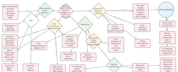
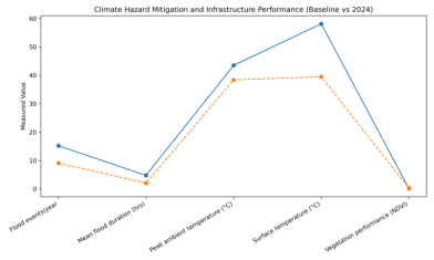
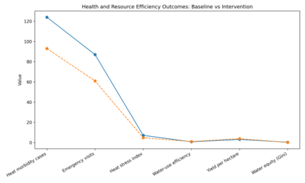
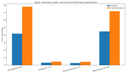
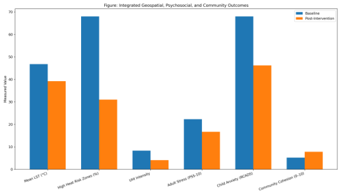
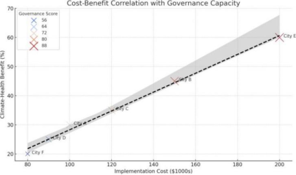
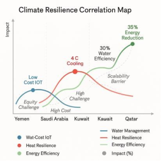
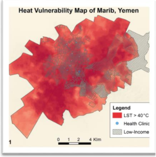
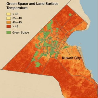
_simulation_of_Al-Rawdah_Park,_Marib,_Yemen._The_post-intervention_results_show_a_32%_decrease_in_child_anxiety_(RCADS),_a_25%_d.png)