This study was carried out during 2019 in El Slam and El Dweim localities WhiteNile State (WNS), Sudan with aim to investigate the impact of climate change vulnerability on crop production, forestry and range land in WNS. Three methods for data collection were used (1) Vulnerability assessment by using the satellite images (2) Key informant interview (KII), and (3) Focus group Discussion (FGD). The results showed that the main field crops in the two localities are sorghum, sesame, mellit, groundnut and watermelon and vegetable crops. Crop production was highly affected by climatic and non-climatic factors which include; low and erratic rainfall, outbreak of pest and diseases (striga), lack of improve seeds, lack of proper storage capacity, flooding especially, mono-cropping which lead to soil deterioration and striga infestation, lack of financial support and poor extension services. The remote sensing data from 2000-2018, showed that the forest cover in El Salam locality was decreased from 365,726 ha in 2000 to 147,089 ha in 2018 about 250,282 ha of the forest land were converted to non-forest land including 41% to agricultural land and 26% to grazing land. In contrast in El Dweim locality the results showed slight improvement in forest cover. The range condition in the two localities was deteriorated compared with the past periods. In Elsalam locality the range land was estimated at 264,702 ha in 2000, by year 2018 almost 85% of these areas were converted to non-grassland as follows:(75%) to agriculture land and (10%) to urban areas. In El Dweim locality the decrease is about 52%. Generally, the deterioration of the range land can be attributed to many factors such as low and erratic rainfall, fodder shortage, poor distribution of water point, fire outbreak and speared of invader species. The study recommended many intervention to improve agriculture production such as the dissemination of improved seeds (drought resistant and early maturing); promotion of vegetable production to improve nutrition. For bothforest and rangeland condition which include; planting of 10% of the area of the agricultural land with forest trees; establishment of shelterbelts and promotion of social forestry; and enforcement of natural resourceslegislation, provision of improved stove and LPG, introduction of agroforestry systems, establishment of community forestry, provision of tree seedlings, rehabilitation ofdegraded range land, opening of fire lines and provide new water.
| Published in | Science Discovery Agriculture (Volume 1, Issue 1) |
| DOI | 10.11648/j.sda.20260101.11 |
| Page(s) | 1-17 |
| Creative Commons |
This is an Open Access article, distributed under the terms of the Creative Commons Attribution 4.0 International License (http://creativecommons.org/licenses/by/4.0/), which permits unrestricted use, distribution and reproduction in any medium or format, provided the original work is properly cited. |
| Copyright |
Copyright © The Author(s), 2026. Published by Science Publishing Group |
Climate Change, Sudan, Agriculture, Forestry, El DuwaymLocalities
Village | Locality | Admin. unit | Description | Administrative bodies |
|---|---|---|---|---|
Mejikha | Alsalam | El Rawat | Surrounded by agricultural area, the houses are made of mud and rarely breaks | 2 sheikhs, One vice, Popular committee |
Alrawat | Alsalam | El Rawat | Surrounded by more than 4000 feddan of arable soils. The houses are made of red breaks and mud | One sheikh, One vice, Popular committee |
Duraa Alwaheed | Alsalam | El Rawat | The buildings composed of mud and straw and the whole village is surrounded by the agricultural lands | One sheikh, One vice, Popular committee |
Alsuwalik | Alsalam | El Rawat | The houses are made of palm leaves, straw, wood and mud. they used to be nomads and they recently settled in 2009 | One sheikh, One vice, Popular committee |
Wad Alkut | Alsalam | El Rawat | The houses are built from mud and most of it with no fences. | One sheikh, One vice, Popular committee |
Elhelba | El Dweim | Shabasha | The houses are build form mud, red breaks and cement blocks and the land is sandy soil. | One sheikh, One vice, Popular committee |
Agaidat El Tair | El Dweim | Shabasha | The whole area is sand soil, the houses are huts build from mud, wood and straw with very few made from red breaks (Durdur) | One sheikh, One vice, Popular committee) |
Wad Gabur | El Dweim | Shabasha | Sandy soil with buildings made of mud and red breaks. | One sheikh, One vice, Popular committee |
SN | Path | Row | Bands | Date of acquisition |
|---|---|---|---|---|
2 | P177 | R050 | Band1 - band7 | 12/23/2018 |
3 | P177 | R051 | Band1 - band7 | 12/23/2018 |
4 | P177 | R052 | Band1 - band7 | 12/23/2018 |
5 | P178 | R050 | Band1 - band7 | 12/21/2018 |
6 | P178 | R051 | Band1 - band7 | 12/21/2018 |
7 | P178 | R052 | Band1 - band7 | 12/21/2018 |
8 | P178 | R053 | Band1 - band7 | 12/21/2018 |
9 | P179 | R050 | Band1 - band7 | 12/28/2018 |
10 | P179 | R051 | Band1 - band7 | 12/28/2018 |
11 | P180 | R051 | Band1 - band7 | 12/19/2018 |
Vulnerability Class | Drought Class | VHI Range (%) |
|---|---|---|
Very High Vulnerable | Extreme Drought | 0-20 |
High Vulnerable | Severe Drought | 21–40 |
Moderate Vulnerable | Moderate Drought | 41–60 |
Slight Vulnerable | Slight Drought | 61–80 |
Non-vulnerable | No Drought | 81–100 |
Land use classes | Area (Ha) | Area (%) |
|---|---|---|
Agriculture | 421,497.5 | 44.8% |
Bare Area | 27.0 | 0.001% |
Forest | 101,712.1 | 10.8% |
Grass | 332,472.4 | 35.3% |
Settlement | 1,629.4 | 0.2% |
Shrubs | 76,695.0 | 8.1% |
Water Bodies | 7,256.4 | 0.8% |
Total | 941,289.7 | |
Agriculture | 318,760.0 | 51.0% |
Bare Area | 868.7 | 0.1% |
Forest | 70,777.7 | 11.3% |
Grass | 72,462.8 | 11.6% |
Settlement | 6,760.2 | 1.1% |
Shrubs | 148,268.1 | 23.7% |
Water Bodies | 6,953.3 | 1.1% |
Total | 624,850.7 |
Drought Index | Area (ha) | Area (%) |
|---|---|---|
Moderate drought | 544.8 | 0% |
Slight drought | 486,885.3 | 52% |
Non vulnerable | 453,859.5 | 48% |
Total area | 941,289.7 | |
Moderate drought | 270,957.6 | 43% |
Slight drought | 280,746.8 | 45% |
Non vulnerable | 73,145.5 | 12% |
Total area | 624,849.9 |
Land use (Ha) | Rangeland | Agriculture | Water bodies | Urban | Forest | Land use 2000 |
|---|---|---|---|---|---|---|
Rangeland | 40,972.1 | 198,076.0 | 1,045.5 | 965.0 | 23,643.6 | 264,702.3 |
Agriculture | 4,682.6 | 292,248.6 | 2,171.4 | 321.6 | 7,921.5 | 307,345.6 |
Water bodies | 212.0 | 40.1 | 3,136.4 | - | - | 3,388.5 |
Urban | 46.1 | - | - | - | 80.4 | 126.5 |
Forest | 94,950.0 | 151,231.0 | 3,297.2 | 804.1 | 115,443.9 | 365,726.2 |
Land use 2018 | 140,862.8 | 641,595.7 | 9,650.5 | 2,090.8 | 147,089.4 |
Land use (Ha) | RangeLand | AgricUture | Urban | WaterBodies | Forest | Baresoil | Land use 2000 |
|---|---|---|---|---|---|---|---|
Rangeland | 254,874.3 | 252,141.8 | 3,363.1 | 718.2 | 27,832.8 | 578.0 | 539,508.2 |
Agriculture | 14,363.1 | 61,410.9 | 700.6 | 2,715.0 | - | - | 79,189.5 |
Urban | 105.1 | 840.8 | 963.4 | 105.1 | 17.5 | - | 2,031.8 |
Water bodies | 175.2 | 175.2 | 17.5 | 2,785.0 | - | - | 3,152.9 |
Forest | 315.3 | - | - | 87.6 | 560.5 | - | 963.4 |
Bare soil | - | - | - | - | - | - | - |
Land use 2018 | 269,832.9 | 314,568.6 | 5,044.6 | 6,410.8 | 28,410.8 | 578.0 |
Land use (Ha) | Rangeland | Agriculture | Water bodies | Urban | Forest | Land use 2000 |
|---|---|---|---|---|---|---|
Rangeland | 40,972.1 | 198,076.0 | 1,045.5 | 965.0 | 23,643.6 | 264,702.3 |
Agriculture | 4,682.6 | 292,248.6 | 2,171.4 | 321.6 | 7,921.5 | 307,345.6 |
Water bodies | 212.0 | 40.1 | 3,136.4 | - | - | 3,388.5 |
Urban | 46.1 | - | - | - | 80.4 | 126.5 |
Forest | 94,950.0 | 151,231.0 | 3,297.2 | 804.1 | 115,443.9 | 365,726.2 |
Land use 2018 | 140,862.8 | 641,595.7 | 9,650.5 | 2,090.8 | 147,089.4 |
Event | Years | Impact | Copping strategy |
|---|---|---|---|
Drought | 1953 1984 1985 1991 1992 | Decrease in crop production and productivity, deterioration in rangelands, deterioration in forest covers, disappearance of some rangelands plants, Migration of wild animals | Collection of wild fruit trees, displacement to big cities |
Flooding | 2005 2012 2014 2019 | Destruction of basic infrastructure, houses, hospitals, water sources, market place, damage to farm and rangelands, crop failure, outbreak of pest and diseases | No specific copping strategy were mentioned |
AI | Aridity Index |
FGD | Focus Group Discussion |
HNO | Humanitarian Needs Overview |
IDP | Internally Displaced People |
KII | Key Informants Interview |
LST | Land Surface Temperature |
LULC | Land Use And Land Cover |
MoA | Ministry of Agriculture |
MODIS | Moderate Resolution Imaging Spectroradiometer |
NDVI | Normalized Difference Vegetation Index |
WNS | White Nile State |
TCI | Temperature Condition Index |
VCI | Vegetation Condition Index |
VHI | Vegetation Health Index |
| [1] | Abdel Magid, T. D. 2001. Forest Biodiversity in Sudan with particular reference to NWFPs. Forest National Corporation, Khartoum, Sudan. |
| [2] | CBoS (Central Bank of the Sudan). 2016. The 56th Annual Report of the Central Bank of the Sudan. Khartoum: CBoS. |
| [3] | Christensen, J. H., K. Krishna Kumar, E. Aldrian, S.-I. An, I. F. A. Cavalcanti, M. de Castro, W. Dong, P. Goswami, A. Hall, J. K. Kanyanga, A. Kitoh, J. Kossin, N.-C. Lau, J. Renwick, D. B. Stephenson, S.-P. Xie and T. Zhou, 2013: Climate Phenomena and their Relevance for Future Regional Climate Change. In: Climate Change 2013: The Physical Sci?ence Basis. Contribution of Working Group I to the Fifth Assessment Report of the Intergovernmental Panel on Climate Change. |
| [4] | Elsiddig, E. A., Mohamed, A. G. and Abdel Magid, T. D., 2011. Forest Plantations/Woodlots in Sudan. Sudan Report, African Forest Forum. |
| [5] | FAO (Food and Agriculture Organization of the United Nations). 2012. The Land Cover Atlas of Sudan. Rome: FAO |
| [6] | Ghebrezgabher, M. G., et al. (2020). Assessment of NDVI variations in responses to climate change in the Horn of Africa. The Egyptian Journal of Remote Sensing and Space Sciences, 23(3), 333-343. |
| [7] | MHRDL (Ministry of Human Resources Development and Labor). 2013. Sudan Labor Force Survey 2011 (SLFS 2011). Khartoum: MHRDL. |
| [8] | NAPA, 2016. National Adaptation Plan. Republic of the Sudan, Ministry of Environment and Physical Development, Higher Council for Environment and Natural Resources, Khartoum. |
| [9] | NAPA. 2007. National Adaptation programme of Action. Republic of the Sudan, Ministry of Environment and Physical Development, Higher Council for Environment and Natural Resources, Khartoum. |
| [10] | Oriandi, VA., and Zakieldeen, S. A. 2006. Integrating adaptation to climate change in to development plans and policies in Sudan. Ecopolicy Series 17, African Centre for Technology Studies (ACTS), Nairobi. |
| [11] | Saada, N. Ahmed., and Murtada Abdelkarim. 2019. Enhancing theresilience of communities living in climate change vulnerable areas of Sudan using Ecosystem Based Approaches to Adaptation Sudan EbAProject, the baseline survey report. |
| [12] | Sayed, M. A., and B. Abdala. 2013. Sudan Environmental and Climate Change Assessment. ECCA No. 3226-SD Rome: International Fund for Agricultural Development (IFAD). |
| [13] | SFNC. 2002. Sudan’s First National communication. Higher Council for Environment and Natural Resources (HCENR), Khartoum. |
| [14] | Sultan, M., Issa, S., Dahy, B., Saleous, N., & Sami, M. (2024). Fifty years of land use and land cover mapping in the United Arab Emirates: A machine learning approach using Landsat satellite data. Frontiers in Earth Science, 12, 1510510. |
| [15] | UNEP 2007. Natural Disasters and Desertification: Chapter 3 Sudan Post-Conflict Environmental Assessment 2007. |
| [16] | UNFPA 2013. United Nations Population Fund data 2013. |
| [17] | USAID (United States Agency for International Development). 2016. Climate Change Risk in Sudan: Country Fact Sheet. Washington, DC: USAID. |
| [18] | Walker, B., Holling, C. S., Carpenter, S. R., & Kinzig, A. (2004). Resilience, adaptability and transformability in social-ecological systems. Ecology and Society, 9(2), 5. |
| [19] | World Bank’s Natural Hotspots Study 2013. Flooding recently in July-August 2013 affected 47,000 families, killing 56 people and 36,000 heads of cattle and damaging 8,400 ha of cultivated land. |
| [20] | Zakieldeen, SA. 2007. Vulnerability in Sudan. tiempo bulletin 62. Online bulletin at: |
APA Style
Fadul, K. E. M., Elamin, E. T. M., Taha, A., Abdelftah, A., Khatir, A. A., et al. (2026). Effect of Climate Change Vulnerability on Agriculture, Forestry and Rangel Land Condition in White Nile State, Sudan (A Case Study of El Slam and El Dweim Localities). Science Discovery Agriculture, 1(1), 1-17. https://doi.org/10.11648/j.sda.20260101.11
ACS Style
Fadul, K. E. M.; Elamin, E. T. M.; Taha, A.; Abdelftah, A.; Khatir, A. A., et al. Effect of Climate Change Vulnerability on Agriculture, Forestry and Rangel Land Condition in White Nile State, Sudan (A Case Study of El Slam and El Dweim Localities). Sci. Discov. Agric. 2026, 1(1), 1-17. doi: 10.11648/j.sda.20260101.11
AMA Style
Fadul KEM, Elamin ETM, Taha A, Abdelftah A, Khatir AA, et al. Effect of Climate Change Vulnerability on Agriculture, Forestry and Rangel Land Condition in White Nile State, Sudan (A Case Study of El Slam and El Dweim Localities). Sci Discov Agric. 2026;1(1):1-17. doi: 10.11648/j.sda.20260101.11
@article{10.11648/j.sda.20260101.11,
  author = {Kamal Eldin Mohammed Fadul and El Tighani Mirghani Elamin and Abdelmoneim Taha and Abdelazia Abdelftah and Abdelrahman Ahmed Khatir and Bushra Meheissi and Fadwa Hassan Ibrahim and Dirdiri Hassan Mahmoud and Sona Mohammed Fadul},
  title = {Effect of Climate Change Vulnerability on Agriculture, Forestry and Rangel Land Condition in White Nile State, Sudan (A Case Study of El Slam and El Dweim Localities)},
  journal = {Science Discovery Agriculture},
  volume = {1},
  number = {1},
  pages = {1-17},
  doi = {10.11648/j.sda.20260101.11},
  url = {https://doi.org/10.11648/j.sda.20260101.11},
  eprint = {https://article.sciencepublishinggroup.com/pdf/10.11648.j.sda.20260101.11},
  abstract = {This study was carried out during 2019 in El Slam and El Dweim localities WhiteNile State (WNS), Sudan with aim to investigate the impact of climate change vulnerability on crop production, forestry and range land in WNS. Three methods for data collection were used (1) Vulnerability assessment by using the satellite images (2) Key informant interview (KII), and (3) Focus group Discussion (FGD). The results showed that the main field crops in the two localities are sorghum, sesame, mellit, groundnut and watermelon and vegetable crops. Crop production was highly affected by climatic and non-climatic factors which include; low and erratic rainfall, outbreak of pest and diseases (striga), lack of improve seeds, lack of proper storage capacity, flooding especially, mono-cropping which lead to soil deterioration and striga infestation, lack of financial support and poor extension services. The remote sensing data from 2000-2018, showed that the forest cover in El Salam locality was decreased from 365,726 ha in 2000 to 147,089 ha in 2018 about 250,282 ha of the forest land were converted to non-forest land including 41% to agricultural land and 26% to grazing land. In contrast in El Dweim locality the results showed slight improvement in forest cover. The range condition in the two localities was deteriorated compared with the past periods. In Elsalam locality the range land was estimated at 264,702 ha in 2000, by year 2018 almost 85% of these areas were converted to non-grassland as follows:(75%) to agriculture land and (10%) to urban areas. In El Dweim locality the decrease is about 52%. Generally, the deterioration of the range land can be attributed to many factors such as low and erratic rainfall, fodder shortage, poor distribution of water point, fire outbreak and speared of invader species. The study recommended many intervention to improve agriculture production such as the dissemination of improved seeds (drought resistant and early maturing); promotion of vegetable production to improve nutrition. For bothforest and rangeland condition which include; planting of 10% of the area of the agricultural land with forest trees; establishment of shelterbelts and promotion of social forestry; and enforcement of natural resourceslegislation, provision of improved stove and LPG, introduction of agroforestry systems, establishment of community forestry, provision of tree seedlings, rehabilitation ofdegraded range land, opening of fire lines and provide new water.},
 year = {2026}
}
TY  - JOUR
T1  - Effect of Climate Change Vulnerability on Agriculture, Forestry and Rangel Land Condition in White Nile State, Sudan (A Case Study of El Slam and El Dweim Localities)
AU  - Kamal Eldin Mohammed Fadul
AU  - El Tighani Mirghani Elamin
AU  - Abdelmoneim Taha
AU  - Abdelazia Abdelftah
AU  - Abdelrahman Ahmed Khatir
AU  - Bushra Meheissi
AU  - Fadwa Hassan Ibrahim
AU  - Dirdiri Hassan Mahmoud
AU  - Sona Mohammed Fadul
Y1  - 2026/02/14
PY  - 2026
N1  - https://doi.org/10.11648/j.sda.20260101.11
DO  - 10.11648/j.sda.20260101.11
T2  - Science Discovery Agriculture
JF  - Science Discovery Agriculture
JO  - Science Discovery Agriculture
SP  - 1
EP  - 17
PB  - Science Publishing Group
UR  - https://doi.org/10.11648/j.sda.20260101.11
AB  - This study was carried out during 2019 in El Slam and El Dweim localities WhiteNile State (WNS), Sudan with aim to investigate the impact of climate change vulnerability on crop production, forestry and range land in WNS. Three methods for data collection were used (1) Vulnerability assessment by using the satellite images (2) Key informant interview (KII), and (3) Focus group Discussion (FGD). The results showed that the main field crops in the two localities are sorghum, sesame, mellit, groundnut and watermelon and vegetable crops. Crop production was highly affected by climatic and non-climatic factors which include; low and erratic rainfall, outbreak of pest and diseases (striga), lack of improve seeds, lack of proper storage capacity, flooding especially, mono-cropping which lead to soil deterioration and striga infestation, lack of financial support and poor extension services. The remote sensing data from 2000-2018, showed that the forest cover in El Salam locality was decreased from 365,726 ha in 2000 to 147,089 ha in 2018 about 250,282 ha of the forest land were converted to non-forest land including 41% to agricultural land and 26% to grazing land. In contrast in El Dweim locality the results showed slight improvement in forest cover. The range condition in the two localities was deteriorated compared with the past periods. In Elsalam locality the range land was estimated at 264,702 ha in 2000, by year 2018 almost 85% of these areas were converted to non-grassland as follows:(75%) to agriculture land and (10%) to urban areas. In El Dweim locality the decrease is about 52%. Generally, the deterioration of the range land can be attributed to many factors such as low and erratic rainfall, fodder shortage, poor distribution of water point, fire outbreak and speared of invader species. The study recommended many intervention to improve agriculture production such as the dissemination of improved seeds (drought resistant and early maturing); promotion of vegetable production to improve nutrition. For bothforest and rangeland condition which include; planting of 10% of the area of the agricultural land with forest trees; establishment of shelterbelts and promotion of social forestry; and enforcement of natural resourceslegislation, provision of improved stove and LPG, introduction of agroforestry systems, establishment of community forestry, provision of tree seedlings, rehabilitation ofdegraded range land, opening of fire lines and provide new water.
VL  - 1
IS  - 1
ER  -
Department of Forest Silviculture, University of Khartoum, Khartoum, Sudan
Agricultural Economics & Policy Research Centre, Agricultural Research Corporations (ARC), Khartoum, Sudan
Agricultural Economics & Policy Research Centre, Agricultural Research Corporations (ARC), Khartoum, Sudan
Range and Forage Research Programme, Agricultural Research Corporation (ARC), El-Obeid, Sudan
Agricultural Economics & Policy Research Centre, Agricultural Research Corporations (ARC), Khartoum, Sudan
Department of Forest Protections and Conservation, University of Khartoum, Khartoum, Sudan
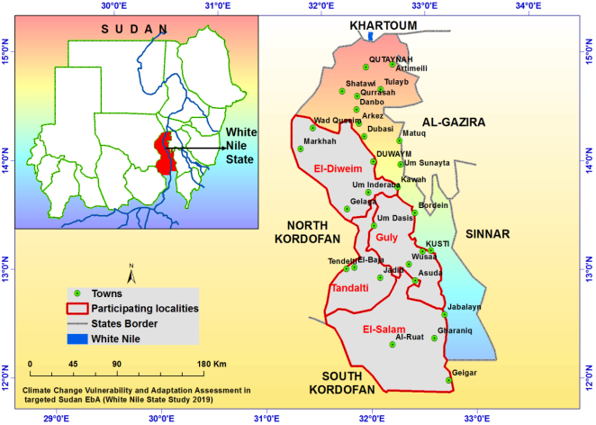
Figure 1. Targeted Localities.
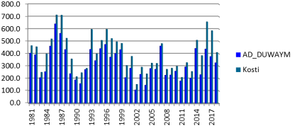
Figure 2. Average Rainfall in Kosti and Ad Dweim Localities from 1981-2018 Source (SMA).
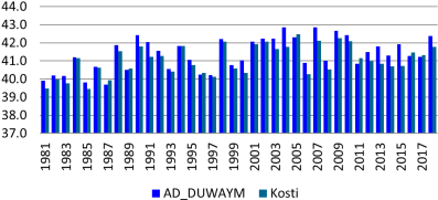
Figure 3. Average Maximum Temperature in Kosti and Al Dweim Localities from 1981-2018.
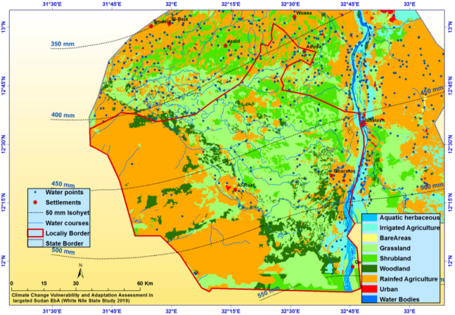
Figure 4. Land Use/Cover (LULC) at Al Salam locality.
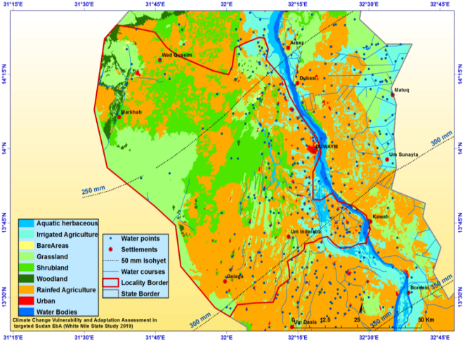
Figure 5. Land Use Land Cover (LULC) at El-DuwaymLocality.
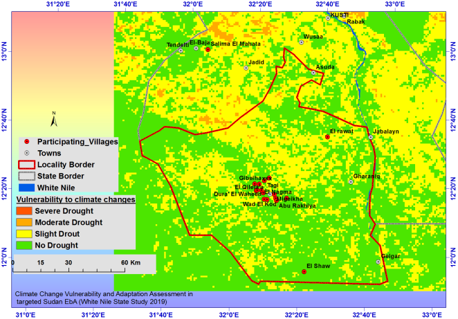
Figure 6. Climate Change Vulnerability at Al Salam Locality.
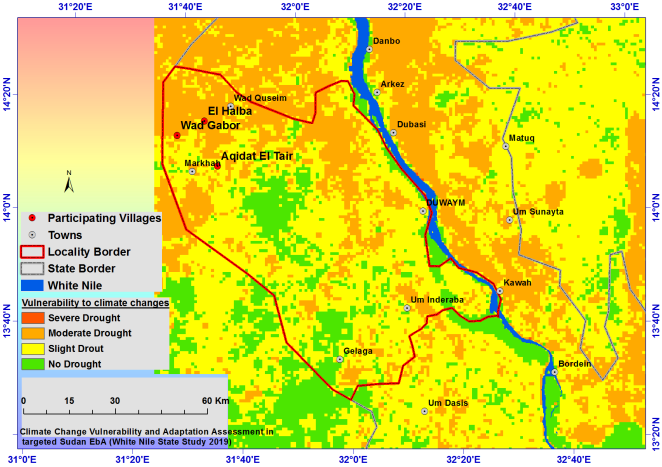
Figure 7. Climate Change Vulnerability at El-Dweim Locality.
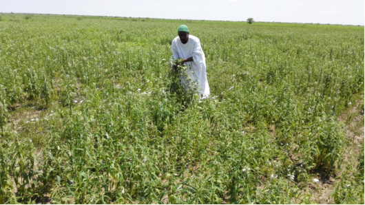
Figure 8. Sesame Demonstration farm in Al Salam Locality.
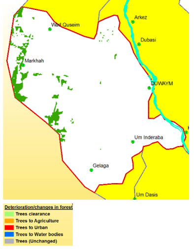
Figure 9. Identification of Changes/Deterioration in Forest Covers Between 2000 and 2018 2017.
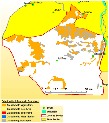
Figure 10. Changes in Range Land Between 2000 and 2018 in Al Salam Locality.
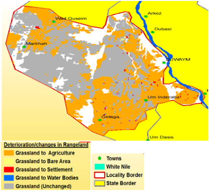
Figure 11. Changes in Range Land Between 2000 and 2018 in El Dweim Locality.
Information

