The complex fault block oilfield in Weixinan Sag is gradually entering the middle and late development stage and the middle and high water cut stage. The complex contradictions among layers, within layers and in the plane result in low efficiency of injection water waves, complex distribution of oil and water, and difficult to accurately predict the distribution of remaining oil. The fine characterization of the internal configuration of the reservoir was carried out to characterize the strong heterogeneity of the continental sedimentary complex fault block reservoir, and the flow unit was subdivided to qualitatively characterize the differences in the reservoir quality of sand bodies at different stages in the vertical direction of the reservoir, which brought new challenges to the fine geological modeling of the reservoir. In view of the lack of well data in offshore oil fields, sedimentary laws and geological knowledge base summarized in previous studies are used to constrain the modeling of braided river delta reservoir configuration. Taking Weizhou C Oilfield as an example, sequential indication, object, truncated Gauss Multipoint geostatistics isophase modeling method is preferred to establish underwater distributary channel model based on target method. The truncated Gaussian simulation method can effectively characterize the characteristics of the transition zone, establish the flow unit model, use the flow unit constraint attribute model to establish, further calculate the reservoir heterogeneity coefficient, accurately characterize the reservoir heterogeneity, and lay a good foundation for the next step of reservoir numerical simulation and tapping the potential of remaining oil.
| Published in | Earth Sciences (Volume 14, Issue 2) |
| DOI | 10.11648/j.earth.20251402.11 |
| Page(s) | 49-56 |
| Creative Commons |
This is an Open Access article, distributed under the terms of the Creative Commons Attribution 4.0 International License (http://creativecommons.org/licenses/by/4.0/), which permits unrestricted use, distribution and reproduction in any medium or format, provided the original work is properly cited. |
| Copyright |
Copyright © The Author(s), 2025. Published by Science Publishing Group |
Complex Fault, Truncate, Flow Unit, Configuration, Modeling
 ) to describe the heterogeneity characteristics of the reservoir. The coefficient of variation characterizes the degree of dispersion of permeability within a sand layer, which is represented by the ratio of the standard deviation of permeability of each individual sand layer in a certain well section to its average value. In the model, the ratio of the standard deviation of permeability between a single grid and its six adjacent grids to its mean value.
  ) of a single grcid connected to its surrounding six grids to its average value (
  ). Namely:
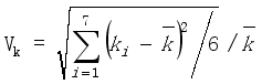
| [1] | MOU Zhonghai, LIU Xue, CHANG Lin, etc. Modeling of the Reservoir Architecture of Thin Interbedded Deposits [J]. Journal of Southwest Petroleum University (Science & Technology Edition), 2020, 42(3): 1-12. |
| [2] | WU Degang, etc. An intelligent 3D reservoir modeling method with constraint from planar distribution of sedimentary faciess [J]. Journal of China University of Petroleum (Edition of Natural Science), 2024, |
| [3] | XU ZhongBo, SHEN ChunSheng, CHEN YuKun, etc. Architecture Characterization For Sandy Braided River Reservoir and Controlling Factors of Remaining Oil Distribution [J]. ACTA SEDIMENTOLOGICA SINICA, 2016, 34(2): 375-385. |
| [4] | ZHANG Jianxing, LIN Chengyan, ZHANG Xianguo, etc. Remaining oil distribution of point bar Reservoir based on Reservoir Architecture and Reservoir numerical simulation [J]. Lithologic Reservoir, 2017, 29(4): 146-153. |
| [5] | LI Junfei, HUO ChunLiang, YE Xiaoming, etc. Internal architecture characteristics of sandy braided-river reservoirs in L Oilfield, Bohai Bay Basin [J]. Petroleum Geology and Recovery Efficiency, 2017, 24(6): 48-53. |
| [6] | HU Guangyi, XIAO Dakun, FAN Ting’en, etc. New theory and method of fluvial reservoir architecture study: Concepts, contents and characterization of offshore oilfieldfluvial compound sand-body architecture [J]. JOURNAL OF PALAEOGEOGRAPHY (Chinese Edition), 2019, 21(1): 143-159. |
| [7] | HU Guangyi, FAN Tingen, LIANG Xu, etc. Concept system and characterization method of compound sandbody architeccture in fluvial reservoir and its application exploration in development of Bohai oilfield [J]. CHINA OFFSHORE OIL AND GAS, 2018, 30(1): 89-98. |
| [8] | WANG Haifeng, HU Guangyi, FAN Ting’en, etc. Reservoir modeling of offshore composite sand architecture interface based on seismic attributes [J]. GEOPHYSICAL PROSPECTING FOR PETROLEUM, 2021, 60(6): 1016-1025. |
| [9] | MA Zhixin, WU Zheng, ZHANG Ji, etc. Static and dynamic information fusion based reservoir architecture characterization and 3D geological modeling technology for braided river reservoirs [J]. Natural Gas Industry, 2022, 42(1): 146-158. |
| [10] | YUAN Binglong, ZHANG Hui, YE Qing, etc. Flow-unit Classification Based on Compound Sand-Body Architecture of Delta and Distribution Pattern of Remaining Oil [J]. ACTA SEDIMENTOLOGICA SINICA, 2021, 39(5): 1253-1263. |
| [11] | YE Xiaoming, LIU Xiaohong, WANG Pengfei, etc. Meshless modeling method for reservoir configuration units [J]. CHINA OFFSHORE OIL AND GAS, 2021, 33(1): 113-118. |
| [12] | YE Xiaoming, LIU Xiaohong, ZHANG Lan, etc. Research progress on the architecture modeling methods [J]. CHINA OFFSHORE OIL AND GAS, 2022, 34(1): 84-93. |
| [13] | ZHANG Yi, SUN Dongsheng, XUE Dan. 3D architecture modeling of meandering river sand body [J]. Fault-Block Oil & Gas Field, 2019, 26(4): 470-474. |
| [14] | JIA Chen, XIAO Mei, LI Min, etc. Application of modeling method of meandering river point bar architecture in Gangdong Oilfield [J]. Complex Hydrocarbon Reservoirs, 2023, 16(3): 301-307. |
| [15] | NIU Bo, ZHAO Jiahong, FU Ping, etc. Trend judgment of abandoned channels and fine architecture characterization in meandering river reservoirs: A case study of Neogene Minhuazhen Formation NmⅢ2 layer in Shijiutuo bulge, Chengning uplift, Bohai Bay Basin, East China [J]. Petroleum Exploration and Development, 2019, 46(5): 891-901. |
| [16] | ZUO Yi, ZHAO Lala, SHI Zhuoli, etc. A modeling method for meandering-river point bar and its internal configuration [J]. NATURAL GAS EXPLORATION AND DEVELOPMENT, 2023, 46(1): 50-56. |
| [17] | CHEN Shizhen, LIN Chengyan, REN Lihua. Multi-scale geological modeling of meandering river under the control of architectural pattern: Taking Shinan block of Shengli Oilfield as an example [J]. Journal of China University of Mining & Technology, 2020, 49(3): 552-556. |
| [18] | WU Shenghe, YUE Dali, LIU Jianmin, etc. Hierarchy modeling of subsurface palaeochannel reservoir architecture [J]. Science in China Series D: Earth Sciences, 2008, 51(S2): 111-121. |
| [19] | YIN Yanshu, ZHANG Changmin, LI Shaohua, etc. A Pattern-based Multiple Point Geostatistics Method [J]. GEOLOGICAL REVIEW, 2014, 60(1): 216-221. |
| [20] | YU Siyu, LI Shaohua, HE Youbin, etc. Multiple-Point geostatistics algorithm based on pattern scale-down cluster [J]. ACTA PETROLEI SINICA, 2016, 37(11): 1403-1409. |
| [21] | LI Jun, LI Shaohua, CHANG Lunjie, etc. An improved Fluvsim algorithm about fluvial reservoir modeling [J]. Journal of Northwest University (Natural Science Edition), 2018, 48(5): 729-723. |
| [22] | GAO Boyu, SUN Lichun, HU Guangyi, etc. A discussion on a fluvial reservoir modeling method based on a single sandbody [J]. CHINA OFFSHORE OIL AND GAS, 2008, 20(1): 34-37. |
| [23] | WEI Feng, LI Yuelin, MA Guangchun. Configuration modeling of fan delta reservoir in First Member of Liushagang Formation of WZ11-1N oilfield in western South China Sea [J]. CHINA OFFSHORE OIL AND GAS, 2019, 31(2): 93-102. |
| [24] | YIN Shuzuo, YU Siyu, LI Shaohu, etc. Parameter optimization method of multi-point geostatistical modeling based on average entropy [J]. Science Technology and Engineering, 2021, 21(29): 12447-12453. |
| [25] | LI Shaohua, SHI Jinghua, YU Jinbiao, etc. Application of SinGAN method in sedimentary facies modeling [J]. Petroleum Geology and Recovery Efficiency, 2022, 29(1): 37-45. |
| [26] | YIN Yanshu, WANG Jin, WEN Zhigang, etc. Comparision of the Reservoir Stochastic Modeling for the Underwater Distributary Channels in Shallow Water Delta [J]. Journal of Southwest Petroleum University (Science & Technology Edition), 2013, 35(3): 47-51. |
| [27] | YE Xiaoming, WANG Pengfei, HUO Chunliang, etc. Key techniques for geological modeling of offshore complex clastic rock reservoir [J]. CHINA OFFSHORE OIL AND GAS, 2018, 30(3): 110-115. |
| [28] | CHEN Jianbo, SHU Xiao, WANG Yue, etc. Modeling method and equivalent permeability calculation of fluvial reservoir formation configuration [J]. Complex Hydrocarbon Reservoirs, 2023, 16(4): 420-426. |
APA Style
Baixiang, D., Zhaoqiang, Y., Kui, C., Jinlai, H., Qingshuai, W. (2025). Modeling Method of Braided River Delta Reservoir Configuration Based on Flow Unit. Earth Sciences, 14(2), 49-56. https://doi.org/10.11648/j.earth.20251402.11
ACS Style
Baixiang, D.; Zhaoqiang, Y.; Kui, C.; Jinlai, H.; Qingshuai, W. Modeling Method of Braided River Delta Reservoir Configuration Based on Flow Unit. Earth Sci. 2025, 14(2), 49-56. doi: 10.11648/j.earth.20251402.11
@article{10.11648/j.earth.20251402.11,
  author = {Dai Baixiang and Yang Zhaoqiang and Chen Kui and Huan Jinlai and Wang Qingshuai},
  title = {Modeling Method of Braided River Delta Reservoir Configuration Based on Flow Unit
},
  journal = {Earth Sciences},
  volume = {14},
  number = {2},
  pages = {49-56},
  doi = {10.11648/j.earth.20251402.11},
  url = {https://doi.org/10.11648/j.earth.20251402.11},
  eprint = {https://article.sciencepublishinggroup.com/pdf/10.11648.j.earth.20251402.11},
  abstract = {The complex fault block oilfield in Weixinan Sag is gradually entering the middle and late development stage and the middle and high water cut stage. The complex contradictions among layers, within layers and in the plane result in low efficiency of injection water waves, complex distribution of oil and water, and difficult to accurately predict the distribution of remaining oil. The fine characterization of the internal configuration of the reservoir was carried out to characterize the strong heterogeneity of the continental sedimentary complex fault block reservoir, and the flow unit was subdivided to qualitatively characterize the differences in the reservoir quality of sand bodies at different stages in the vertical direction of the reservoir, which brought new challenges to the fine geological modeling of the reservoir. In view of the lack of well data in offshore oil fields, sedimentary laws and geological knowledge base summarized in previous studies are used to constrain the modeling of braided river delta reservoir configuration. Taking Weizhou C Oilfield as an example, sequential indication, object, truncated Gauss Multipoint geostatistics isophase modeling method is preferred to establish underwater distributary channel model based on target method. The truncated Gaussian simulation method can effectively characterize the characteristics of the transition zone, establish the flow unit model, use the flow unit constraint attribute model to establish, further calculate the reservoir heterogeneity coefficient, accurately characterize the reservoir heterogeneity, and lay a good foundation for the next step of reservoir numerical simulation and tapping the potential of remaining oil.
},
 year = {2025}
}
TY  - JOUR
T1  - Modeling Method of Braided River Delta Reservoir Configuration Based on Flow Unit

AU  - Dai Baixiang
AU  - Yang Zhaoqiang
AU  - Chen Kui
AU  - Huan Jinlai
AU  - Wang Qingshuai
Y1  - 2025/03/06
PY  - 2025
N1  - https://doi.org/10.11648/j.earth.20251402.11
DO  - 10.11648/j.earth.20251402.11
T2  - Earth Sciences
JF  - Earth Sciences
JO  - Earth Sciences
SP  - 49
EP  - 56
PB  - Science Publishing Group
SN  - 2328-5982
UR  - https://doi.org/10.11648/j.earth.20251402.11
AB  - The complex fault block oilfield in Weixinan Sag is gradually entering the middle and late development stage and the middle and high water cut stage. The complex contradictions among layers, within layers and in the plane result in low efficiency of injection water waves, complex distribution of oil and water, and difficult to accurately predict the distribution of remaining oil. The fine characterization of the internal configuration of the reservoir was carried out to characterize the strong heterogeneity of the continental sedimentary complex fault block reservoir, and the flow unit was subdivided to qualitatively characterize the differences in the reservoir quality of sand bodies at different stages in the vertical direction of the reservoir, which brought new challenges to the fine geological modeling of the reservoir. In view of the lack of well data in offshore oil fields, sedimentary laws and geological knowledge base summarized in previous studies are used to constrain the modeling of braided river delta reservoir configuration. Taking Weizhou C Oilfield as an example, sequential indication, object, truncated Gauss Multipoint geostatistics isophase modeling method is preferred to establish underwater distributary channel model based on target method. The truncated Gaussian simulation method can effectively characterize the characteristics of the transition zone, establish the flow unit model, use the flow unit constraint attribute model to establish, further calculate the reservoir heterogeneity coefficient, accurately characterize the reservoir heterogeneity, and lay a good foundation for the next step of reservoir numerical simulation and tapping the potential of remaining oil.

VL  - 14
IS  - 2
ER  -
CNOOC China Ltd. Zhanjiang, Zhanjiang, China
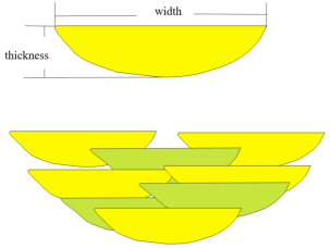
Figure 1. Channel profile and sand overlay mode.

Figure 2. Three modeling methods effect comparison.
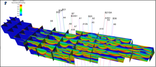
Figure 3. Profile of river channel configuration model framework of W3 Ⅳ oil formation.
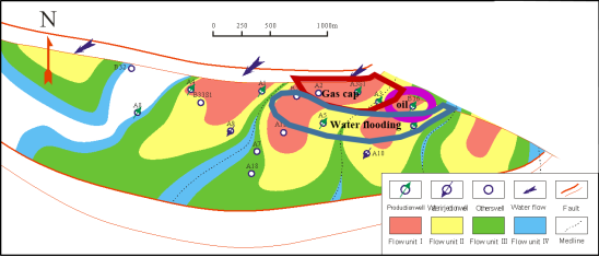
Figure 4. Plan Distribution of Flow Units in W3 Ⅳ Oil Formation.
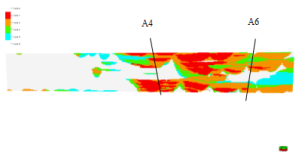
Figure 5. Intersection of flow unit model of W3 Ⅳ oil formation passing well A4-A6.
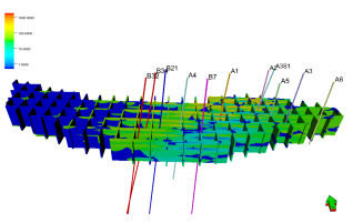
Figure 6. Profile of permeability model framework of W3 Ⅳ oil formation.
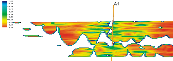
Figure 7. Profile of W3 Ⅳ Oil Formation Variation Coefficient Crosscutting Material Source Direction.
Information

