Abstract
Climate and land use changes have exacerbated the frequency and intensity of floods in West Africa. In Togo, the communities of the Zio river sub-basin are regularly affected by flood hazard with severe socio-economic consequences. The main objective of this article is to contribute to the improvement of the resilience of these populations through a better understanding of their perceptions and coping strategies to flood hazards. To achieve this goal, a mixed method consisting of household surveys, focus groups and direct observation is used. In addition, the data collected at the household level focused on the perceptions of the flood (origin and cause), the socio-economic impacts as well as the coping strategies. The results indicate that more than 80% of the households are affected by floods and the main negative consequences are the destruction of houses (40.8%), and interruption of socio-economic activities (58.4%). In addition, the efforts to cope with the severe impacts of floods include embankment (71.6%), storage on occasional shelves (52.3%), digging ditches (26.6% and the construction of cement houses with fairly raised foundations (13.1%). This study shows that is important to integrate indigenous knowledge and local population’s opinions in the flood risk management plans in order to increase their resilience.
Keywords
Floods, Perceptions, Coping Strategies, Resilience, Peri-Urban, Zio River Basin
1. Introduction
Climate change is increasing the frequency, intensity, location and impacts of natural hazards in many regions across the globe
. Climatic hazards reflect a threat whose negative effects are already being felt by people around the world. Indeed, these hazards have caused significant social, economic and environmental damages worldwide. Among the climatic hazards, floods are the most disastrous with a proportion that is growing steadily
| [2] | Haque, C. E.; Zaman, J. R.; Walker, D. 2023. Risk-Reduction, Coping, and Adaptation to Flood Hazards in Manitoba, Canada: Evidence from Communities in the Red River Valley. Geosciences 2023, 13, 88. https://doi.org/10.3390/geosciences13030088 |
[2]
. According to the 2020 World Disasters Report, floods are responsible for 40.3% of new displacements caused by climate and weather events
| [3] | IFRC. 2020. Rapport sur les catastrophes dans le monde en 2020. Contre marées et chaleurs. IFRC. Internal Displacement Monitoring Centre. Global Report on Internal Displacement (p. 159). |
[3]
. In this wake, the Observatory of Internal Displacement Situations reveals that more than 17 million people are each year exposed to the risk of displacement due to floods and more than 80% of them live in urban areas
. Thus, urban areas are considered as the most vulnerable to potential disasters since more than half of the world's population resides in areas facing accelerated urbanization and increased hazards
.
At a continental scale, Africa is also facing flood hazards in this context of global change. They account for more than 64% of disasters in this region
| [3] | IFRC. 2020. Rapport sur les catastrophes dans le monde en 2020. Contre marées et chaleurs. IFRC. Internal Displacement Monitoring Centre. Global Report on Internal Displacement (p. 159). |
[3]
. For instance, from June to September 2009, floods affected 600, 000 people and caused the death of 193 persons in twelve (12) West African countries
| [5] | Tazen, F., Diarra, A., Kabore, R. F. W., Ibrahim, B., Bologo/Traoré, M., Traoré, K., & Karambiri, H. 2019. Trends in flood events and their relationship to extreme rainfall in an urban area of Sahelian West Africa: The case study of Ouagadougou, Burkina Faso. Journal of Flood Risk Management, 12(S1), e12507. https://doi.org/10.1111/jfr3.12507 |
[5]
. In Ethiopia (East Africa), severe floods in 2003, 2005 and 2006 killed 119, 211 and 951 persons respectively
| [6] | Weldegebriel, Z. B., & Amphune, B. E. 2017. Livelihood resilience in the face of recurring floods: An empirical evidence from Northwest Ethiopia. Geoenvironmental Disasters, 4(1), 10. https://doi.org/10.1186/s40677-017-0074-0 |
[6]
. Furthermore, some projections indicate a likely increase in flood risks on the continent especially in tropical regions
| [7] | GIEC 2014. Changements climatiques 2014: Rapport de synthèse. Contribution des Groupes de travail I, II et III au cinquième Rapport d’évaluation du Groupe d’experts intergouvernemental sur l’évolution du climat. Genève, Suisse, 2014, 161 p. |
[7]
. This situation will lead to increased exposure of vulnerable communities.
In Togo, between 2007 and 2011, floods were marked by loss of human lives and other social and economic damages. For example, floods in September 2007 killed about 23 persons
| [8] | Tschakert, P., Sagoe, R., Ofori-Darko, G., & Codjoe, S. N. 2010. Floods in the Sahel: An analysis of anomalies, memory, and anticipatory learning. Climatic Change, 103(3), 471-502. https://doi.org/10.1007/s10584-009-9776-y |
[8]
. In 2008, the Togolese Red Cross estimated six deaths, 80 injuries, and thousands left homeless throughout the country during floods caused by heavy rainfalls from 15 to 17 July. According the government officials, these storms crushed nine bridges and cut off access to northern flood victims. Again, in 2010, 21 persons lost their lives and 85 were injured during severe floods in Togo
| [9] | ANGE 2020. Premier rapport sur l’état de l’environnement du Togo (REET). MEDDPN, Lomé, République togolaise |
[9]
. The Greater Lomé and its outlying areas which drain the Zio River are among the most affected zones. For people living in the peripheral sectors of Greater Lomé at the Zio valley, each rainy season is feared as it is a period during which floods occur with severe damages.
In the aftermath of these disastrous floods, some strategies and policies were put in place by the Togolese government in order to reduce flood risk in the Country. First, the Government established in 2007, the national natural disaster risk reduction coordination platform with a technical secretariat designed to serve as a standing national managerial board. In addition, the country initiated in 2009, a national capacity-building process through the national platform and the formulation of a national disaster risk reduction strategy
. Secondly, an integrated disaster and land management project was implemented from November 2014 to June 2017 in order to improve flood risk management in Togo. This project enables the operationalization of a flood early warning system in the Mono River Basin and an institutional strengthening for flood risk management in the country. In 2017, a national agency for civil protection was created in order to ensure an efficient management of disaster risk in Togo. According to a report published by the United Nations Economic Commission for Africa (ECA), the main weaknesses in flood management policies are the weakness of the information system such as vulnerability analysis, risk map; the little involvement of communities and civil society in disaster risk reduction as well as difficulties to implement the national and regional plans for land management
.
Many studies have explored flood risk situation in Togo. For instance, ref.
| [11] | Kouamé, P. K.; Fokou, G.; Koffi, A. J. d.; Sani, A.; Bonfoh, B.; Dongo, K. 2022. Assessing Institutional Stakeholders’ Perception and Limitations on Coping Strategies in Flooding Risk Management in West Africa. Int. J. Environ. Res. Public Health, 19, 6933. https:// doi.org/10.3390/ijerph19116933 |
[11]
assessed the perception of institutional stakeholders and limitations on coping strategies in flooding risk management in Abidjan (Côte d’Ivoire) and Lomé (Togo) whereas ref.
| [12] | Sokemawu, K. 2017. Les inondations et leurs répercussions socio-économiques et sanitaires dans la basse vallée du Zio au sud du Togo. Revue Ivoirienne de Géographie des Savanes, 2, 6-18. |
[12]
has analyzed the socio-economic impacts of floods in the lower valley of Zio river and found that the recurrent floods in this area have seriously affected the living conditions and health of the population, whereas ref.
| [13] | Klassou, K. S. 2014. L’influence humaine dans l’origine et la gravité des inondations au Togo: Cas de l’aménagement de l’espace dans la grande banlieue nord de Lomé (Togble-Adetikope). Revue de Géographie Tropicale et d’Environnement, 2, 41-53. |
[13]
has explored the role of urban expansion as well as climatic and geomorphological factors in generating floods in Lomé and revealed that with an urban growth rate of 6%, more people will be affected by flood in future if nothing is done. The same author has investigated the influences of human activities on the exacerbation of floods at Toble-Kope – a suburb located in the northern part of Greater Lome and showed that human activities have considerably changed the hydrological behavior of the Zio River leading to its overflowing almost each rainy season. Moreover, ref.
| [14] | Kissi, A. E., Abbey, G. A., Agboka, K., & Egbendewe, A. 2015. Quantitative Assessment of Vulnerability to Flood Hazards in Downstream Area of Mono Basin, South-Eastern Togo: Yoto District. Journal of Geographic Information System, 7(6), Article 6. https://doi.org/10.4236/jgis.2015.76049 |
[14]
have assessed flood vulnerability in Yoto district (lower Mono River Basin) and found that flood disaster is not only due to the high variability of the river discharges, but also to the interaction between humans and the environment. In the same area, ref.
| [15] | Parkoo, E. N., Thiam, S., Adjonou, K., Kokou, K., Verleysdonk, S., Adounkpe, J. G., & Villamor, G. B. 2022. Comparing Expert and Local Community Perspectives on Flood Management in the Lower Mono River Catchment, Togo and Benin. Water, 14(10), Article 10. https://doi.org/10.3390/w14101536 |
[15]
compared experts and local community perspectives on flood management and indicated that adapting risk communication and measures taken for flood management in accordance with the perceptions of affected communities could greatly increase the efficiency of the flood management strategies. In northern part of the country, ref.
| [16] | Komi, K., Amisigo, B. A., & Diekkrüger, B. 2016. Integrated Flood Risk Assessment of Rural Communities in the Oti River Basin, West Africa. Hydrology, 3(4), Article 4. https://doi.org/10.3390/hydrology3040042 |
[16]
assessed flood risk in the Oti River basin and showed a moderate level of flood risk despite a high level of hazard and vulnerability for all the investigated communities. However, little studies have been undertaken to analyse flood risk in the Zio river sub-basin. Thus, the main objective of this study is to analyse the perceptions of the communities in the Zio valley and their coping strategies to flood hazard. The study of these strategies is therefore necessary to identify the best practices which should be reinforced and promoted in order to reduce the vulnerability and improve the resilience of the population living in Zio river basin. Specifically, this involves analyzing the: (i) the socio-economic impacts of floods, (ii) causes of floods as perceived by the local population as well as (iii) coping strategies put in place by the communities to strengthen their resilience in the face of the recurrent flood hazard.
2. Materials and Methods
2.1. Conceptual and Analytical Frameworks
Some definitions have been proposed in different contexts for the concept of “vulnerability”. The first descriptions were made by Kates (1971) who defined vulnerability as “a decision model to decide how people understand hazards”. Few years later, many researchers have attempted to explain the word “vulnerability “in relation to environmental hazards (Wisner et al., 2015), in context of climate change (IPCC, 2020) and with regards to floods (Kumar & Bhattacharjya, 2020). In this study, a community is considered vulnerable when its characteristics and circumstances make it susceptible to the negative consequences of a risk (Kidokoro, 2008).
Two main methods are used to analyses vulnerability to natural and human-induced hazard namely the indicators-based approaches (Dottori et al., 2018) and participatory approach where communities at risk are involved in giving their own experience and perceptions (Cruz-Bello & Alfie-Cohen, 2022). In this study, participatory and mixed (qualitative and quantitative) method which enable a comprehensive assessment of vulnerable population were used. The combination of quantitative and qualitative approaches has the advantage of providing a holistic flood vulnerability analysis and takes into account the social aspects of the individuals.
2.2. Study Area
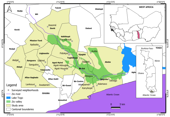
This study was conducted in 13 cantons in the Zio river sub-basin (
Figure 1). Some of these cantons were selected because of their localization in the lower the Zio valley while others are situated at the lowlands and are thus prone to floods. Within the cantons of the study area, 18 neighborhoods (
Figure 1) were selected based on tree criteria to carry out the investigations. These criteria are the area of residence, the demographic weight and the frequency of flooding in recent years.
Figure 1. Location of the study area.
The overall population of these 13 cantons is estimated in 2022 at 1,530,316 inhabitants (
Table 1) by applying to the data from the 4th General Population and Housing Census of 2010, the geometric formula of the growth rate opposite (Equation
1):
where Pn represents the population to be estimated; PO, the initial population; r the average annual growth rate of the maritime region (3.16%) and n the difference between the initial and final years (2022-2010 = 12).
Table 1. Selected cantons.
Cantons | Population in 2010 | Estimated population in 2022 | Selected localities |
Togble kope | 26830 | 38972 | Fidokpui |
Adetikopé | 20238 | 29397 | Tonoukouti |
Mission Tové | 9040 | 13131 | Apéssito |
Aképé | 6097 | 8856 | Aképé |
Legbassito | 29348 | 42630 | Dalimé |
Djagble | 16890 | 24534 | Djagblé |
Davie | 13388 | 19447 | Assomé |
Abobo | 15655 | 22740 | Avéta |
Sanguera | 38349 | 55704 | Sanguera |
Afla Sagbado | 93969 | 136496 | Awatame, Lankouvi |
Baguida | 117350 | 170459 | Devego, Adamavo |
Agoe -Nyive | 258389 | 375327 | Agoè Adjougba, Agoè Houmbi |
Bè Est | 407983 | 592622 | Attiegou, Adakpamé, Kanyikopé |
Total | 1053526 | 1530316 | - |
2.3. Data Collection
In this study, many methods were used to collect the required information namely: household surveys and focus group. The data collection took place from April 9 to 23, 2022. This period corresponds to the onset of the rainy season during which flood zones are most evident in the study area. The main difficulty encountered is the unwillingness of some the inhabitants to participate to the surveys.
In order to determine the sample size of the household surveys, the formula of
| [17] | Krejcie, R. V., & Morgan, D. W. 1970. Determining Sample Size for Research Activities. Educational and Psychological Measurement, 30, 607-610. |
[17]
was used:
Where s = represents the expected sample size; X = confidence level (1.96 at 95% confidence intervals); N = Population size of the study area; P = the estimated proportion of the population (0.5); d = the degree of precision expressed as a proportion (taken as 5%).
Based on this formula, a sample of 385 individuals is required. The sample was broken down into the cantons and then the neighborhoods in proportion to their demographic weight (
Table 2).
Table 2. Breakdown of the sample per canton.
Cantons | Population in 2022 | Percentage of the total population in 2022 | Estimated sample size |
Togble kope | 38972 | 2,5 | 10 |
Adetikopé | 29397 | 1,9 | 7 |
Mission Tové | 13131 | 0,9 | 4 |
Aképé | 8856 | 0,6 | 2 |
Legbassito | 42630 | 2,8 | 11 |
Djagble | 24534 | 1,6 | 6 |
Davie | 19447 | 1,3 | 5 |
Abobo | 22740 | 1,5 | 6 |
Sanguera | 55704 | 3,6 | 14 |
Aflao Sagbado | 136496 | 8,9 | 34 |
Baguida | 170459 | 11,1 | 43 |
Agoe Nyive | 375327 | 24,5 | 94 |
Bè Est | 592622 | 38,7 | 149 |
Total | 1530316 | 100 | 385 |
The data collected at the household level focused on the perceptions of the flood (origin and cause), the socio-economic impacts, the coping strategies and the types of assistance received during flood events. In addition, they were asked to assign scores of severity to the flood impacts and the effectiveness of coping strategies. In both cases, a scale from 0 to 3, recommended by ref.
| [18] | CARE International. Manuel d’analyse de la Vulnérabilité et de la capacité d’adaptation au Changement climatique. 2009, available at: http://www.careclimatechange.org |
[18]
was used: 0 = negligible impact / ineffective strategy, 1 = low impact / ineffective strategy, 2 = medium impact / effective strategy, 3 = significant impact / very effective strategy.
Moreover, the focus groups brought together people who had lived for at least 25 years in the study area. In total, 13 focus groups were conducted, one per canton. The focus groups involved 137 people, 42% of whom were women. Each discussion group brought together 8 to 12 people with whom exchanges were conducted to deepen the issues addressed during the household surveys, but also to explore the history of flood events and collect suggestions to cope with this natural disaster. In addition, the discussions focused on the history of the occurrence of floods in each environment, the damage caused and the preventive measures put in place.
2.4. Data Processing
The quantitative data from the household surveys were subjected to descriptive statistical analysis in SPSS 26 and Excel 2021 software and the frequencies and averages were calculated. The collected data during the focus groups were transcribed and compiled in order to constitute a corpus of data. This corpus was then subjected to content analysis
| [19] | Bardin, L. 2013 L’analyse de contenu (2e éd.). PUF. |
[19]
using Nvivo 12 software. This analysis followed three stages as described by
| [20] | Frederico, M., Arnaldo, C., Capurchande, R., Decat, P., & Michielsen, K. 2023. Adults’ Perceptions on Adolescent Attitudes towards Pregnancy and Abortion in Maputo and Quelimane Cities, Mozambique: An Exploratory Qualitative Study. SocialSciences, 12(1), Article 1. https://doi.org/10.3390/socsci12010029 |
[20]
: reading, encoding and analysis which enabled us to build up the thematization grid built around the following keywords: impacts on livelihoods, perceptions of the causes of flooding and coping strategies, corresponding to nodes in which all related text units have been grouped. This enable the identification of the various trends, the multiplicity of points of view and to retain relevant verbatims.
3. Results
3.1. Socio-Economic Impacts of Floods
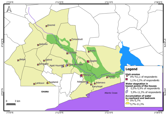
The peri-urban and urban parts of the Zio valley have always experienced flooding. But the intensities of the flood events have increased over the years and have caused significant material damages as well as loss of human lives. The analysis of flood history in the study area reveals that the years 1962, 2008 and 2019 are those which were characterized by the most catastrophic floods. In 1962 and 2008, the floods were mainly due to an overflow of Zio River which destroyed houses and crops (riverine floods), while in 2019, the floods were predominantly caused by heavy rainfall associated with excessive runoff because of the increased impermeability (pluvial flood). As shown in
Figure 2, they are manifested at the household level by stagnation of water in the low points of the house (73.4%), accumulation of water in the yard and in the rooms (69.8%) as well as strong erosion (7.2%). A participant to the focus group at Adakpamé expresses herself on the impacts she has already suffered in the following terms: “
In our houses, each season the water accumulates in the house and mixes with the sump. After a few days of rain, water even comes out of the ground inside the house” (focus group, 15.04.2022). The duration of floods varies from place to place. It varies from a week (33%) to 1 month (24.8%) and 3 months or more (23%).
Figure 2. Flood manifestations by respondent in Zio river.
Furthermore, 81.5% of the participants reported that their homes have been flooded, while the rest of the sample, who have not experienced this situation, still acknowledge the significance of its impact on their livelihoods. Indeed, floods have significant negative impacts on people's livelihoods which are identified at several levels. In terms of dwellings, it should first be noted that the houses occupied by the populations are mainly built in solid blocks of cements with a sheet metal or tile roof (91.9% o). The rest of the houses are built with blocks of muds covered by sheet metal roof (6.3%), straw roof (1.4%) and unsafe materials (0.5%). The results indicated that of all the households living in permanent houses with sheet metal/tile roofing, some are affected by the floods (58.6 %) while others are not affected (41.4%). As far as households living in mud houses with straw roofs and those living in precarious or salvage dwellings are concerned, they are all affected (100%). For households living in muddy houses with sheet metal roofs, only 28.6% are spared from flooding (
Table 3). We can deduce that people are impacted by floods regardless of the type of dwelling occupied.
Table 3. Breakdown of affected and unaffected respondents by type of dwelling.
Types of houses | % of unaffected households | % affected households | Total |
Cement house with metal or tile roofs | 41,4 | 58,6 | 100 |
Mud house with straw roof | 0 | 100 | 100 |
Mud house with metal roof | 28,6 | 71,4 | 100 |
Precarious house | 0 | 100 | 100 |
The impacts of floods on dwellings are mainly manifested by partial or total destruction of houses. It should be noted that the destruction of houses is also a consequence of erosion due to flooding.
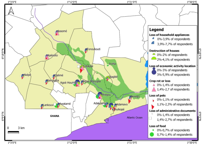
Economically, the damages are related to places of activity that are either inaccessible or unusable due to the presence of water. Indeed, during flood events, the households whose places of activity are affected find themselves without sources of incomes or with important reduction of earnings, thus contributing to increasing the household's vulnerability to floods. They are essentially merchants (36%) and craftsmen (28.8%). It should also be noted that the floods cause a slowdown in economic activities in the area, thus preventing 58.4% of respondents from doing their business. Two reasons are given to explain this situation. For 22.5% of respondents, it is the loss of their place of business (
Figure 3), and for 35.9%, the inaccessibility of these locations to customers is reported. More specifically, women are the most affected: the survey showed that 67. 3% of them (33.3% of the whole sample) stopped their activities during flood events against 49.5% (24.7% of the sample) for men.. In this regard, a respondent said during the focus groups at Attiegou: “
I sell food in a shed in the neighborhood. When it rains during consecutive days, all the place that i occupy is flooded and with a lot of mud everywhere when the water begins to infiltrate. Not only can customers not come and buy, but also I myself have to stop going to sell” (Focus group, 16.04.2022). To these impacts, one should add the loss of crops in the fields (12.2%) and domestic animals (11.3%). In addition to damage related to socio-economic activities, floods are source of destruction of various goods, namely household appliances (38.3%), losses of administrative documents (8.6%) as well as food (5%) (
Figure 3).
Figure 3. Types of flood damages in the study area according to respondents.
Furthermore, floods have negative repercussions on the health of the local population. Indeed, in some areas such as the coastal strip to the south-east of the valley, they cause pollution of water which is often used for cooking. Most often, wastewater and sludge from cesspools and septic tanks overflow and mix with flood water and thereby pollute the water resources. Thus, 48.2% of respondents do not have access to drinking water during floods. Under these conditions, we are witnessing a resurgence of various waterborne diseases. In addition, during flood events, it is difficult to travel. This situation impedes 50.7% of surveyed households to have access to health centers.
Education is not spared from the floods either. According to the people met during the focus groups, the floods also affect schools as well as schoolyards and classrooms end up in water. As a consequence, children have difficulty in accessing classrooms or are forced to stay at home until the end of the flooding.
Also, the household surveys provided an overview of the negative impacts of floods on people's lives. The self-assessment of flood damages by households enables the understanding of their degree of severity. The results of the study place this degree of severity at an average of 2.05 out of 3 and thereby demonstrate the urgency of finding sustainable solutions to reduce the vulnerability of the affected people. As far as women are concerned, there is a higher severity score compared to men. It is around 2.11 out of 3 while for men, the score is 1.9 on the same scale.
However, it is important to mention that floods are a source of abundance of fish products in the Zio River. Thus, periods of flooding represent a godsend for professional fishermen and young people converted to occasional fishermen to make additional incomes through the sale of fishes.
3.2. Perception of the Causes of Floods
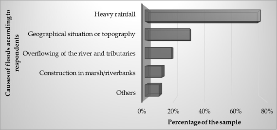
The study revealed that the recurrent floods in the Zio river basin have various causes
according to the perceptions of informers. The most common ones mentioned by the surveyed households are excessive rainfall (77.5% of the respondents) and the topography (30.2%). Indeed, the rainfall regime which has been characterized in recent years by intense and/or prolonged rains represents, according to the majority of the households, an important explanatory factor of floods. In addition, the most heavily impacted areas are found in the lowlands which receive rainwater from upper neighborhoods. These two causes are followed by the overflow of rivers (17.6%) and construction in marshy areas (11.3%) (
Figure 4).
In addition to those revealed by the household surveys, the group discussion helps in identifying additional causes such as urban growth, faulty and inefficient construction of public road, sanitation and agricultural development works as well as insufficient management of household waste. In other words, urban growth with the sprawl of urban space and anarchic settlements on floodplains block the natural path of runoff water. This results in the stagnation of rainwater in the streets with the risk of overflow in the surrounding homes. In addition, the faulty and inefficient construction of public road lead to flooding due to the flow of rainwater from the gutters to the lowlands. This is the case at Attiegou, Adjougba and the districts of the same sector where the floods have worsened with the construction of the great bypass. Some of the gutters of this great bypass have as outlets the low areas of lowlands which are nevertheless densely populated. The people met in Attiégou say: “Before the construction of the bypass, we had flood problems but not like that. The road diverts all the water from the heights above us and we find ourselves in the water every season” (Focus group, 16.04.2022). In other areas like Adakpamé and Kanyikopé, some gutters end in the middle of the street without any outlet. These gutters are therefore very quickly overflowed in the event of heavy rains and contribute to the aggravation of floods. Other gutters have a higher level than the streets they cross and are therefore unable to collect the runoff water. Elsewhere, agricultural infrastructures are built without taking into account the natural flow of rainwater. This is the case of the southern part of Djagblé with the Rural Development Project of the floodplain of Djagblé (PDRD) whose implementation has caused the obstruction of the rainwater pathways thereby causing flooding in the area. Concerning this sector of Djagblé, the participants in the focus group declared: “we don't even know which technicians are doing the work on the canal that feeds the rice field. They came to block the natural path of water with this work without finding a solution to convey the rainwater. Now the floods are so frequent that people are starting to abandon their homes” (Focus group, 17.04.2022).
Figure 4. Causes of flood by respondents.
Furthermore, the public management of household wastes is a factor not to be overlooked in floods. This management consists of several methods of waste disposal among which, the dumping of garbages, sludge and waste water in the gutters. This method of waste disposal leads to clogging of gutters and lead to floods. Beyond all these causes, it should also be noted that in some areas, the soil has reached a high level of saturation. Consequently, rainwater infiltrates with difficulty and very slowly. All the causes identified in this work contribute to an increased vulnerability of the populations to floods in the study area. Thus, coping strategies have been developed by the local population to increase their resilience to floods.
3.3. Coping Strategies Adopted and Perceptions of Their Effectiveness
The strategies put in place by the local population to deal with the floods are diverse. These are strategies applied with the aim of preventing flood-related disasters. As shown in
Figure 5, the most frequent strategies are- embankment (71.6% of the sample), storage on occasional shelves (52.3%) and digging of channels (26.6%). For flood victims, embankment consists of raising the ground level of the yard or the front of the house by pouring sand into it to prevent puddles. The storage on circumstantial shelves reflects efforts to place the goods on tables and stones so that they are not damaged by the floodwater when the room is inundated. As for the digging of channels, it consists of draining the water by widening its path using rudimentary materials such as hoes, pickaxes and shovels. It is an activity that is done both individually and collectively. These strategies are followed by temporary relocation (16.7%) and the construction of cement houses with fairly raised foundations (13.1%). The other strategies consist of consolidating mud constructions laying stones to be able to move through puddles, installing pipes to drain water or even making holes in the walls to drain water out of the houses. There is also the use of sandbags, to form sand dykes at the entrances of the houses. In extreme cases, canoes are used to move on the water.
Figure 5. Coping strategies adopted by respondents.
Figure 6. Effectiveness of flood coping strategies according to respondents.
Regarding the effectiveness of the coping strategies mentioned above, the results obtained from the self-assessment by households show that the most effective strategies are the construction of cement houses, storage on circumstantial shelves and the temporary move with respective averages of 2.2, 1.8 and 1.4 out of 3 (
Figure 6). The least effective strategies are embankment (1.1) and digging of channels (0.9).
The low effectiveness of these strategies is explained by the fact that the ground being waterlogged at the beginning, the backfilled parts are also quickly submerged in the event of heavy rains. The dug channels are quickly destroyed by erosion since they are made in the ground without the use of cement. In addition, the shallow depth of the channels means that they are also quickly submerged by water. In addition to the coping strategies, a very small proportion of those surveyed claim to receive assistance mainly from the government during floods. This assistance takes the form of donations of foods, soap and hygiene products and drugs. In addition, it should be noted that the communities receive early warnings especially during the rainy season. These warnings are transmitted to them through various channels such as radio (80%) and television (57.7%). We also note the use of other channels like the communication services of town halls.
4. Discussion
The results of this study provide information on the vulnerability and coping strategies in the Zio river basin. It highlights the impacts of floods on people's lives, their perceptions of the causes as well as the coping strategies put in place. The flood consequences revealed in this work are diverse. These include the loss of household goods, the destruction of houses, the loss of places of economic activities, the resurgence of waterborne diseases. These damages were also noted in the Zio valley by ref.
| [12] | Sokemawu, K. 2017. Les inondations et leurs répercussions socio-économiques et sanitaires dans la basse vallée du Zio au sud du Togo. Revue Ivoirienne de Géographie des Savanes, 2, 6-18. |
[12]
which classifies them in two main categories, namely the social effects linked to floods and the economic repercussions. These types of impacts are also revealed in the savannah region of Togo by ref.
| [21] | Badameli, A. P., & Kadouza, P. 2020. Vulnérabilités et stratégies des populations face aux inondations dans la région des Savanes au Nord-Togo. Canadian Journal of Tropical Geography, 7(2), 8. |
[21]
who pointed out that homes are one of the sectors most affected by floods. According to these authors, floods also favor the formation of puddles in which proliferate pathogens and vectors of waterborne diseases that threaten the health of populations. In Ghana, ref.
| [22] | Braimah, M. M., Abdul-Rahaman, I., Sekyere, D. O.-, Momori, P. H., Abdul-Mohammed, A., & Dordah, G. A. 2014. Study into the Causes of Floods and its Socio-economic Effects on the People of Sawaba in the Bolgatanga Municipality, Upper East, Ghana. International Journal of Pure & Applied Bioscience, 2(1), 189-195. |
[22]
notes that the floods affect the health of the populations through many injuries and deaths while ref.
| [23] | Dziwornu, E., & Kugbey, N. 2015. Mental Health Problems and Coping among Flood Victims in Ghana: A Comparative Study of Victims and Non-Victims. Current Research in Psychology, 2015, 6(1), 15-21. https://doi.org/10.3844/crpsp.2015.15.21 |
[23]
discovers mental problems in some flood victims in the Eastern Region.
Along the same lines as the results of the present study, ref.
| [24] | Tomety, Y. D. 2017. Exposition et vulnérabilité face aux risques d’inondation au Burkina Faso: Cas de la ville de Dori [Master de spécialisation en gestion des risques et des catastrophes]. Université de Liège., Belgique. |
[24]
as well as ref.
| [21] | Badameli, A. P., & Kadouza, P. 2020. Vulnérabilités et stratégies des populations face aux inondations dans la région des Savanes au Nord-Togo. Canadian Journal of Tropical Geography, 7(2), 8. |
[21]
consider, in the light of their studies that floods contribute to the slowing down of economic activities. This is explained by the fact that trade between localities is disrupted by travel difficulties and that access to the market becomes difficult during floods. These economic impacts strongly affect women, resulting in the loss of incomes from activities carried out at home. They are prevented from carrying out their income-generating activities either because road become impossible to use for customers, or they are busy cleaning up flood water in the house and watching over children and exposed properties
| [25] | Soumaré, S.. 2012. Etude de vulnérabilités selon le genre et le rôle des femmes dans la lutte contre les inondations à Djiddah Thiaroye Kao [Rapport final]. Ministère de l’écologie et de la protection de la nature du Sénégal. |
[25]
. With regard to men, many of whom operate in the informal sector, their activities are slowed down for reasons such as the destruction of facilities, shops or stores, the drop in turnovers for lack of customers
| [25] | Soumaré, S.. 2012. Etude de vulnérabilités selon le genre et le rôle des femmes dans la lutte contre les inondations à Djiddah Thiaroye Kao [Rapport final]. Ministère de l’écologie et de la protection de la nature du Sénégal. |
[25]
.
The causes of the floods highlighted in this article are in line with those identified by other authors. They are of natural and human made
. The natural causes relate to the topography of the sites and the rainfall. For ref.
| [21] | Badameli, A. P., & Kadouza, P. 2020. Vulnérabilités et stratégies des populations face aux inondations dans la région des Savanes au Nord-Togo. Canadian Journal of Tropical Geography, 7(2), 8. |
[21]
, the floods are the result of the concentration of the rains in a sudden or successive way in the lowlands and hydromorphic soils. These hydrological and climatic dynamics are superimposed on a strong demographic dynamic and a change in land use
| [27] | Blakime, T.-H.; Adjonou, K.; Komi, K.; Hlovor, A. K. D.; Gbafa, K. S.; Zoungrana, J.-B. B.; Polorigni, B.; Kokou, K. 2024. Dynamics of Built-Up Areas and Challenges of Planning and Development of Urban Zone of Greater Lomé in Togo, West Africa. Land 2024, 13, 84. https://doi.org/10.3390/land13010084 |
[27]
. This finding is consistent with the identification of excess rainfall and geographical location as causes of floods by the survey. As with ref.
| [21] | Badameli, A. P., & Kadouza, P. 2020. Vulnérabilités et stratégies des populations face aux inondations dans la région des Savanes au Nord-Togo. Canadian Journal of Tropical Geography, 7(2), 8. |
[21]
, the increase in heavy rainfall is an evidence of climate change. On one hand, the human induced floods are related to an accelerated population growth and massive urbanization that amplify the vulnerability of many African cities to floods
| [28] | Klassou, S. 1998. Croissance urbaine et inondation à Lomé: Réflexions sur les facteurs responsables et les perspectives d’avenir. In N. Gayibor, Y. Marguerat, & K. Nyassogbo (Éds.), Le centenaire de Lomé, capitale du Togo (1897-1997), Actes du colloque de Lomé (3-6 mars 1997) (p. 221-231). Presses de l’UB. |
[28]
. On the other hand, they point out the inadequacy of rainwater drainage infrastructures as well as the behavior of the populations. In Lome, ref.
| [13] | Klassou, K. S. 2014. L’influence humaine dans l’origine et la gravité des inondations au Togo: Cas de l’aménagement de l’espace dans la grande banlieue nord de Lomé (Togble-Adetikope). Revue de Géographie Tropicale et d’Environnement, 2, 41-53. |
[13]
identifies as anthropogenic causes of floods, the non-respect of regulations on land use, the settlements in major river banks of some watercourses like the Zio River and the lack of sanitation and drainage equipments for the rain waters. Similarly, ref.
| [24] | Tomety, Y. D. 2017. Exposition et vulnérabilité face aux risques d’inondation au Burkina Faso: Cas de la ville de Dori [Master de spécialisation en gestion des risques et des catastrophes]. Université de Liège., Belgique. |
[24]
mentions causes of flood such as anarchic land use, uncontrolled urbanization and the construction of dwellings in flood-prone areas. In addition to these anthropogenic causes, the practice of throwing garbage into waterways during the rainy season
| [29] | Danso, S. Y., & Addo, I. Y. 2017. Coping strategies of households affected by flooding: A case study of Sekondi-Takoradi Metropolis in Ghana. Urban Water Journal, 14(5), 539-545. https://doi.org/10.1080/1573062X.2016.1176223 |
[29]
but also in the street and the gutters contribute to increase the risk of flooding
| [30] | Ekoué, A. G. 2020. Représentations socioculturelles du sale et du propre et modes domestiques de gestion des déchets en milieu urbain togolais: Etude de cas à Lomé [Thèse de doctorat en Anthropologie]. Université de Lomé. |
[30]
.
The strategies identified in this work are mostly similar to those described by many authors. For instance, ref.
| [29] | Danso, S. Y., & Addo, I. Y. 2017. Coping strategies of households affected by flooding: A case study of Sekondi-Takoradi Metropolis in Ghana. Urban Water Journal, 14(5), 539-545. https://doi.org/10.1080/1573062X.2016.1176223 |
[29]
reveals in their study performed in the Ghanaian town of Sekondi-Takoradi, strategies such as raising the site before construction, reconstruction of destroyed houses with cement, storage of valuables on shelves, temporary displacement, and installation of sandbag dykes. In addition, the authors mention, contrary to the present study, strategies such as the maintenance of the gutters by the population, the construction of against-flooding steps in front of the dwellings and the transfer of valuables to less affected neighbors. By taking an interest in the resources used by the affected population to rebuild themselves after the floods, they realize that using personal savings, seeking help from acquaintance and family networks, help from Non-Governmental Organizations, government, and loans from banks and credit unions are the means by which they compensate for the losses.
In the same wake, ref.
| [31] | Abubakari, M., & Twum, K. O. Cities and floods: A pragmatic insight into the determinants of households’ coping strategies to floods in informal Accra, Ghana. Jamba: Journal of Disaster Risk Studies, 2019, 11(1), 1-14. https://doi.org/10.4102/jamba.v11i1.608 |
[31]
reveal in Accra, popular mitigation measures include raising foundations of dwellings, using sandbags to block water flows, clearing clogged drains, moving items to safe places, storing items on shelves and high levels, construct temporary drains or gullies. The authors also underline the existence of local rescue teams to which the victims call. Compared to the results of this research, this last strategy is specific to the city of Accra insofar as it has not been identified in the study area.
Furthermore, in their study on social responses to flood risks in the lower watershed of the Mono River (Togo and Benin), ref.
| [15] | Parkoo, E. N., Thiam, S., Adjonou, K., Kokou, K., Verleysdonk, S., Adounkpe, J. G., & Villamor, G. B. 2022. Comparing Expert and Local Community Perspectives on Flood Management in the Lower Mono River Catchment, Togo and Benin. Water, 14(10), Article 10. https://doi.org/10.3390/w14101536 |
[15]
show a variety of strategies for better adaptation to flood situations. In the housing sector, these strategies are: the reinforcement of mud houses with sand and wood, the backfilling of houses with sand and palm nut shells, the elevation of foundations with the use cement, the construction of cement houses and the construction of new houses at higher altitude. In the field of the safety of people and property, the measures are limited to temporary displacements, finding shelters for children and important effects. In the transport sector, ref.
| [15] | Parkoo, E. N., Thiam, S., Adjonou, K., Kokou, K., Verleysdonk, S., Adounkpe, J. G., & Villamor, G. B. 2022. Comparing Expert and Local Community Perspectives on Flood Management in the Lower Mono River Catchment, Togo and Benin. Water, 14(10), Article 10. https://doi.org/10.3390/w14101536 |
[15]
the use of canoes during floods. Raising awareness is a poorly used strategy to get people to prepare for the approach of floods.
In addition to the coping strategies put in place by the populations themselves, it should be noted that they benefit from external aid from civil society and above all from governments. But this aid often runs out when people need it. Furthermore, it should also be noted that despite some sensitization made by political authorities to raise awareness on the challenges related to floods, the strategies developed to deal with them are, in many cases, limited by the lack of adequate information, uncertainty and dynamic conditions, conflict interests within and between sectors and scales of decision-making, and the lack of an adequate coordination and integration framework
| [32] | Wisner, B., Pelling, M., Mascarenhas, A., Holloway, A., Ndong, B., Faye, P., Ribot, J., & Simon, D. 2015. Small Cities and Towns in Africa: Insights into Adaptation Challenges and Potentials. Springer., Vol. 4, p. 153-196. https://doi.org/10.1007/978-3-319-03982-4_5 |
[32]
.
5. Conclusion
With regard to the recurrence of floods and their severe impacts in Togo, this study aims at contributing to improving the resilience of the population living in the Zio river basin through a better understanding of their vulnerability and coping strategies. For this purpose, we perform an analysis the consequences of floods on the local population, their perceptions on causes of floods and the coping strategies put in place. The results show that more than 80% of the households surveyed are affected by floods whose negative consequences are, among others, the destruction of houses (40.8%), and interruption of socio-economic activities (58.4%). The latter prevents more than 60% of the women surveyed from practicing their economic activities. The floods also have negative repercussions on health with the resurgence of waterborne diseases and restriction of the access to safe drinking water according to 48.2% of the respondents.
Furthermore, in response to the flood damages, the communities develop coping strategies that have also been investigated. The most encountered are embankment (71.6%), storage on occasional shelves (52.3%), digging ditches (26.6%) and the construction of cement houses with fairly raised foundations (13.1%) In terms of the effectiveness of coping strategies, the construction of cement houses with fairly raised foundations is the most effective with an average score of 1.8 out of 3.
Therefore, in order to increase the resilience to floods, there is a need for paradigm shift in flood risk management in Togo. This implies integrating indigenous knowledge and local population’s opinions in the flood risk management plans because they know which actions can make them less vulnerable to floods. It is important to improve the flood early warning system based on the community knowledge. Moreover, land use rules and regulations should be reinforced in order to reduce some of the underlying causes of floods in the study area.
The main limitations of this study are the unwillingness of some stakeholders to participate in the survey could add some uncertainties in the data analysis as well as the lack of spatial representation of the vulnerability and coping strategies. Also, it would have been interesting to consider the knowledge of institutional stakeholders because this research is only based on population living at flood-prone areas. The future step in this research will consist of mapping flood risk in the study area.
Abbreviations
PDRD: Rural Development Project of the Floodplain of Djagblé
Acknowledgments
The authors would like to thank Yvonne WALZ for her contributions in improving the quality of the manuscript. In addition, the authors are grateful to CERViDA_DOUNEDON, Association of African Universities (AUA), the World Bank as well as WASCAL for funding this research. Also, we would like to thanks the officials and population of the following localities for respectively the authorization and the participation in the surveys namely: Togble-kopé; Adetikopé; Mission Tové; Aképé; Legbassito; Djagblé; Davié; Abobo; Sanguera; Aflao Sagbado; Baguida; Agoe Nyive and Bè Est for the authorization and the participation in the surveys namely.
Institutional Review Board Statement
Not applicable.
Informed Consent Statement
Not applicable.
Disclaimer
The statements, opinions and data contained in all publications are solely those of the individual author(s) and contributor(s) and not of MDPI and/or the editor(s). MDPI and/or the editor(s) disclaim responsibility for any injury to people or property resulting from any ideas, methods, instructions or products referred to in the content.
Author Contributions
Têtou-Houyo Blakime: Conceptualization, Methodology, Writing - original draft
Kossi Komi: Conceptualization, Methodology, Writing - original draft
Kossi Adjonou: Conceptualization, Data curation, Formal Analysis, Investigation, Methodology, Writing - original draft
Akouété Galé Ekoue: Investigation, Methodology, Software, Writing - original draft
Kodjovi Senanou Gbafa: Conceptualization, Project administration
Botolisam Polorigni: Project administration, Supervision
Peter Oyedele: Writing - review & editing
Kouami Kokou: Project administration, Supervision
Funding
This study received financial support from:
1) The Regional Centre of Excellence on Sustainable Cities in Africa (CERViDA-DOUNEDON) through the funding of the project entitled: “Opportunity Study for the restoration of the forest landscape to fight against urban heat islands (UHI) in the context of climate change in the Zio river basin”: Grant N°5955
2) WASCAL (West African Science Service Centre on Climate Change and Adapted Land Use) through the FURIFLOOD project
Data Availability Statement
The data used for the analysis could not be shared publicly.
Conflicts of Interest
The authors declare no conflict of interest.
References
| [1] |
Hewawasam, V.; Matsui, K. 2022. Assessing Community Perceptions on Urban Flood Resilience in Sri Lanka. Geoscience 12, 406.
https://doi.org/10.3390/geosciences12110406
|
| [2] |
Haque, C. E.; Zaman, J. R.; Walker, D. 2023. Risk-Reduction, Coping, and Adaptation to Flood Hazards in Manitoba, Canada: Evidence from Communities in the Red River Valley. Geosciences 2023, 13, 88.
https://doi.org/10.3390/geosciences13030088
|
| [3] |
IFRC. 2020. Rapport sur les catastrophes dans le monde en 2020. Contre marées et chaleurs. IFRC. Internal Displacement Monitoring Centre. Global Report on Internal Displacement (p. 159).
|
| [4] |
Internal Displacement Monitoring Centre. 2019. Global Report on Internal Displacement.
https://www.internal-displacement.org/sites/default/files/inline-files/2019-IDMC-GRID-fr.pdf
|
| [5] |
Tazen, F., Diarra, A., Kabore, R. F. W., Ibrahim, B., Bologo/Traoré, M., Traoré, K., & Karambiri, H. 2019. Trends in flood events and their relationship to extreme rainfall in an urban area of Sahelian West Africa: The case study of Ouagadougou, Burkina Faso. Journal of Flood Risk Management, 12(S1), e12507.
https://doi.org/10.1111/jfr3.12507
|
| [6] |
Weldegebriel, Z. B., & Amphune, B. E. 2017. Livelihood resilience in the face of recurring floods: An empirical evidence from Northwest Ethiopia. Geoenvironmental Disasters, 4(1), 10.
https://doi.org/10.1186/s40677-017-0074-0
|
| [7] |
GIEC 2014. Changements climatiques 2014: Rapport de synthèse. Contribution des Groupes de travail I, II et III au cinquième Rapport d’évaluation du Groupe d’experts intergouvernemental sur l’évolution du climat. Genève, Suisse, 2014, 161 p.
|
| [8] |
Tschakert, P., Sagoe, R., Ofori-Darko, G., & Codjoe, S. N. 2010. Floods in the Sahel: An analysis of anomalies, memory, and anticipatory learning. Climatic Change, 103(3), 471-502.
https://doi.org/10.1007/s10584-009-9776-y
|
| [9] |
ANGE 2020. Premier rapport sur l’état de l’environnement du Togo (REET). MEDDPN, Lomé, République togolaise
|
| [10] |
ECA. 2015. Assessment report on mainstreaming and implementing disaster risk reduction in Togo. Economic Commission for Africa. ECA. 2015. Available at:
https://archive.uneca.org/sites/default/files/uploaded-documents/Natural_Resource_Management/drr/drr-in-togo_english_fin.pdf
|
| [11] |
Kouamé, P. K.; Fokou, G.; Koffi, A. J. d.; Sani, A.; Bonfoh, B.; Dongo, K. 2022. Assessing Institutional Stakeholders’ Perception and Limitations on Coping Strategies in Flooding Risk Management in West Africa. Int. J. Environ. Res. Public Health, 19, 6933.
https:// doi.org/10.3390/ijerph19116933
|
| [12] |
Sokemawu, K. 2017. Les inondations et leurs répercussions socio-économiques et sanitaires dans la basse vallée du Zio au sud du Togo. Revue Ivoirienne de Géographie des Savanes, 2, 6-18.
|
| [13] |
Klassou, K. S. 2014. L’influence humaine dans l’origine et la gravité des inondations au Togo: Cas de l’aménagement de l’espace dans la grande banlieue nord de Lomé (Togble-Adetikope). Revue de Géographie Tropicale et d’Environnement, 2, 41-53.
|
| [14] |
Kissi, A. E., Abbey, G. A., Agboka, K., & Egbendewe, A. 2015. Quantitative Assessment of Vulnerability to Flood Hazards in Downstream Area of Mono Basin, South-Eastern Togo: Yoto District. Journal of Geographic Information System, 7(6), Article 6.
https://doi.org/10.4236/jgis.2015.76049
|
| [15] |
Parkoo, E. N., Thiam, S., Adjonou, K., Kokou, K., Verleysdonk, S., Adounkpe, J. G., & Villamor, G. B. 2022. Comparing Expert and Local Community Perspectives on Flood Management in the Lower Mono River Catchment, Togo and Benin. Water, 14(10), Article 10.
https://doi.org/10.3390/w14101536
|
| [16] |
Komi, K., Amisigo, B. A., & Diekkrüger, B. 2016. Integrated Flood Risk Assessment of Rural Communities in the Oti River Basin, West Africa. Hydrology, 3(4), Article 4.
https://doi.org/10.3390/hydrology3040042
|
| [17] |
Krejcie, R. V., & Morgan, D. W. 1970. Determining Sample Size for Research Activities. Educational and Psychological Measurement, 30, 607-610.
|
| [18] |
CARE International. Manuel d’analyse de la Vulnérabilité et de la capacité d’adaptation au Changement climatique. 2009, available at:
http://www.careclimatechange.org
|
| [19] |
Bardin, L. 2013 L’analyse de contenu (2e éd.). PUF.
|
| [20] |
Frederico, M., Arnaldo, C., Capurchande, R., Decat, P., & Michielsen, K. 2023. Adults’ Perceptions on Adolescent Attitudes towards Pregnancy and Abortion in Maputo and Quelimane Cities, Mozambique: An Exploratory Qualitative Study. SocialSciences, 12(1), Article 1.
https://doi.org/10.3390/socsci12010029
|
| [21] |
Badameli, A. P., & Kadouza, P. 2020. Vulnérabilités et stratégies des populations face aux inondations dans la région des Savanes au Nord-Togo. Canadian Journal of Tropical Geography, 7(2), 8.
|
| [22] |
Braimah, M. M., Abdul-Rahaman, I., Sekyere, D. O.-, Momori, P. H., Abdul-Mohammed, A., & Dordah, G. A. 2014. Study into the Causes of Floods and its Socio-economic Effects on the People of Sawaba in the Bolgatanga Municipality, Upper East, Ghana. International Journal of Pure & Applied Bioscience, 2(1), 189-195.
|
| [23] |
Dziwornu, E., & Kugbey, N. 2015. Mental Health Problems and Coping among Flood Victims in Ghana: A Comparative Study of Victims and Non-Victims. Current Research in Psychology, 2015, 6(1), 15-21.
https://doi.org/10.3844/crpsp.2015.15.21
|
| [24] |
Tomety, Y. D. 2017. Exposition et vulnérabilité face aux risques d’inondation au Burkina Faso: Cas de la ville de Dori [Master de spécialisation en gestion des risques et des catastrophes]. Université de Liège., Belgique.
|
| [25] |
Soumaré, S.. 2012. Etude de vulnérabilités selon le genre et le rôle des femmes dans la lutte contre les inondations à Djiddah Thiaroye Kao [Rapport final]. Ministère de l’écologie et de la protection de la nature du Sénégal.
|
| [26] |
Mensah, H., & Ahadzie, D. K.. Causes, impacts and coping strategies of floods in Ghana: A systematic review. SN Applied Sciences, 2020, 2(5), 792.
https://doi.org/10.1007/s42452-020-2548-z
|
| [27] |
Blakime, T.-H.; Adjonou, K.; Komi, K.; Hlovor, A. K. D.; Gbafa, K. S.; Zoungrana, J.-B. B.; Polorigni, B.; Kokou, K. 2024. Dynamics of Built-Up Areas and Challenges of Planning and Development of Urban Zone of Greater Lomé in Togo, West Africa. Land 2024, 13, 84.
https://doi.org/10.3390/land13010084
|
| [28] |
Klassou, S. 1998. Croissance urbaine et inondation à Lomé: Réflexions sur les facteurs responsables et les perspectives d’avenir. In N. Gayibor, Y. Marguerat, & K. Nyassogbo (Éds.), Le centenaire de Lomé, capitale du Togo (1897-1997), Actes du colloque de Lomé (3-6 mars 1997) (p. 221-231). Presses de l’UB.
|
| [29] |
Danso, S. Y., & Addo, I. Y. 2017. Coping strategies of households affected by flooding: A case study of Sekondi-Takoradi Metropolis in Ghana. Urban Water Journal, 14(5), 539-545.
https://doi.org/10.1080/1573062X.2016.1176223
|
| [30] |
Ekoué, A. G. 2020. Représentations socioculturelles du sale et du propre et modes domestiques de gestion des déchets en milieu urbain togolais: Etude de cas à Lomé [Thèse de doctorat en Anthropologie]. Université de Lomé.
|
| [31] |
Abubakari, M., & Twum, K. O. Cities and floods: A pragmatic insight into the determinants of households’ coping strategies to floods in informal Accra, Ghana. Jamba: Journal of Disaster Risk Studies, 2019, 11(1), 1-14.
https://doi.org/10.4102/jamba.v11i1.608
|
| [32] |
Wisner, B., Pelling, M., Mascarenhas, A., Holloway, A., Ndong, B., Faye, P., Ribot, J., & Simon, D. 2015. Small Cities and Towns in Africa: Insights into Adaptation Challenges and Potentials. Springer., Vol. 4, p. 153-196.
https://doi.org/10.1007/978-3-319-03982-4_5
|
Cite This Article
-
APA Style
Blakime, T., Komi, K., Adjonou, K., Ekoue, A. G., Gbafa, K. S., et al. (2024). Communities’ Perceptions and Coping Strategies to Flood Hazard in a Peri-Urban Catchment: The Case Study of the Zio River Basin, Togo, West Africa. International Journal of Sustainable Development Research, 10(2), 43-55. https://doi.org/10.11648/j.ijsdr.20241002.11
 Copy
|
Copy
|
 Download
ACS Style
Blakime, T.; Komi, K.; Adjonou, K.; Ekoue, A. G.; Gbafa, K. S., et al. Communities’ Perceptions and Coping Strategies to Flood Hazard in a Peri-Urban Catchment: The Case Study of the Zio River Basin, Togo, West Africa. Int. J. Sustain. Dev. Res. 2024, 10(2), 43-55. doi: 10.11648/j.ijsdr.20241002.11
Copy
|
Download
AMA Style
Blakime T, Komi K, Adjonou K, Ekoue AG, Gbafa KS, et al. Communities’ Perceptions and Coping Strategies to Flood Hazard in a Peri-Urban Catchment: The Case Study of the Zio River Basin, Togo, West Africa. Int J Sustain Dev Res. 2024;10(2):43-55. doi: 10.11648/j.ijsdr.20241002.11
Copy
|
Download
-
@article{10.11648/j.ijsdr.20241002.11,
  author = {Têtou-Houyo Blakime and Kossi Komi and Kossi Adjonou and Akouété Galé Ekoue and Kodjovi Senanou Gbafa and Botolisam Polorigni and Peter Oyedele and Kouami Kokou},
  title = {Communities’ Perceptions and Coping Strategies to Flood Hazard in a Peri-Urban Catchment: The Case Study of the Zio River Basin, Togo, West Africa
},
  journal = {International Journal of Sustainable Development Research},
  volume = {10},
  number = {2},
  pages = {43-55},
  doi = {10.11648/j.ijsdr.20241002.11},
  url = {https://doi.org/10.11648/j.ijsdr.20241002.11},
  eprint = {https://article.sciencepublishinggroup.com/pdf/10.11648.j.ijsdr.20241002.11},
  abstract = {Climate and land use changes have exacerbated the frequency and intensity of floods in West Africa. In Togo, the communities of the Zio river sub-basin are regularly affected by flood hazard with severe socio-economic consequences. The main objective of this article is to contribute to the improvement of the resilience of these populations through a better understanding of their perceptions and coping strategies to flood hazards. To achieve this goal, a mixed method consisting of household surveys, focus groups and direct observation is used. In addition, the data collected at the household level focused on the perceptions of the flood (origin and cause), the socio-economic impacts as well as the coping strategies. The results indicate that more than 80% of the households are affected by floods and the main negative consequences are the destruction of houses (40.8%), and interruption of socio-economic activities (58.4%). In addition, the efforts to cope with the severe impacts of floods include embankment (71.6%), storage on occasional shelves (52.3%), digging ditches (26.6% and the construction of cement houses with fairly raised foundations (13.1%). This study shows that is important to integrate indigenous knowledge and local population’s opinions in the flood risk management plans in order to increase their resilience.
},
 year = {2024}
}
Copy
|
Download
-
TY  - JOUR
T1  - Communities’ Perceptions and Coping Strategies to Flood Hazard in a Peri-Urban Catchment: The Case Study of the Zio River Basin, Togo, West Africa

AU  - Têtou-Houyo Blakime
AU  - Kossi Komi
AU  - Kossi Adjonou
AU  - Akouété Galé Ekoue
AU  - Kodjovi Senanou Gbafa
AU  - Botolisam Polorigni
AU  - Peter Oyedele
AU  - Kouami Kokou
Y1  - 2024/05/10
PY  - 2024
N1  - https://doi.org/10.11648/j.ijsdr.20241002.11
DO  - 10.11648/j.ijsdr.20241002.11
T2  - International Journal of Sustainable Development Research
JF  - International Journal of Sustainable Development Research
JO  - International Journal of Sustainable Development Research
SP  - 43
EP  - 55
PB  - Science Publishing Group
SN  - 2575-1832
UR  - https://doi.org/10.11648/j.ijsdr.20241002.11
AB  - Climate and land use changes have exacerbated the frequency and intensity of floods in West Africa. In Togo, the communities of the Zio river sub-basin are regularly affected by flood hazard with severe socio-economic consequences. The main objective of this article is to contribute to the improvement of the resilience of these populations through a better understanding of their perceptions and coping strategies to flood hazards. To achieve this goal, a mixed method consisting of household surveys, focus groups and direct observation is used. In addition, the data collected at the household level focused on the perceptions of the flood (origin and cause), the socio-economic impacts as well as the coping strategies. The results indicate that more than 80% of the households are affected by floods and the main negative consequences are the destruction of houses (40.8%), and interruption of socio-economic activities (58.4%). In addition, the efforts to cope with the severe impacts of floods include embankment (71.6%), storage on occasional shelves (52.3%), digging ditches (26.6% and the construction of cement houses with fairly raised foundations (13.1%). This study shows that is important to integrate indigenous knowledge and local population’s opinions in the flood risk management plans in order to increase their resilience.

VL  - 10
IS  - 2
ER  -
Copy
|
Download