This study was carried out during 2019 in Guli and Tendelti localities. Four methods for data collection were used (1) Vulnerability assessment by using the satellite images (2) Key informant interview (KII), (3) Focus group Discussion (FGD) and (4) direct field observations. According to MODIST and LAND SAT-8 data about 51% of Guli locality was classified as slightly vulnerable to climate change, 3% as moderate vulnerable and 46% as non- vulnerable. In Tendelti locality about 45% from the locality area was classified as slight vulnerable 1% as moderate vulnerable and 53% are slightly vulnerable. The forest cover in Guli locality was estimated at 12,289 ha in 2000. By year 2018 forest area was decreased to 8,349 ha (68%) of forest areas was converted to grassland (31%) was converted to agricultural land. According to the FNC reports, they are about 38 forests in Guli locality and there are some community. The forest status in the area was deteriorated. The main tree species in the targeted villages are Seyal (Acacia tortilis), Sunt (Acacia nilotica), loat (Acacia nubica), Talh (Acacia seyal) and Sider (Ziziphus spina-christia), Heglieg (Balanites aegyptiaca) and Merikh (Boscia senegalensis). For Tendelti locality the Landsat images for the periods 2000 and 2018 showed that the initial forest area was estimated at 116,808 ha in 2000 reducedto109,953 ha (94%) by the year 2018 as follows; 81,724 (70%) to grass land and 26,164 ha (22%) to agricultural land. The clearance of forest occurred in the southern part of the locality. The factors that lead to the forest deterioration in the targeted villages are low and erratic rainfall, drought and desertification, over cutting, over grazing, traditional Rainfed farming. The study recommended many intervention to improve the forest cover which include; enforcement of forestry laws, provision of improved stove and LPG, introduction of agro forestry systems, establishment of community forestry, provision of tree seedlings, renewable energy technologies; and biogas for domestic energy and lightning, rehabilitation of degraded range land by seeds broadcasting of palatable perennials species, opening of animal routes and fire lines and, provide new water points and redistribution of the old one.
| Published in | International Journal of Natural Resource Ecology and Management (Volume 11, Issue 2) |
| DOI | 10.11648/j.ijnrem.20261102.11 |
| Page(s) | 82-95 |
| Creative Commons |
This is an Open Access article, distributed under the terms of the Creative Commons Attribution 4.0 International License (http://creativecommons.org/licenses/by/4.0/), which permits unrestricted use, distribution and reproduction in any medium or format, provided the original work is properly cited. |
| Copyright |
Copyright © The Author(s), 2026. Published by Science Publishing Group |
Climate Change, Sudan, Agriculture, Forestry, Guli &TendeltiLocalities
Village | Locality | Distance | Admin.unit | Main ethnic groups | Description |
|---|---|---|---|---|---|
AbareegAgab | Guli | 22 km Northern west Kosti and 22 Km from Locality | Guli north | Shankhab, Ahamda, Jemaiab | Surround by Sand dunes (Goz). The houses build of mud (Figure 7) |
AbareegAlbala | Guli | 23 km Northern west Kosti and 22 Km from Locality | Guli north | Shankhab, Ahamda, Jemaiab | Sandy soil. The houses are made of mud and few straws. There is an conserved forest with an areamore than 500 feddans. Composed of A. nilotica, A. seyal. Talih andhejlij |
AbareegShenn | Guli | 21 km Northern west Kosti and 21 Km from Locality | Guli north | Shankhab*, Ahamda, Jemaiab | The houses build from mud. with shadow trees spread inside most of the housed (Brazilia) |
Om Zuraiba | Tendalti | 80 km Northern West Kosti and 40 km Northern Tendalti | Tendalti | Bani Jarar | The village is very big with agricultural and range lands surrounding it. The soil issandy. The houses are built from red breaks and mud (Figure 7). The water quality is too low with high salt and nitrate portions and carbonate. |
Salima | Tendalti | 94 km from Northern West Kosti and 20 km Southern Tendalti | Abu Rukba | Awlad Hamad, Barno, Jawama | Buildings mad of straw, mud and red breaks. (Figure 7). The village is devided by the railway into two parts East and west |
Wad Elbelabily | Tendalti | 72 km Northern West Kosti and 22 km Eastern Tendalti | Abu Rukba | Masalamia, Jawama | The houses are built from mud and straws with wood/straw fences |
SN | Path | Row | Bands | Date of acquisition |
|---|---|---|---|---|
2 | P177 | R050 | Band1 - band7 | 12/23/2018 |
3 | P177 | R051 | Band1 - band7 | 12/23/2018 |
4 | P177 | R052 | Band1 - band7 | 12/23/2018 |
5 | P178 | R050 | Band1 - band7 | 12/21/2018 |
6 | P178 | R051 | Band1 - band7 | 12/21/2018 |
7 | P178 | R052 | Band1 - band7 | 12/21/2018 |
8 | P178 | R053 | Band1 - band7 | 12/21/2018 |
9 | P179 | R050 | Band1 - band7 | 12/28/2018 |
10 | P179 | R051 | Band1 - band7 | 12/28/2018 |
11 | P180 | R051 | Band1 - band7 | 12/19/2018 |
Vulnerability Class | Drought Class | VHI Range (%) |
|---|---|---|
Very High Vulnerable | Extreme Drought | 0-20 |
High Vulnerable | Severe Drought | 21–40 |
Moderate Vulnerable | Moderate Drought | 41–60 |
Slight Vulnerable | Slight Drought | 61–80 |
Non-vulnerable | No Drought | 81–100 |
Localities | Land use classes | Area (Ha) | Area (%) |
|---|---|---|---|
Agriculture | 250,301.9 | 54.40% | |
Bare Area | 982.3 | 0.20% | |
Forest | 24,431.6 | 5.30% | |
Guli | Grass | 105,723.9 | 23.00% |
Settlement | 4,949.0 | 1.10% | |
Shrubs | 59,254.0 | 12.90% | |
Water Bodies | 14,779.2 | 3.20% | |
Total | 460,421.9 | ||
Agriculture | 200,228.6 | 53.50% | |
Bare Area | 9,846.1 | 2.60% | |
Tendelti | Forest | 88,152.5 | 23.60% |
Grass | 2,491.2 | 0.70% | |
Settlement | 69,720.5 | 18.60% | |
Shrubs | 3,714.4 | 1.00% | |
Water Bodies | 200,228.6 | 53.50% | |
Total | 374,153.3 |
Localities | Drought Index | Area (Ha) | Area (%) |
|---|---|---|---|
Moderate drought | 6,693.3 | 3% | |
Guli | Slight drought | 120,168.6 | 51% |
Non vulnerable | 106,695.7 | 46% | |
Total area | 233,557.6 | ||
Moderate drought | 3,837.4 | 1% | |
Tendelti | Slight drought | 168,242.0 | 45% |
Non vulnerable | 202,073.7 | 54% | |
Total area | 374,153.1 |
Land use(Ha) | Water bodies | Urban | Rangeland | Agriculture | Forest | Land use2000 |
|---|---|---|---|---|---|---|
Water bodies | 4,099.3 | - | 369.7 | 178.1 | 242.0 | 4,889.1 |
Urban | - | 995.2 | - | 13.7 | - | 1,008.9 |
Rangeland | 410.8 | 2,136.4 | 35,410.5 | 161,586.3 | 442.8 | 199,986.8 |
Agriculture | 1,967.5 | 77.6 | 7,043.7 | 5,770.1 | 525.0 | 15,383.9 |
Forest | - | 4.6 | 8,349.3 | 3,761.5 | 173.5 | 12,288.9 |
Land use 2018 | 6,477.7 | 3,213.8 | 51,173.3 | 171,309.7 | 1,383.2 | - |
Land use(ha) | Rangeland | Forest | Agriculture | Urban | Water bodies | Land use2000 |
|---|---|---|---|---|---|---|
Rangeland | 74,449.4 | 2,973.6 | 163,098.3 | 1,486.8 | 987.9 | 242,995.9 |
Forest | 81,723.8 | 6,855.2 | 26,163.6 | 59.9 | 2,005.7 | 116,808.1 |
Agriculture | 718.5 | 119.7 | 13,421.1 | 89.8 | - | 14,349.1 |
Land use 2018 | 156,891.6 | 9,948.5 | 202,682.9 | 1,636.5 | 2,993.5 |
Sector | Climatic factor | Non climatic factor | Impact | Adaptation |
|---|---|---|---|---|
NR Forest | Low rainfall, drought, aridity and desertification | extension of rain fed cultivation on forest lands, overgrazing, | Deforestation, povertyLimitation ofgrazing areas, income loss | Rehabilitation of forest, laws for protection, energy alternative (improve stove, petroleum gas and solar energy) for domestic use, seed broadcasting and establishment of nurseries |
NR Range land | Low rainfall, drought, desertification | Extension of rainfall cultivation on range lands, overgrazing | Limited pasture areas, unpalatable weed species dominated pasture, overstock herders and farmers conflicts, poverty | Improve seed broadcasting, protection of range by wire fencing, change the traditional grazing type, seed bank for the palatable weed species, rehabilitation of animal track with proper services, water harvesting for animal drinking. |
AI | Aridity Index |
FGD | Focus Group Discussion |
KII | Key Informants Interview |
NR | Natural Resource |
LST | Land Surface Temperature |
LULC | Land Use and Land Cover |
MoA | Ministry of Agriculture |
MODIS | Moderate Resolution Imaging Spectroradiometer |
NDVI | Normalized Difference Vegetation Index |
| [1] | Abdi, A. H., Warsame, A. A., & Sheik-Ali, I. A. (2023). Modelling the impacts of climate change on cereal crop production in East Africa: Evidence from heterogeneous panel cointegration analysis. Environmental Science and Pollution Research International, 30(12): 1–16. |
| [2] | Akbar, M., Noor, F., Ahmad, I., & Sattar, A. (2018). Impact of energy consumption and CO2 emissions on food production in Pakistan: An econometric analysis. Pakistan JournalofAgriculturalSciences,55(2): 455–461. |
| [3] | FAO (2020). The state of food security and nutrition in the world 2020. Transforming food systems for affordable healthy diets. Food and Agriculture Organization. |
| [4] | FAO, SIFSIA (2012): Sudan Institutional Capacity Program: Food Security Information for Action (Food and Agriculture Organization of the United Nations (FAO) and the European Union (EU), which funds the SIFSIA Programme.) Land Cover Atlas of Sudan. Project code: OSRO/SUD/620/MUL. |
| [5] | Folke, C. (2016). Resilience (Republished). Ecology and Society,21(4), 44. |
| [6] | Gaiballa A. K. and Farah, A. M. 2004. Aproposed plan for research in desertification in Sudan: White Nile State, proceeding in the National Forum of Scientific Research on Desertification on Sudan, University of Khartoum. (2004). |
| [7] | Ghebrezgabher, M. G., et al. (2020). Assessment of NDVI variations in responses to climate change in the Horn of Africa. The Egyptian Journal of Remote Sensing and Space Sciences, 23(3), 333-343. |
| [8] | Holling, C. S. (1973). Resilience and Stability of Ecological Systems. Annual Review of Ecology and Systematics, 4, 1-23. |
| [9] | Kamal, E, M, Fadul, El Tighani M. Elamin,Ahmed, M, M, Lazim, Abdelrahman, A, Khatir,Bushra Meheissi, Fadwa, H, Ibrahim, Dirdiri, H, Mahmoud, Sona, M, Fadul and Hatim, A, Elkhidir (2025). Impact of Climate Change Vulnerability on Forest and Range Species in North Darfur State, Sudan. American Journal of Life Sciences, 2025, Vol. 13, No. 5, pp. 154-169, |
| [10] | Mahcer, F., et al. (2024). Can land-use and land-cover change explain reduced resilience in forests? Frontiers in Forests and Global Change, 7. |
| [11] | Mohmmed, A.; Zhang, K.; Kabenge, M.; Keesstra, S.; Cerdà, A.; Reuben, M.; Elbashier, M. M.; Dalson, T. & Ali, A. A. (2018). Analysis of drought and vulnerability in the North Darfur region of Sudan. Land Degradation & Development, 29(12): 4424-4438. |
| [12] | NAPA, 2016. National Adaptation Plan. Republic of the Sudan, Ministry of Environment and Physical Development, Higher Council for Environment and Natural Resources, Khartoum. |
| [13] | NAPA. 2007. National Adaptation programme of Action. Republic of the Sudan, Ministry of Environment and Physical Development, Higher Council for Environment and Natural Resources, Khartoum. |
| [14] | RPGD(2015): Animal Feed Alimentary Balance Annual Report Range and Pasture General Directorate (RPGD). |
| [15] | Saada Naeil Ahmed and Murtada Abdelkarim (2019): Enhancing the resilience of communities living in climate change vulnerable areas of Sudan using Ecosystem Based Approaches to Adaptation, (Sudan EbA Project), the baseline survey report 1stdraft, August, 2019. |
| [16] | Sudan's National Adaptation Plan (NAPA). (2007). Sudan National Adaptation Programme of Action (NAPA) Official Document - July 2007. UNDP. |
| [17] | USAID (United States Agency for International Development). 2016. Climate Change Risk in Sudan: Country Fact Sheet. Washington, DC: USAID. |
| [18] | Walker, B., Holling, C. S., Carpenter, S. R., & Kinzig, A. (2004). Resilience, adaptability and transformability in social- ecological systems. Ecology and Society, 9(2), 5. |
| [19] | White Nile State NAP Committee, 2013. White Nile State NAP Report on Assessment ofClimate Change Vulnerability and Adaptation Options and Strategies. |
| [20] | Wubet, A., Alemayehu, E., & Tadesse, T. (2023). Spatiotemporal vegetation dynamics and their response to climate variability in the Horn of Africa. Environmental Monitoring and Assessment, 195(4), 518. |
| [21] | Zakieldeen, SA. 2007. Vulnerability in Sudan. tiempo bulletin 62. Online bulletin at: |
APA Style
Fadul, K. E. M., Elamin, E. T. M., Taha, A., Abdelftah, A., Khatir, A. A., et al. (2026). Impact of Climate Change Vulnerability on Forest cover in White Nile State, Sudan (A Case Study of Tendelti and Guli Localities). International Journal of Natural Resource Ecology and Management, 11(2), 82-95. https://doi.org/10.11648/j.ijnrem.20261102.11
ACS Style
Fadul, K. E. M.; Elamin, E. T. M.; Taha, A.; Abdelftah, A.; Khatir, A. A., et al. Impact of Climate Change Vulnerability on Forest cover in White Nile State, Sudan (A Case Study of Tendelti and Guli Localities). Int. J. Nat. Resour. Ecol. Manag. 2026, 11(2), 82-95. doi: 10.11648/j.ijnrem.20261102.11
@article{10.11648/j.ijnrem.20261102.11,
  author = {Kamal Eldin Mohammed Fadul and El Tighani Mirghani Elamin and Abdelmoneim Taha and Abdelaziz Abdelftah and Abdelrahman Ahmed Khatir and Bushra Meheissi and Fadwa Hassan Ibrahim and Dirdiri Hassan Mahmoud and Sona Mohammed Fadul},
  title = {Impact of Climate Change Vulnerability on Forest cover in White Nile State, Sudan (A Case Study of Tendelti and Guli Localities)},
  journal = {International Journal of Natural Resource Ecology and Management},
  volume = {11},
  number = {2},
  pages = {82-95},
  doi = {10.11648/j.ijnrem.20261102.11},
  url = {https://doi.org/10.11648/j.ijnrem.20261102.11},
  eprint = {https://article.sciencepublishinggroup.com/pdf/10.11648.j.ijnrem.20261102.11},
  abstract = {This study was carried out during 2019 in Guli and Tendelti localities. Four methods for data collection were used (1) Vulnerability assessment by using the satellite images (2) Key informant interview (KII), (3) Focus group Discussion (FGD) and (4) direct field observations. According to MODIST and LAND SAT-8 data about 51% of Guli locality was classified as slightly vulnerable to climate change, 3% as moderate vulnerable and 46% as non- vulnerable. In Tendelti locality about 45% from the locality area was classified as slight vulnerable 1% as moderate vulnerable and 53% are slightly vulnerable. The forest cover in Guli locality was estimated at 12,289 ha in 2000. By year 2018 forest area was decreased to 8,349 ha (68%) of forest areas was converted to grassland (31%) was converted to agricultural land. According to the FNC reports, they are about 38 forests in Guli locality and there are some community. The forest status in the area was deteriorated. The main tree species in the targeted villages are Seyal (Acacia tortilis), Sunt (Acacia nilotica), loat (Acacia nubica), Talh (Acacia seyal) and Sider (Ziziphus spina-christia), Heglieg (Balanites aegyptiaca) and Merikh (Boscia senegalensis). For Tendelti locality the Landsat images for the periods 2000 and 2018 showed that the initial forest area was estimated at 116,808 ha in 2000 reducedto109,953 ha (94%) by the year 2018 as follows; 81,724 (70%) to grass land and 26,164 ha (22%) to agricultural land. The clearance of forest occurred in the southern part of the locality. The factors that lead to the forest deterioration in the targeted villages are low and erratic rainfall, drought and desertification, over cutting, over grazing, traditional Rainfed farming. The study recommended many intervention to improve the forest cover which include; enforcement of forestry laws, provision of improved stove and LPG, introduction of agro forestry systems, establishment of community forestry, provision of tree seedlings, renewable energy technologies; and biogas for domestic energy and lightning, rehabilitation of degraded range land by seeds broadcasting of palatable perennials species, opening of animal routes and fire lines and, provide new water points and redistribution of the old one.},
 year = {2026}
}
TY  - JOUR
T1  - Impact of Climate Change Vulnerability on Forest cover in White Nile State, Sudan (A Case Study of Tendelti and Guli Localities)
AU  - Kamal Eldin Mohammed Fadul
AU  - El Tighani Mirghani Elamin
AU  - Abdelmoneim Taha
AU  - Abdelaziz Abdelftah
AU  - Abdelrahman Ahmed Khatir
AU  - Bushra Meheissi
AU  - Fadwa Hassan Ibrahim
AU  - Dirdiri Hassan Mahmoud
AU  - Sona Mohammed Fadul
Y1  - 2026/04/28
PY  - 2026
N1  - https://doi.org/10.11648/j.ijnrem.20261102.11
DO  - 10.11648/j.ijnrem.20261102.11
T2  - International Journal of Natural Resource Ecology and Management
JF  - International Journal of Natural Resource Ecology and Management
JO  - International Journal of Natural Resource Ecology and Management
SP  - 82
EP  - 95
PB  - Science Publishing Group
SN  - 2575-3061
UR  - https://doi.org/10.11648/j.ijnrem.20261102.11
AB  - This study was carried out during 2019 in Guli and Tendelti localities. Four methods for data collection were used (1) Vulnerability assessment by using the satellite images (2) Key informant interview (KII), (3) Focus group Discussion (FGD) and (4) direct field observations. According to MODIST and LAND SAT-8 data about 51% of Guli locality was classified as slightly vulnerable to climate change, 3% as moderate vulnerable and 46% as non- vulnerable. In Tendelti locality about 45% from the locality area was classified as slight vulnerable 1% as moderate vulnerable and 53% are slightly vulnerable. The forest cover in Guli locality was estimated at 12,289 ha in 2000. By year 2018 forest area was decreased to 8,349 ha (68%) of forest areas was converted to grassland (31%) was converted to agricultural land. According to the FNC reports, they are about 38 forests in Guli locality and there are some community. The forest status in the area was deteriorated. The main tree species in the targeted villages are Seyal (Acacia tortilis), Sunt (Acacia nilotica), loat (Acacia nubica), Talh (Acacia seyal) and Sider (Ziziphus spina-christia), Heglieg (Balanites aegyptiaca) and Merikh (Boscia senegalensis). For Tendelti locality the Landsat images for the periods 2000 and 2018 showed that the initial forest area was estimated at 116,808 ha in 2000 reducedto109,953 ha (94%) by the year 2018 as follows; 81,724 (70%) to grass land and 26,164 ha (22%) to agricultural land. The clearance of forest occurred in the southern part of the locality. The factors that lead to the forest deterioration in the targeted villages are low and erratic rainfall, drought and desertification, over cutting, over grazing, traditional Rainfed farming. The study recommended many intervention to improve the forest cover which include; enforcement of forestry laws, provision of improved stove and LPG, introduction of agro forestry systems, establishment of community forestry, provision of tree seedlings, renewable energy technologies; and biogas for domestic energy and lightning, rehabilitation of degraded range land by seeds broadcasting of palatable perennials species, opening of animal routes and fire lines and, provide new water points and redistribution of the old one.
VL  - 11
IS  - 2
ER  -
Department of Forest Silviculture, University of Khartoum, Khartoum, Sudan
Agricultural Economics & Policy Research Centre, Agricultural Research Corporations (ARC), Khartoum, Sudan
Agricultural Economics & Policy Research Centre, Agricultural Research Corporations (ARC), Khartoum, Sudan
Agricultural Economics & Policy Research Centre, Agricultural Research Corporations (ARC), Khartoum, Sudan
Range and Forage Research Programme, Agricultural Research Corporation (ARC), El-Obeid, Sudan
Soil and Water Research Programme, Agricultural Research Corporations (ARC), Wad Medani, Sudan
Agricultural Economics & Policy Research Centre, Agricultural Research Corporations (ARC), Khartoum, Sudan
Agricultural Economics & Policy Research Centre, Agricultural Research Corporations (ARC), Khartoum, Sudan
Department of Forest Protections and Conservation, University of Khartoum, Khartoum, Sudan
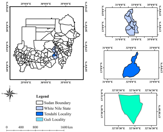
Figure 1. Location of the Study area.
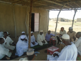
Figure 2. Focus group discussion in Guli locality.
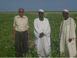
Figure 3. Sesame demonstration farm in Guli locality.
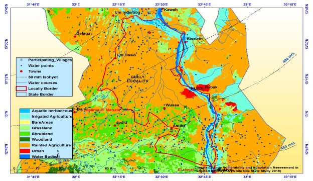
Figure 4. land use map of Gulilocality.
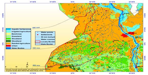
Figure 5. Land use classes in Tendelti locality.
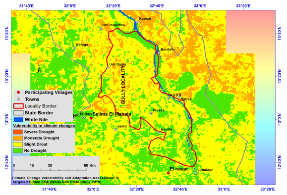
Figure 6. Vulnerability map for Guli locality.
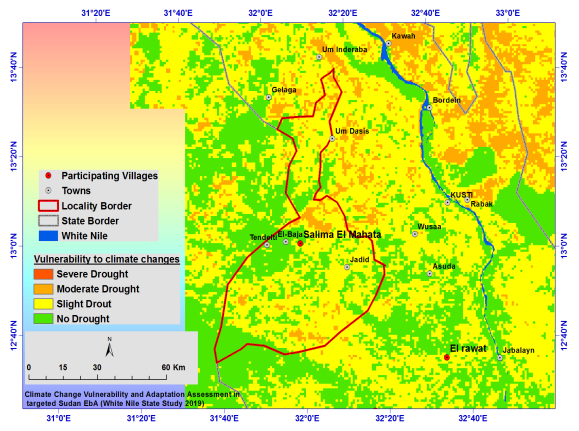
Figure 7. Vulnerability map for Tendelti locality.
Information

