Abstract
This study assesses the positional shift of existing control points and management practices found in and around Assosa town. The static GPS measurement technique was used as an independent source and a point wise method were used to assess the positional shift and accuracy level evaluation. Due to unavailability of local CORS station, two first order GCPs were used as a reference during static GPS measurement. After measurement was conducted depending on the baseline length between control point marks, the STC desktop software and online CSRS-PPP post processing technique was used. Thus, the positional accuracy of selected GCPs of STC Post processing technique has a mean error of 0.324 m and whereas the GCPs of CSRS-PPP has a mean error of 0.571 m. Horizontal distance error obtained with the STC differential technique is ranging from 0 to 0.83 m which is inconsistent relative to the range 0.437 m to 0.815 m obtained from online CSRS-PPP solution. The positional accuracy of GCPs was also assessed using horizontal distance error of both processed techniques. The positional accuracy of GCPs at 95% confidence level is between -0.117 m and 0.765 m with STC and between 0.395 m and 0.747 m in online CSRS-PPP solution. Based on the result, the accuracy level of existing GCPs found in Assosa town, does not meet the FGDC accuracy. This was mainly associated with perception of communities on ground control point management activities. The study revealed almost low communities practice and control point management responsiveness. Finally, study suggested that there should be participatory guidance to establish and manage the ground control points.
Keywords
Control Points, Static GNSS Measurement, Positional Shift, Positional Accuracy, Management Practice
1. Introduction
Land is the source of all economic, political and social activities of humankind. Therefore, using the land in a proper way is very important
| [1] | T. Z. Tadesse Hailu, Engdawork Assefa, “Land use planning implementation and its effect on the ecosystem in Addis,” vol. 13, no. October, 2023. |
[1]
. In order to study the condition and proper uses of natural resource including land, especially in urban areas where land is highly a scarce resource needs surveying applications that have an accuracy range between a few millimeters and a few centimeters
| [2] | FIGURE, CADASTRE 2014 and Beyond Editor, no. 61. 2014. |
[2]
. To conduct an accurate and precise surveying; accurate and dense ground control points are needed, this is because the increasing the distance between the two networked control points causes a decrement in the quality of positions
.
A ground control point is a survey monument usually established with control survey methods as a reference point with known position in terms of longitude, latitude and height or easting, northing and elevation; serving as a reference frame upon which other survey jobs can be justified
| [4] | K. N. Otah, M. A. Emakoji, and M. A. Okono, “ISSN: 3027-169X Ekete - International Journal of Advanced Research Vol. 1 No. 1, Aug. 2023,” vol. 1, no. 1, pp. 19–27, 2023. |
| [5] | A. Miskas and A. Molnar, “Establishing a Reference Network in Parts of Amhara Region, Ethiopia Using Geodetic GPS Equipment,” no. 3117, 2009. |
[4, 5]
. These control points are used as a reference for accurate planning and mapping projects in urban areas, since land use planning and its implementation without accurate control surveying is said to be incomplete. On the historical development of control point’s establishment method (Wolf, 2012, p. 529) states that:
“Traditionally, there have been two general types of control surveys: horizontal and vertical. …. Horizontal control [point] establishment have traditionally been the ground methods of triangulation, precise traversing, trilateration, and combinations of these basic approaches. In addition, astronomical observations were made to determine azimuths, latitudes, and longitudes. Rigorous photogrammetric techniques have also been used to densify the control point in areas”.
Today Global Navigation Satellite System (GNSS) technology plays a very important role, for surveyors and geodesist especially for engineering works, mapping, and several geodetic applications in urban areas. Points made with traditional method in Ethiopia dates more than 50 years back in time and have a poor accuracy, compared to the accuracy that can be achieved with modern technology
| [6] | A. Guidara, G. Fersi, F. Derbel, and M. Ben Jemaa, “ScienceDirect Impacts Impacts of of Temperature Temperature and and Humidity Humidity variations variations on on RSSI RSSI in in indoor indoor Wireless Sensor Networks Wireless Sensor Networks,” vol. 00, 2018. |
[6].
The Global Navigation Satellite System (GNSS) generally provides two techniques, absolute (precise point positioning) and differential (relative) positioning. Highly accurate results can be obtained using differential GNSS (DGNSS). However, there are some limitations in relative GPS technique: two or more receivers are required to be available and the true coordinate of the reference station should be known. Moreover, increasing the distance between the two receivers causes a decrement in the quality of positions
| [7] | S. Timilsina, “Precise Point Positioning (PPP): Method and its Geodetic Usage,” pp. 59–63, 2019. |
[7]
. Due to this fact many studies show that to densify ground control points a new technique in GNSS positioning known as precise point positioning (PPP), a user with a single receiver can attain a positioning accuracy of sub-centimeter and centimeter level in static mode, as compared to differential technique
| [8] | J. C. Liang Li, Chun Jia, Lin Zhao and J. L. and J. Ding, “Real-Time Single Frequency Precise Point Positioning Using SBAS Corrections,” 2016, hppts://dio.org/10.3390/s16081261 |
| [9] | E. Stott and R. D. Williams, “Ground Control Point Distribution for Accurate Kilometre-Scale Topographic Mapping Using an RTK-GNSS Unmanned Aerial Vehicle and SfM Photogrammetry,” pp. 1–21, 2020. |
| [10] | A. Farah, “VARIATION OF STATIC-PPP POSITIONING ACCURACY USING GPS-SINGLE FREQUENCY OBSERVATIONS (ASWAN, EGYPT),” vol. 52, no. 2, 2017, hppts://dio.org/10.1515/arsa-2017-0003 |
[8-10]
.
Precise point positioning technique is preferable whereby, there are no existing ITRF based networks like CORS stations and processing software is unavailable or not suitable
| [11] | Z. Qile, “BDS / GNSS instantaneous centimeter-level Precise Point Positioning (PPP): method and applications,” no. December, 2022. |
| [12] | M. Zahirudin, B. Mohammed, M. Binti, and A. Manaf, “Establishment of control points using GNSS- RTK technique,” vol. 02001, 2024. |
[11, 12]
, based on online processing services, which derive ITRF coordinates or positions, if sufficient RINEX data has been submitted for processing. RINEX, which is an acronym for Receiver Independent Exchange, format. GNSS survey work often has many stations with numerous receiver and antenna combinations from several manufacturers. One of the easiest approaches is to work with the data in a common format
| [2] | FIGURE, CADASTRE 2014 and Beyond Editor, no. 61. 2014. |
[2]
. According to the same fact sheet, PPP provides positioning without the need for a reference station using a single GNSS receiver by using precise satellite orbit and clock corrections.
Establishment of permanent GNSS ground control points and GNSS networks observations as references for other surveying applications should perform with high accuracy
| [13] | P. Jansson, “A Comparison of Different Methods Using GNSS RTK to Establish Control Points in Cadastral Surveying,” 2018. |
| [14] | E. Y. Belay, W. Godah, M. Szelachowska, and R. Tenzer, “ETH – GM21 : A new gravimetric geoid model of Ethiopia developed using the least-squares collocation method Journal of African Earth Sciences ETH – GM21 : A new gravimetric geoid model of Ethiopia developed using the least-squares collocation method,” no. July, pp. 21–22, 2021, hppts://dio.org/10.1016/j.jafrearsci.2021.104313 |
[13, 14]
. To achieve this high accuracy different countries have their own measurement techniques. The most common technique used worldwide is static measurement technique. Which is two or more receivers tracking the same satellite ephemeris simultaneously. The static measurement technique has to be needed baseline post processing, whether in post processing to solve a baseline error between a known reference and unknown station positions differentially or with an online processing technique. The baseline computation is often carried out in the ‘World Geodetic System 1984’ (WGS84) which is a global coordinate system that has to be transformed into local coordinate systems.
There are many web based processing service provider companies worldwide. Among these, this study chooses Canadian Spatial Reference System Precise Point Positioning Service (CSRS-PPP) operated by the Geodetic Survey Division of Natural Resources Canada (NRCan). The researcher chooses this technique; Due to the fact, observational files can be uploaded from the website or through the PPP-Direct desktop software. Additionally, the capability of CSRS-PPP in processing observational data is from 20 minutes to several hours.
Moreover, this research uses an average of a 35-minute observation data (depending on the baseline length), whereas other online processing services need observational data measured at least for 2 hours and above. After post processing, the user receives not only the coordinates and their sigma in the ITRF or NAD83 system, but also diagrams of the visibility of satellites, the temporal convergence of coordinates, the estimated tropospheric delay and clock offset as well as detailed observational data from each measurement epoch. This new method of control point establishment is needed for the countries like Ethiopia, which has sparse geodetic control networks and CORS stations. Especially, in Assosa a town where there are no geodetic networks and the available first order control points accuracy is in doubt.
1.1. Statement of the Problem
In Ethiopia, the greater part of geodetic network was created using conventional triangulation traversing. The points made with a method dates more than 50 years back in time and have a poor accuracy, compared to the accuracy that can be achieved with modern technology
| [6] | A. Guidara, G. Fersi, F. Derbel, and M. Ben Jemaa, “ScienceDirect Impacts Impacts of of Temperature Temperature and and Humidity Humidity variations variations on on RSSI RSSI in in indoor indoor Wireless Sensor Networks Wireless Sensor Networks,” vol. 00, 2018. |
[6]
. The first order controls points exist around Assosa town were established by Ethiopian mapping agency dates more than 29 years ago. Whereas, the second order Ground control points (GCPs) found in Assosa town were established by the Ethiopian Civil Service University 9 years ago by using the first order control points as a reference. Ground control points have accuracy problems in there establishment. The main reason for this is that the method of establishment applied, the equipment used, the quality of reference points has poor accuracy. The reference points that uses to adjust the other established lower order points are not accurate enough, systematic error in the adjusted coordinates would occur. In an increasing urbanization and other competing issues, the control points are reference marks for any infrastructural development in 21th century. Thus, the need of accurate and precise ground control points and management activates is indispensable. Therefore, to establishment of an accurate and well-distributed control network, comparing the positional shift of existing ground control points with static GNSS measurement technique and assessing management perception is the prerequisite and the determinant stage for conducting effective and accurate surveying work. The primary purpose of this research was therefore to assess the positional shift of existing control points and management practices by determining the current positional value of existing control points with static GNSS techniques and rigorously adjust the baseline error in two post-processing techniques. The post processing was performed with south total control (STC) software developed by south survey &mapping instrument CO.LTD (www.southinstrument.com or www.southsurvey.com) and alternatively uses new a technique that is CSRS-PPP online processing service. A comparison between these processing techniques was performed, and the positional difference (coordinate difference between the existing and newly determined coordinate values) of each control point was computed. This study may important for decision makers and surveyors to select the alternative methods and appropriate procedures in the ongoing control point establishment and management endeavors.
1.2. Objectives
The main objective of this research is to assess the positional shift in existing ground control points and management practices in and around Assosa town.
The specific objectives of the study are:
(1). To determine the current positions of ground control points in and around Assosa Town.
(2). To evaluate positional shift by processing first order Known GCPs and online Precise Point Positioning (PPP) in the study area.
(3). To identify communities perceptions to managing control points in Assosa Town.
1.3. Research Questions
1. How many ground control points found in and around Assosa town?
2. Do the ground control points have positional shift (discrepancies) in the study area?
3. How communities perceive on ground control management in the study area?
1.4. Significance of the Study
Assosa town is considered, as one of the fastest growing town in Ethiopia, which is expanding in different directions. This growth and expansion of the city has to be guided with up to date land use plan. Land use planning creates the preconditions required to achieve a type of land use that is environmentally sustainable, socially just and desirable and economically sound. To achieve this, establishing accurate horizontal control networks is a prerequisite to prepare an up-to-date urban plan as well as to implement it. All real state and properties can only be located or staked to the ground based on the survey control points. Although urban land value is increasing time to time, the reliable, up-to-date, complete information about it and other structures are heavily demanding. Therefore, the outcome of this study used as insight for researchers and policy and decision makers. Further, this study used as benchmark for planners and surveyors, and communities to improve their understanding to manage control points.
2. Research Methods and Materials
2.1. Description of the Study Area
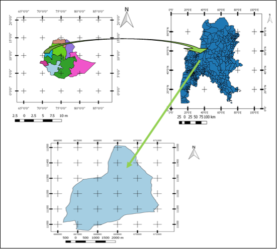
Assosa town is the capital of Benishangul Gumuz Regional State (BGRS), which is one of the nine regional states comprising the Ethiopian federal structure. According to information obtained from the municipality of the town, the town was founded in 1984. It is located in the Southwestern part of the country geographically located between 10°00ꞌ and 10°03ꞌ north and between 34°35ꞌ to 34°39ꞌ east and lies in an area of about 982.5 hectares. In addition, it found 678 km away from Addis Ababa, the capital city of Ethiopia and 90 km away from the Ethio-Sudanese border. We chose Assosa City as a study area because of high demand of land given that the City is the political and economic center of the region; the recorded high rate of urbanization and urban population growth; high level of informal land developments in the peripheries; access to information from government institutions and households has been relatively easy and the possibility to generalize the findings.
Figure 1. Location Map of the Study Area.
2.2. Research Methods
This study was carried out to assess the positional shift in existing control points with static GNSS measurement techniques and management practices in Assosa town. For this study, the researcher applied mixed research design data collection methods. Quantitative data are the data related to the coordinates of GCPs while qualitative data are the data regarding to the management practice of control points.
To achieve the objectives of the study relevant data was collected through a review of literatures and individual interviews from household’s lives around the control points and interviewing key informants, to gather data about the inventory and management of the ground control points found in and around Assosa town. The interview was conducted based on the designed open-ended and closed-ended questions. In addition, data related to the positions of the control points was first obtained from the regional urban development bureau and then GNSS measurement was conducted in static sense with south GNSS receiver, since it was the only available equipment in the study area and finally, the observational data were processed. The processed spreadsheet data and are presented in tables and graphs for comparison. Finally, the data collected from key informant interviews about the management control points were analyzed using descriptive statistics.
2.3. Data Source
To fulfill the aims of the study, the researcher used both primary and secondary data sources. Primary quantitative data sources are the positions of control points (X, Y, Z) of each ground control point, which was collected with static GPS measurement technique and Google earth satellite image of Assosa town. The qualitative data are the data related to the management of control points collected through interviews, key informant interviews and field trips. Secondary data sources data was collected via reading books, reviewing related literatures, standards, manuals and journals. Quantitative data, such as existing ground control point coordinates were obtained from Benishangul Gumuz Region urban development Bureau. Whereas the shape file of Assosa town was obtained from central statistics agency (CSA) data respectively.
2.4. Sampling Technique and Sample Size
In this work, the selected interviewee and key informants were residents near the control points and municipal surveying experts (surveyors) respectively. Purposive non-probability sampling technique was used to select the target sample unit. Given the limited resources, 21 households were purposively selected that GCPs were established near to their fence. Thus, one interviewee in each ground control points was selected for interview. One surveyor at municipal level and one surveyor and an urban planner expert at regional bureau level having knowledge of surveying and planning were selected purposively.
Selections of the measured ground control points were based on the distribution of points through the town. The guidelines of the FGDC, (1998) indicated that “to evaluate the accuracy of control points, at least a minimum of 20 independent ground points shall be examined”. Similarly, American Society for Photogrammetry and Remote Sensing (ASPRS, 2013) developed new Geo-location accuracy standards for digital geospatial data recommends 20 clearly defined checkpoints for a project area of ≤ 500 km2. Accordingly, among 29 GCPs found in the study area, 21 GCPs were selected. In addition, the study uses two first order known control points (namely, “ASOS” and “GCP 4”) out of the town as a reference point. Due to this, the sample GCP points are all 23 available points found in and around the town and their positions were determined using static GNSS post processing techniques for positional shift analysis.
3. Result and Discussion
3.1. Inventory of Ground Control Points in and Around Assosa Town
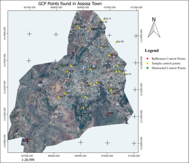
Based on the data found from the urban development bureau, the inventory of the existing control points found in the study area were a total number of 29 established by the Ethiopian Civil Service University as a consultant
Figure A1. Despite 29-ground control points were established 2 years ago, 8 GCPs that accounts 28% of the total do not physically exist now. Four GCPs in the town and another four GCPs out of the plan boundary of the town are not found in their previous station. Ground control points may destructed by different means. According to the socioeconomic data collected from the key informants, Ground Control Point found in Assosa were destructed by the construction of roads, buildings and fences. They also reveal that:
“…. Among eight-destructed GCPs 5 of the GCP, accounts 62.5% of the total were destroyed during the construction of in town road while 1 GCPs which accounts 13% was destructed by the means of building construction. The remaining 2 GCP 25% of the total destructed during fence construction”.
Most of interviewee also emphasized especially on the coordination of different sectors to protect the control points were less. They added that independent institution to take full responsibilities to protect and maintain the control points is not found. As far as the knowledge and observation of the researcher, independent organizational structure is not found to run the surveying and mapping framework at the municipal and regional level. In addition, the site selection during control point establishment was inappropriate. Most of the control points are placed at lots and Block corners of private and public property, on not yet constructed walkways, near to residential house fences and the center of not yet constructed road intersections. Regarding to the protection of control points from destruction, other countries' experience show that, for example, in Seattle city responsibility was assigned to the local jurisdiction to protect the control points by enacting a code of conduct, which states that:
“…..Anyone performing construction, maintenance, or other work in Seattle is responsible for protecting all survey [control points] within the area of work. If it is necessary to disturb a survey monument, a permit must be requested in advance from the Department of Natural Resources. The developer must pay the cost of repairing or replacing the survey monument and is responsible for all contractors working for them”.
Surprisingly in Canada, “There is a large guard Dog watching over survey monuments in Canada. No matter how remote the monuments may be, this brave dog guards them day and night, ready to snarl at anyone who threatens to harm them and bite anyone who does. This fierce, all-seeing beast is sometimes called by its nickname ‘the Criminal Code”. The study found two (2) E.G.I.A first order GCPs located at the Peak of Enzi Mountain (point named ‘ASSOS’) and Abrahamo (GCP 4) (indicated with red triangle). The remaining 25-second order GCPs were found in Assosa town. Among 25 GCPs, 4 of them (green star) do not exist physically. The remaining 21 GCPs (indicated by a yellow circle) are available and used for assessment. Gcp11 and GCP 26 are shown out of the map; this is because of the shape file of the town is not included the place they are found since the GCPs are found in the town’s expansion areas. As shown in
Figure 2.
From these experiences, one can argue that protecting survey control points are a series issue since control points are an asset for both the government and local communities.
3.2. Results of Static GNSS Measurement
3.2.1. Post Processed Results from STC Software
Points named as “ASOS” and “GCP 4” is known control point that used for adjusting the remaining three GCP baselines. All processing solution type is fixed which mean that the baseline is adjusted differentially, the minimum and maximum horizontal root mean square of the network is 0.004, and 0.007 m respectively, that indicates the baseline network adjustment had highly precise (
Table A1).
3.2.2. Results from Online CSRS-PPP Post Processing Technique
The online CSRS-PPP processed results for point ASOS were received via email as a PDF file with a summary. The coordinates after the online post process are expressed in ITRF14 UTM zone 36. To transform these Cartesian coordinates to the Ethiopian national reference system, transformation parameters are used. The transformation from ITRF14 coordinate reference system to ADINDAN UTM ZONE 36N Ethiopian coordinate system had been done with the help of Eye4 Software Hydro-magic Coordinate Calculator. After transformation, there is a difference magnitude of approximately 78 and 206 in x and y position respectively between the two-coordinate systems (
Table A1).
3.3. Positional Shift of Points in Both Processing Methods
A positive and negative sign of numbers shown in (
Table A2), illustrates the magnitude of coordinate shift with respect to easting and noting position. Comparison is made for both methods with respect to deviations in easting and northing component (in meters). The coordinate discrepancy and horizontal distance error results of ASOSA and GCP 4 obtained from STC processed coordinate with respect to existing coordinates shows a zero value. This is because these points are first order GCPs in the study was identified as known control points to adjust other control point positions. Therefore, their coordinate shift and horizontal distance error processing with STC software is also zero that means no adjustment was made for those two points. However, based on online CSRS-PPP processing technique, minimum coordinates discrepancy of 0.207 m, and 0.322 m in x and y position for GCP 7 and ASOS achieved respectively. The maximum discrepancies was archived as 0.609 m and 0.542 m in x and y position for GCP 4. As previously described the first order points were established 29 years back and the researcher could observed that the existing coordinates of this point is equivalent to the coordinates that can be determine with handheld GPS.
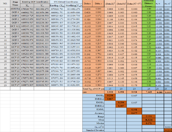
3.4. Statistical Analysis of Results Obtained From STC Software
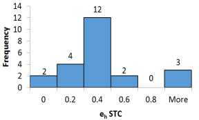
As shown in
Figure A2, research used 23 ground control points for the statistical analysis using south total control software. The horizontal distance error (eh) is expressing the square root of the difference between the coordinate values of the adjusted static GNSS measurement result and existing coordinate values of the same ground control points. The number of GCP points having a horizontal error deviation less than 1 cm are two, the corresponding proportion is 8.7%. Which means that Which means that 21 control points have a deviation exceeding 1 cm: four ground control points have a deviation approximately 0.2 m, which is 17.4% of the total and 12 GCPs has an approximate deviation of 0.4 m that accounts 52.2% and the rest 5 ground control points (21.7%) have a deviation greater than 0.5 m (
Figure 3).
Figure 3. Distribution of horizontal error across the GCP points.
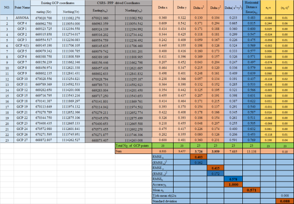
The horizontal root mean square error (RMSEh) value of GCPs was 1.00 m with root mean square error in X (RMSEx) and Y (RMSEy)) dimension value of 0.403 m and 0.415 m respectively. As illustrated in Appendix-2, the mean value of the horizontal distance error (eh) is 0.571 m, the median value is 0.569 m the difference between the mean and the median is 0.002 m, which indicates the distribution of the data is approximately statistically symmetrical. The standard deviation of the horizontal distance error is 0.090 m that shows the coordinates obtained from online CSRS-PP adjustment is somewhat precise. The range of horizontal error is 0.719 m, which is slightly near to the minimum value. The lowest deviation value of horizontal error is 0.437 m.
The skewness is determined to 1.110, which indicates the sample is approximately normally distributed. If an error is normally distributed and independently in each the x- and y-component and error, the factor 1.96 is used to compute horizontal accuracy at the 95% confidence level (section 3.8, equation 9). 𝑀𝑒𝑎𝑛 ℎ𝑜𝑟𝑖𝑧𝑜𝑛𝑡𝑎𝑙 𝑑𝑖𝑠𝑡𝑎𝑛𝑐𝑒 𝑒𝑟𝑟𝑜𝑟 ± 𝜎ℎ ∗ 1. 96 = 0.571 ± 0.090 * 1.96 = 0.571 ± 0.176, which results in a range from 0.395 m to 0.747 m, which is 95% of the horizontal positional uncertainty of the ground control points would fall between 3.95 decimeter to 7.47 decimeter.
3.5. Perception of Households on Managements Status of Control Points
Semi structured questions and a reconnaissance trip were conducted using predetermined open ended and close ended research questions to assess the status and management of existing control points. The interviewee asked questions about information they had on control points, their participation during control point establishment in their respected localities, and about the responsible to protect the control points. As demonstrated in
Table 1, about 90.5% of the total, have no information or awareness about the control points those established in their neighborhood. Only 9.5% of respondents acquired the information from surveyors during establishment by asking surveyors “What are you doing here?” Tried to clarify what they are working along at that place. In again, none of the respondent was taken part during the control point’s establishment work, which clearly indicates that the control point’s establishment work was not participatory. That in turns the households living near to GCPs has less role in the protection of ground control points.
Most of the respondents (57.2%) think that the responsibilities to manage ground control point left for the government only, while 28.6% of respondent expects the local community holds a duty to protect those control points (
Table 1).
Table 1. Households Perception on the management of control stations.Households Perception on the management of control stations.Households Perception on the management of control stations.
No. | Question | Response | Frequency | Percentage |
1 | Awareness on GCPS | Have awareness | 4 | 9.5 |
Haven’t awareness | 17 | 90.5 |
Total | 21 | 100 |
2 | Participation during GCP establishment | Participated | 0 | 0 |
Not Participated | 21 | 100 |
Total | 21 | 100 |
3 | Responsible body to manage survey control stations | The Government | 12 | 57.1 |
Local Communities | 6 | 28.6 |
Every individual | 3 | 14.3 |
Total | 21 | 100 |
Further, the research also observed a situation that the household has heaped woods over the control points, which might break, loosen its paint and labels of control marks constructed with concerts. On the other hand, most of the GCPs were established at inappropriate sites like road centers, close to big fence walls, under large trees etc., which makes them subject to destruction during the construction of different infrastructures. From this, one can argue that it is important that the public be enlightened on the importance of survey control points prior to establishment.
According to the data gathered from key informants reveals that: “The control points found in Assosa town are not sufficiently managed to conduct surveys with total station and other EDM measurement tools, especially in the expansion area, where subdivision survey is needed. Currently we use traditional surveying method by using north direction as a reference and this method is less accurate related to accuracies achieved with using control points as a reference”. Finally, they proved lack of awareness and less community derived counts almost all challenges for control point management.
4. Conclusion
The aim of the study was to conduct assessment on the positional shift of existing ground control points and management practice. Thus, interrelated issues such as inventory, management’s status of corresponding ground control points were assessed. The result shows that the permanency and sustainability of existing ground control points found in Assosa are subject to destruction, since among 29-ground control points, eight GCPs are destroyed within 2 years during the construction of roads, buildings and fences.
The statistical analysis positional shift shows that positional shift of each GCP is ranging from 0 to 0.828 meters in differential processing technique and 0.437 m to 0.815 m in online CSRS-PPP solution. Whereas its level of Accuracy at the 95% confidence level has identified between - 0.117 m to 0.765 m and 0.395 m to 0.747 m in STC and online CSRS-PPP processing techniques respectively. The horizontal accuracies obtained by both processing techniques does not meet the standards set by different departments across the world for the establishment of second order horizontal control points. Accuracy level set by FDGC (1998) at 95% confidence level is 0.046 meter. In addition, (CALTRANS, 2015) also specify 0.02-meter accuracy for second order GCP points which are better than the accuracy range obtained in both processing techniques.
Finally, the study found that there is weak community and concerned body control point management and controlling perceptions. Following this, the study suggests as follows:
1. Ground control points should be considered as an asset of the government and the local community. Therefore, an immediate action should be taken to protect control points found in Asosa town by enacting bylaws, code of conduct.
2. Control point establishment activities should be participatory to the better management of ground control points from destruction.
3. The municipal should update the positions of existing control points prior to using them for future construction survey.
4. There should be good interaction between different users of GCPs jointly for various surveying applications.
Abbreviations
EGIA | Ethiopian Geospatial Information Agency |
GCPs | Ground Control Points |
RMSE | Root Mean Square Error |
CSRS-PPP | Canadian Spatial Reference System Precise Point Positioning Service |
CSA | Central Statistics Agency |
STC | South Total Control |
GNSS | Global Navigation Satellite System |
CORS | Continuously Operating Reference Stations |
DGNSS | Differential Global Navigation Satellite System |
FGDC | Federal Geographic Data Committee |
EDM | Electronic Distance Measurement |
ITRFS | International Terrestrial Reference System |
NAD83 | North American Datum of 1983 |
Author Contributions
Mihret Fentahun Yeneneh: Conceptualization, Resources, Project administration, Data curation, Formal Analysis, Funding acquisition, Investigation, Methodology, Software, Supervision, Validation, Visualization, Writing – review & editing
Gizachew Kassa Addis: Conceptualization, Resources, Data curation, Formal Analysis, Investigation, Methodology, Software, Supervision, Validation, Visualization, Writing – original draft
Teha Romanu Benti: Funding acquisition, Investigation, Project administration, Resources, Software, Supervision, Visualization, Writing – review & editing
Funding
This work is not supported by any external funding.
Data Availability Statement
The data is available from the corresponding author upon reasonable request.
Conflicts of Interest
The authors declare no conflicts of interest.
Appendix
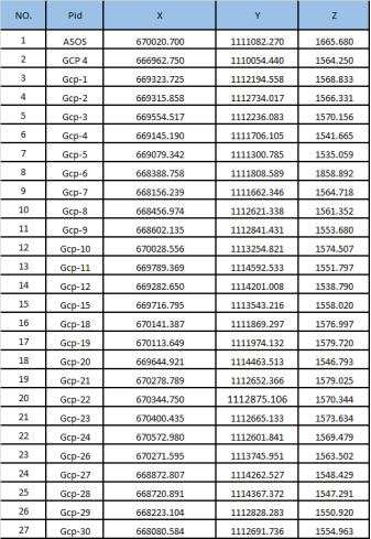
Figure A1. Existing Survey Control Station Coordinates.
Figure A2. Coordinates Derived from STC Software and Statistical Results.
Figure A3. Coordinates Derived from CSRS-PPP and Statistical Results.
Table A1. Processed GNSS Data in Both Techniques.
NO. | Point Name | Coordinates From STC Software | Coordinates From Online CSRS-PPP |
Easting | Northing | Easting | Northing |
1 | ASSOSA | 670020.700 | 1111082.270 | 670021.060 | 1111082.592 |
2 | GCP 4 | 666962.750 | 1110054.000 | 666963.359 | 1110054.542 |
3 | GCP 1 | 669323.628 | 1112194.730 | 669324.139 | 1112194.992 |
4 | GCP 2 | 669316.174 | 1112734.081 | 669316.202 | 1112734.442 |
5 | GCP 3 | 669554.435 | 1112236.293 | 669554.759 | 1112236.492 |
6 | GCP 4(1) | 669145.007 | 1111706.211 | 669145.635 | 1111706.460 |
7 | GCP 5 | 669079.264 | 1111300.862 | 669079.742 | 1111301.201 |
8 | GCP 6 | 668388.589 | 1111808.689 | 668389.169 | 1111808.985 |
9 | GCP 7 | 668156.022 | 1111662.430 | 668156.446 | 1111662.798 |
10 | GCP 8 | 668456.831 | 1112621.569 | 668457.438 | 1112621.685 |
11 | GCP 9 | 668601.945 | 1112841.646 | 668602.633 | 1112841.832 |
12 | GCP 10 | 670028.508 | 1113255.141 | 670028.794 | 1113255.187 |
13 | GCP 11 | 669789.213 | 1114592.930 | 669789.733 | 1114592.923 |
14 | GCP 12 | 669282.892 | 1114201.800 | 669283.004 | 1114201.450 |
15 | GCP 15 | 669716.695 | 1113543.570 | 669717.250 | 1113543.653 |
16 | GCP 18 | 670140.626 | 1111869.601 | 670141.801 | 1111869.761 |
17 | GCP 19 | 670113.636 | 1111974.321 | 670114.042 | 1111974.502 |
18 | GCP 21 | 670278.760 | 1112652.623 | 670279.211 | 1112652.774 |
19 | GCP 22 | 670344.727 | 1112875.393 | 670345.076 | 1112875.499 |
20 | GCP 23 | 670400.429 | 1112665.406 | 670400.653 | 1112665.588 |
21 | GCP 24 | 670572.264 | 1112601.460 | 670573.455 | 1112602.258 |
22 | GCP 26 | 670271.513 | 1113746.324 | 670271.877 | 1113746.306 |
23 | GCP 27 | 668872.594 | 1114262.891 | 668873.407 | 1114263.008 |
Table A2. Positional Shift of Points in Both Processing Methods.
NO. | Point Name | CRCS-ppp | STC | ehcrcs-ppp | ehstc |
Delta X | Delta Y | deltaxe | deltaye |
1 | ASSOSA | 0.360 | 0.322 | 0.000 | 0.000 | 0.483 | 0.000 |
2 | GCP 4 | 0.609 | 0.542 | 0.000 | 0.000 | 0.815 | 0.000 |
3 | GCP 1 | 0.414 | 0.434 | -0.097 | 0.172 | 0.600 | 0.198 |
4 | GCP 2 | 0.344 | 0.425 | 0.316 | 0.064 | 0.547 | 0.322 |
5 | GCP 3 | 0.242 | 0.409 | -0.083 | 0.210 | 0.475 | 0.225 |
6 | GCP 4(1) | 0.445 | 0.355 | -0.183 | 0.106 | 0.569 | 0.212 |
7 | GCP 5 | 0.400 | 0.416 | -0.078 | 0.077 | 0.577 | 0.109 |
8 | GCP 6 | 0.411 | 0.396 | -0.169 | 0.100 | 0.571 | 0.196 |
9 | GCP 7 | 0.207 | 0.452 | -0.217 | 0.084 | 0.497 | 0.233 |
10 | GCP 8 | 0.464 | 0.347 | -0.143 | 0.231 | 0.579 | 0.271 |
11 | GCP 9 | 0.498 | 0.401 | -0.190 | 0.215 | 0.639 | 0.287 |
12 | GCP 10 | 0.238 | 0.366 | -0.048 | 0.320 | 0.437 | 0.324 |
13 | GCP 11 | 0.364 | 0.39 | -0.156 | 0.397 | 0.533 | 0.427 |
14 | GCP 12 | 0.354 | 0.442 | 0.242 | 0.792 | 0.566 | 0.828 |
15 | GCP 15 | 0.455 | 0.437 | -0.100 | 0.354 | 0.631 | 0.368 |
16 | GCP 18 | 0.414 | 0.464 | -0.761 | 0.304 | 0.622 | 0.820 |
17 | GCP 19 | 0.393 | 0.37 | -0.013 | 0.189 | 0.540 | 0.189 |
18 | GCP 21 | 0.422 | 0.408 | -0.029 | 0.257 | 0.587 | 0.259 |
19 | GCP 22 | 0.326 | 0.393 | -0.023 | 0.287 | 0.511 | 0.288 |
20 | GCP 23 | 0.218 | 0.455 | -0.006 | 0.273 | 0.505 | 0.273 |
21 | GCP 24 | 0.475 | 0.417 | -0.716 | -0.381 | 0.632 | 0.811 |
22 | GCP 26 | 0.282 | 0.355 | -0.082 | 0.373 | 0.453 | 0.382 |
23 | GCP 27 | 0.600 | 0.481 | -0.214 | 0.364 | 0.769 | 0.422 |
References
| [1] |
T. Z. Tadesse Hailu, Engdawork Assefa, “Land use planning implementation and its effect on the ecosystem in Addis,” vol. 13, no. October, 2023.
|
| [2] |
FIGURE, CADASTRE 2014 and Beyond Editor, no. 61. 2014.
|
| [3] |
M. Abd-elazeem, A. Farah, and F. A. Farrag, “Geodetic Science Geodetic Science,” vol. 1, no. 3, 2011,
hppts://dio.org/10.2478/v10156-011-0001-3
|
| [4] |
K. N. Otah, M. A. Emakoji, and M. A. Okono, “ISSN: 3027-169X Ekete - International Journal of Advanced Research Vol. 1 No. 1, Aug. 2023,” vol. 1, no. 1, pp. 19–27, 2023.
|
| [5] |
A. Miskas and A. Molnar, “Establishing a Reference Network in Parts of Amhara Region, Ethiopia Using Geodetic GPS Equipment,” no. 3117, 2009.
|
| [6] |
A. Guidara, G. Fersi, F. Derbel, and M. Ben Jemaa, “ScienceDirect Impacts Impacts of of Temperature Temperature and and Humidity Humidity variations variations on on RSSI RSSI in in indoor indoor Wireless Sensor Networks Wireless Sensor Networks,” vol. 00, 2018.
|
| [7] |
S. Timilsina, “Precise Point Positioning (PPP): Method and its Geodetic Usage,” pp. 59–63, 2019.
|
| [8] |
J. C. Liang Li, Chun Jia, Lin Zhao and J. L. and J. Ding, “Real-Time Single Frequency Precise Point Positioning Using SBAS Corrections,” 2016,
hppts://dio.org/10.3390/s16081261
|
| [9] |
E. Stott and R. D. Williams, “Ground Control Point Distribution for Accurate Kilometre-Scale Topographic Mapping Using an RTK-GNSS Unmanned Aerial Vehicle and SfM Photogrammetry,” pp. 1–21, 2020.
|
| [10] |
A. Farah, “VARIATION OF STATIC-PPP POSITIONING ACCURACY USING GPS-SINGLE FREQUENCY OBSERVATIONS (ASWAN, EGYPT),” vol. 52, no. 2, 2017,
hppts://dio.org/10.1515/arsa-2017-0003
|
| [11] |
Z. Qile, “BDS / GNSS instantaneous centimeter-level Precise Point Positioning (PPP): method and applications,” no. December, 2022.
|
| [12] |
M. Zahirudin, B. Mohammed, M. Binti, and A. Manaf, “Establishment of control points using GNSS- RTK technique,” vol. 02001, 2024.
|
| [13] |
P. Jansson, “A Comparison of Different Methods Using GNSS RTK to Establish Control Points in Cadastral Surveying,” 2018.
|
| [14] |
E. Y. Belay, W. Godah, M. Szelachowska, and R. Tenzer, “ETH – GM21 : A new gravimetric geoid model of Ethiopia developed using the least-squares collocation method Journal of African Earth Sciences ETH – GM21 : A new gravimetric geoid model of Ethiopia developed using the least-squares collocation method,” no. July, pp. 21–22, 2021,
hppts://dio.org/10.1016/j.jafrearsci.2021.104313
|
Cite This Article
-
APA Style
Yeneneh, M. F., Addis, G. K., Benti, T. R. (2024). Assessment of Ground Control Points Positional Shift and Management Practices: Evidences from Assosa Town, Western Ethiopia. American Journal of Science, Engineering and Technology, 9(3), 163-174. https://doi.org/10.11648/j.ajset.20240903.12
 Copy
|
Copy
|
 Download
ACS Style
Yeneneh, M. F.; Addis, G. K.; Benti, T. R. Assessment of Ground Control Points Positional Shift and Management Practices: Evidences from Assosa Town, Western Ethiopia. Am. J. Sci. Eng. Technol. 2024, 9(3), 163-174. doi: 10.11648/j.ajset.20240903.12
Copy
|
Download
AMA Style
Yeneneh MF, Addis GK, Benti TR. Assessment of Ground Control Points Positional Shift and Management Practices: Evidences from Assosa Town, Western Ethiopia. Am J Sci Eng Technol. 2024;9(3):163-174. doi: 10.11648/j.ajset.20240903.12
Copy
|
Download
-
@article{10.11648/j.ajset.20240903.12,
  author = {Mihret Fentahun Yeneneh and Gizachew Kassaw Addis and Teha Romanu Benti},
  title = {Assessment of Ground Control Points Positional Shift and Management Practices: Evidences from Assosa Town, Western Ethiopia
},
  journal = {American Journal of Science, Engineering and Technology},
  volume = {9},
  number = {3},
  pages = {163-174},
  doi = {10.11648/j.ajset.20240903.12},
  url = {https://doi.org/10.11648/j.ajset.20240903.12},
  eprint = {https://article.sciencepublishinggroup.com/pdf/10.11648.j.ajset.20240903.12},
  abstract = {This study assesses the positional shift of existing control points and management practices found in and around Assosa town. The static GPS measurement technique was used as an independent source and a point wise method were used to assess the positional shift and accuracy level evaluation. Due to unavailability of local CORS station, two first order GCPs were used as a reference during static GPS measurement. After measurement was conducted depending on the baseline length between control point marks, the STC desktop software and online CSRS-PPP post processing technique was used. Thus, the positional accuracy of selected GCPs of STC Post processing technique has a mean error of 0.324 m and whereas the GCPs of CSRS-PPP has a mean error of 0.571 m. Horizontal distance error obtained with the STC differential technique is ranging from 0 to 0.83 m which is inconsistent relative to the range 0.437 m to 0.815 m obtained from online CSRS-PPP solution. The positional accuracy of GCPs was also assessed using horizontal distance error of both processed techniques. The positional accuracy of GCPs at 95% confidence level is between -0.117 m and 0.765 m with STC and between 0.395 m and 0.747 m in online CSRS-PPP solution. Based on the result, the accuracy level of existing GCPs found in Assosa town, does not meet the FGDC accuracy. This was mainly associated with perception of communities on ground control point management activities. The study revealed almost low communities practice and control point management responsiveness. Finally, study suggested that there should be participatory guidance to establish and manage the ground control points.
},
 year = {2024}
}
Copy
|
Download
-
TY  - JOUR
T1  - Assessment of Ground Control Points Positional Shift and Management Practices: Evidences from Assosa Town, Western Ethiopia

AU  - Mihret Fentahun Yeneneh
AU  - Gizachew Kassaw Addis
AU  - Teha Romanu Benti
Y1  - 2024/09/06
PY  - 2024
N1  - https://doi.org/10.11648/j.ajset.20240903.12
DO  - 10.11648/j.ajset.20240903.12
T2  - American Journal of Science, Engineering and Technology
JF  - American Journal of Science, Engineering and Technology
JO  - American Journal of Science, Engineering and Technology
SP  - 163
EP  - 174
PB  - Science Publishing Group
SN  - 2578-8353
UR  - https://doi.org/10.11648/j.ajset.20240903.12
AB  - This study assesses the positional shift of existing control points and management practices found in and around Assosa town. The static GPS measurement technique was used as an independent source and a point wise method were used to assess the positional shift and accuracy level evaluation. Due to unavailability of local CORS station, two first order GCPs were used as a reference during static GPS measurement. After measurement was conducted depending on the baseline length between control point marks, the STC desktop software and online CSRS-PPP post processing technique was used. Thus, the positional accuracy of selected GCPs of STC Post processing technique has a mean error of 0.324 m and whereas the GCPs of CSRS-PPP has a mean error of 0.571 m. Horizontal distance error obtained with the STC differential technique is ranging from 0 to 0.83 m which is inconsistent relative to the range 0.437 m to 0.815 m obtained from online CSRS-PPP solution. The positional accuracy of GCPs was also assessed using horizontal distance error of both processed techniques. The positional accuracy of GCPs at 95% confidence level is between -0.117 m and 0.765 m with STC and between 0.395 m and 0.747 m in online CSRS-PPP solution. Based on the result, the accuracy level of existing GCPs found in Assosa town, does not meet the FGDC accuracy. This was mainly associated with perception of communities on ground control point management activities. The study revealed almost low communities practice and control point management responsiveness. Finally, study suggested that there should be participatory guidance to establish and manage the ground control points.

VL  - 9
IS  - 3
ER  -
Copy
|
Download