Research Article | | Peer-Reviewed

Current Status of the Vegetation of the South-Western Tenir-too Reserves

Received: 25 February 2025     Accepted: 1 April 2025     Published: 14 April 2025
Views:       Downloads:
Abstract

There are 10 nature reserves in Kyrgyzstan. In 2022, we conducted short-term monitoring of the vegetation cover of the Sary-Chelek Biosphere Reserve and the Besh-Aral State Reserve in Jalal-Abad oblast. The study area is located within the Western Tenir-Too. Species composition of vegetation of the study area is rich. In Jalal-Abad oblast out of 83 Red Data Book species of plants of Kyrgyzstan, 46 species can be found. During the vegetation survey, 7 Red Data Book species of plants of Kyrgyzstan were noted: Abiessemenovii; Amygdalus petunnikowii; Hedysarum chaitocarpum; Malus sieversii; Sorbus persica; Tulipa kaufmanniana and Tulipa anadroma. Sary-Chelek Biosphere Reserve was established in 1959. Besh-Aral State Reserve was established in 1979. The article presents the results of reconnaissance monitoring of vegetation of Besh-Aral State Reserve and Sary-Chelek Biosphere Reserve. According to preliminary data, the vegetation of the reserves is strongly influenced by the complete absence of anthropogenic impact. Monitoring of vegetation cover was carried out in the reserves as well as in the control areas. The vegetation of the control areas is exposed to the effects of grazing. As a result, the species diversity of plant communities decreases, the floral composition is depleted, and a significant part of plant species does not undergo a full vegetation cycle. Overall 13 geobotanical descriptions were compiled indicating the floral composition, abundance, height, phenological phase and vital condition of each plant species. To assess the abundance of plant species, ocular methods of direct accounting on the Drude model were used: cop2 – plants are abundant, cop1 – quite abundant, sp (sparsae) – rare, sol (solitaries) – isolated. The foliage projective cover occupied by projections of the aboveground parts of plants was taken into account for the plant community under study.

Published in American Journal of Life Sciences (Volume 13, Issue 2)
DOI 10.11648/j.ajls.20251302.14
Page(s) 35-45
Creative Commons

This is an Open Access article, distributed under the terms of the Creative Commons Attribution 4.0 International License (http://creativecommons.org/licenses/by/4.0/), which permits unrestricted use, distribution and reproduction in any medium or format, provided the original work is properly cited.

Copyright

Copyright © The Author(s), 2025. Published by Science Publishing Group

Keywords

Key Plot, Control Plot, Total Projective Cover, Abundance, Exposure, Slope Steepness, Community, Flora, Vegetation

1. Introduction
The flora of Western Tenir-Too is one of the richest in mountainous Central Asia both in terms of quantitative composition and diversity and originality of plant species (V.Pavlov, 1980). The Western Tien Shan is one of the unique ecological regions of Central Asia, characterized by the richness, originality of flora, a high degree of concentration of endemic and rare plant species.
The main areas for biodiversity conservation are the five reserves: Sary-Chelek, Padysha-Ata, Besh-Aral (Kyrgyzstan), Chatkal (Uzbekistan) and Aksu-Jabagly (Kazakhstan).
Flora of the region is represented by several thousand species of higher plants, including endemics of the Western Tien Shan, ancestral forms of cultivated fruit plants. The Western Tien-Shan plays a key role in stabilizing the ecological situation in the most difficult by nature and socio-economic situation part of Central Asia. The nearby foothill areas are among the most densely populated in the world. The serious shortage of arable land and irrigation water poses challenges for development in the region.
The investigation of the vegetation of the research area began at the end of the nineteenth century. The vegetation of the Sary-Chelek reserve is best known. The first brief information about vegetation cover of the Sary-Chelek Biosphere Reserve was published in 1896 by S.I.Korzhinsky "Sketches of vegetation of Turkestan". In 1925-1926, the Central Asian Expedition was organized under the leadership of Professor D.N.Kashkarev . The expedition members carried out research on the flora and fauna of the region. D.N.Kashkarev was the initiator of the creation of nature reserves. The research conducted by S. Sokolov , E.Lavrenko and S.Sokolov , N.Rubtsov , H.Borlakov and A. Golovkova and M. Cheremnykh are of especial importance.
The floristic composition of the Besh-Aral reserve's vegetation was studied by G. Lazkov et al. . Tree and shrub vegetation of the Besh-Aral reserve was studied by Sh. Bikirov , according to V. Shikhotov secondary communities prevail in the vegetation cover of the reserve. The primary communities of cereals and cereal-grass meadows have a limited range .
The vegetation of the reserves is very unevenly studied. The vegetation as a dynamic part of the landscape undergoes successional and fluctuational changes. The state of vegetation is influenced by the protected regime and cattle grazing.
From 83 plant species included into the Red Book of the Republic, 46 species are found in Jalal-Abad region. Of these, 7 plant species are found in the study area: Abies semenivii, Amygdalus petunnikiwii, Hedysarum chaitocarpum, Malus sieversii, Sorbus persica, Tulipa anadroma and T. kaufmanniana.
Abies semenivii is a relict endemic of the Western Tien Shan (Figure 1). Fir forests occupy northern and north-eastern slopes in the altitude range 1300-2800 m BS. Limiting factors. Unsystematic felling in the past. Forest fires, overgrazing.
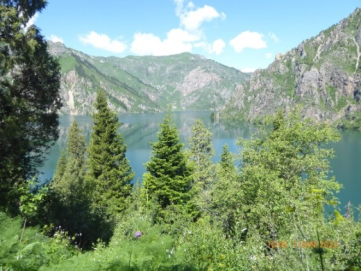
Figure 1. Abies semenovii.JPG.
Amygdalus petunnikiwii (Figure 2) is a narrowly endemic shrub confined to the northern, gravelly slopes of the tree and shrub belt. The limiting factor is overgrazing.
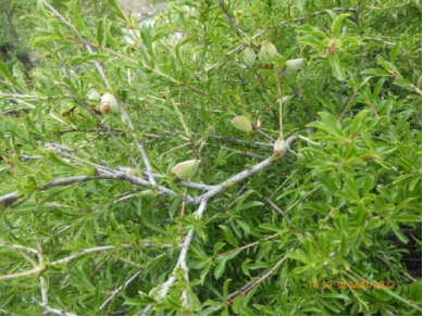
Figure 2. Amygdalus petunnikowii.JPG.
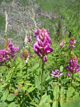
Figure 3. Hedysarum chaitocarpum.JPG.
Hedysarum chaitocarpum (Figure 3) is a relict endemic species of the walnut-fruit forests of the Western Tien Shan. Limiting factors - anthropogenic impact on forests, haymaking.
Malus sieversii (Figures 4 and 5) is distributed in the forest belt in the mountain systems of Central Asia at an altitude from 900 to 2400 m BS. Limiting factors are economic activities, overgrazing. Trees are felled for fuel in a number of habitats and occasionally are severely affected by insect pests.
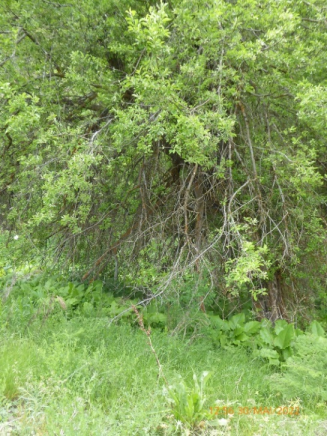
Figure 4. Malus sieversianus.JPG.
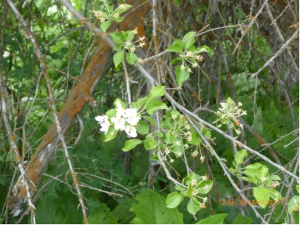
Figure 5. Malus siversianus.JPG.
Sorbus persica (Figure 6) is found in northern Iran, Turkmenistan (Central Kopet Dagh), Pamir-Alai and western Tien Shan. A highly ornamental tree of the forest belt. Limiting factors. Mass felling for craft purposes. Weak regeneration.
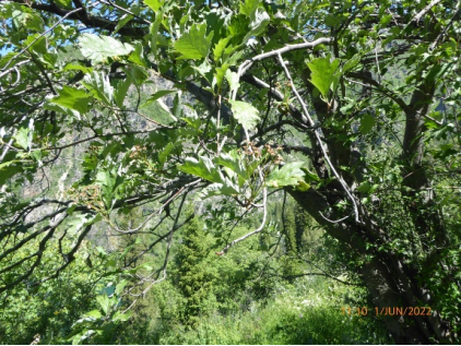
Figure 6. Sorbus persica.JPG.
Tulipa anadroma (Figure 7) endemic species of the Chatkal range with decreasing numbers. The most beautiful of the yellow-flowered tulips of Kyrgyzstan. It is promising for cultivation. Produces on fine-grained and loess-rubbly slopes in walnut forests. Limiting factors. Economical use of forest lands. In protected areas: bulbs are eaten by wild animals in spring and flowers are picked massively.
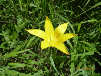
Figure 7. Tulipa anadroma.JPG.
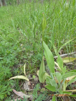
Figure 8. Tulipa kaufmanniana.JP.
T. kaufmanniana (Figure 8) is endemic to the Western Tien Shan. Highly ornamental: the most beautiful, early flowering tulip of Kyrgyzstan. It is characterized by great intraspecific variability. Widely used in breeding. It grows on rocky slopes of the foothills and extends to the middle belt of the mountains. Limiting factors are mass collection of flowers and unregulated grazing.
In the study area, Tulipa anadroma and T. kaufmanniana have survived and are found in high abundance only in nature reserves. The researchers unanimously note that tulips are under enormous anthropogenic pressure, and a thorough study of wild tulip populations is of important scientific and practical importance.
In general, the vegetation cover of the study area is extremely uneven, both in terms of its parts and in terms of communities. Therefore, there is a need for monitoring of vegetation of Besh-Aral and Sary-Chelek nature reserves and adjacent territories.
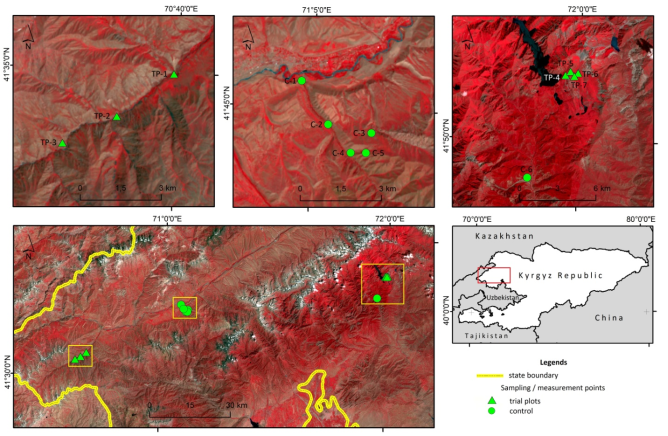
Figure 9. Location of sampling and measurement points (trial plots and control) of vegetations on the slopes of Chatkal mountain range. The background FCC image was created by using Landsat 8 imagery, acquired on 18 July 2022.
2. Materials and Methods
In the summer of 2022 (early June) we started reconnaissance studies of vegetation of Besh-Aral and Sary-Chelek nature reserves in south-western Tenir-Too (Figure 9) in the Ters river basin (Ken-Bulun forestry) and in the Sary-Chelek lake basin. Geobotanical descriptions were made on key plots of 100 m2. In the Ters river basin, Besh-Aral reserve 3 descriptions were made; along the left bank of Chatkal river 5 geobotanical descriptions were made at the control sites, in the Sary-Chelek lake basin one description at the control site and 4 descriptions within the reserve. In total, 6 key sites of the reserves and 7 control sites were used in the work (Table 1). The floristic composition of communities, abundance, height, phenological phase and life state of each species were determined. To assess the abundance of plant species, we used Droude's eye counts on a scale of points. The total projective cover occupied by projections of above-ground plant parts was taken into account for each plant community studied. The monitoring objects were: floristic composition, spatial distribution and condition of plant communities. When laying the key sites, routes for monitoring covered the following plant communities: poplar-grass-broadleaf, shrub-grass-broadleaf, prang-ferruginous, herb-extragon, herb-grass-broadleaf, eremurus-broadleaf, spruce-bush-corton grass, prang-grass-broadleaf and hawthorn-grass-broadleaf.
In the cameral conditions, the species belonging to the herbarium materials of plants were identified and verified. The digital map includes trial plots and control of the phytocenosis of the studied territory. For elaboration of species affiliation of plants was used ‘’Conspectus Florae Asiae Medae’’ . Latin titels were taken from S.K.Cherepanov’s .
3. Results and Discussion
A phytocenological table was compiled as a result of the research. 7 key sites and 6 control sites were mapped. The key plots and controls will be discussed in detail.
For the control plot K#1 corresponds to 1 geobotanical description from the table (Table 1). In the southern part of Kanysh-Kyia village, with geographical coordinates N 41°45'32.4", E 71°04'40.8", on northern gentle slopes, steepness 5-8°, at 1745 m a.s.l. BS. Poplar-grass-grass communities are widespread. The total projective cover of the floodplain forest herbage is 85%. The community is polydominant. Populus talassica is scattered on the background of herb-grass meadows (Table 1). There are different-aged undergrowth of Populus talassica on the area. Hawthorn and rose hips occur sporadically. All plant species underwent a full development cycle and developed normally, including fruiting. Herbaceous vegetation is not affected by grazing.
For the control plot K#2, geobotanical description 2 from the table (Table 1) corresponds. In the second control plot, as in the control plot 1, the vegetation cover is represented by poplar-grass-grass community. The control plot also occupies the northern gentle slopes, 5° steep, with geographical coordinates N 41°44'42.0", E 71°05'27.6", at 1755 m a.s.l. BS. Total projective cover of the herbage is 80%. The tree layer consists of Populus talassica, Hippophae rhamnoides and Salix niedzwiedckii. Lonicera nummulariifolia and Berberis nummularia occur in the shrub layer (Table 1). There is undergrowth of trees and shrubs. All plant species undergo a full development cycle and develop normally, including fruiting. Herbaceous vegetation is not affected by grazing.
The control plot KN#3 corresponds to the 3 geobotanical description from the table (Table 1). Shrub-grass association occurs on western slopes of 25° steepness, with geographical coordinates N 41°44'31.2", E 71°06'36.0" at 1764 m a.s.l. of the base station. Total projective cover of herbage is irregular and varies from 40 to 60%. Shrub vegetation is represented by Spiraea hypericifolia, Rosa sp. and Atraphaxis pyrifolia.
Alyssum dasycarpum dominates. Korolkowia sewerzowii occurs in high abundance. All plant species undergo a full development cycle. Moderate impact of grazing is observed.
For the control plot K#4 corresponds to 4 geobotanical descriptions from the table (Table 1). The shrub-wormwood association occurs on western slopes of 18° steepness, with geographical coordinates N 41°44'09.6", E 71°06'03.6", elevation 1903 m a.s.l. of the base station. Total projective cover of the grass stand is 65%. Shrubs include Amygdalis spinnosissima, Rosa sp. and Cerasus erythrocarpa. Vegetation is intensively grazed in spring, autumn and summer.
For the K5 control plot, the 5 geobotanical descriptions from the table (Table 1) are appropriate. The prangoso-ferulaceous association occupies south-western slopes of 25° steepness, with geographical coordinates N 41°44'09.6", E 71°06'28.8". The elevation of the terrain is 2108 m a.s.l. of the base station. The total projective cover of the grass stand is uneven and amounts to 60%. The dominant communities are Prangos pabularia and Ferula ovina. Amygdalus spinnosissima occurs here occasionally. The vegetation is intensively impacted by grazing.
The key site KU#1 corresponds to the 6 geobotanical descriptions in the table (Table 1). To assess the current state of vegetation in the Ters river basin of the Besh-Aral State Reserve three sites were monitored which are completely free of grazing. The herb-extragon community occupies gentle (5°) southwest slopes, with geographical coordinates N 41°34'58.8", E 70°39'54.0". The elevation of the terrain is 1,620 m a.s.l. of the base station. Total projective cover of the grass stand is uneven - 65%. On the background of herb-extragon association with low abundance there are dominant savannah steppes of Kyrgyzstan - Prangos pabularia and Ferula ovina. Fruiting specimens of the red-listed Kaufmann's tulip are quite common here. All species go through a full developmental cycle and develop normally, including fruiting. Due to the complete lack of exposure to grazing, there is an accumulation of vegetative rags. All plant species develop fully and normally, including fruiting. There is very little decomposition of dead estragon stems. Remains of other grass species decompose in a short time and are fully mineralised.
The key site KU#2 corresponds to the 7 geobotanical description from the table (Table 1). The herbaceous-grass association occupies the middle terrace of the Ters River, gentle southern slopes with a steepness of 5°. The geographical coordinates of the community are N 41°34'04.8", E 70°38'27.6". The elevation of the area is 1673 m a.s.l. BS. Total projective cover of the herbage is 85%. The dominant communities are Poa bulbosa and Artemisia ferganensis. Ferula ovina and Carex turkestanica occur in high abundance. The red-listed Kyrgyz species Amygdalus petunnikowii occurs sporadically. The shrub bears good fruit. There is a small population of Amygdalus petunnikowii in the core area. There is an accumulation of last year's vegetative shoots of boron bluegrass, serpentine alfalfa and tarragon wormwood. Fruiting shoots of Tulipa kaumanniana can be found among the dense herbaceous vegetation. All plant species undergo a full development cycle and develop normally, including fruiting.
Key plot KU#3 corresponds to geobotanical description 8 from the table (fig). The cereal-grass association occupies gentle southern slopes of 10° steepness, with geographical coordinates N 41°33'28.8", E 70°37'01.2". The elevation of the terrain is 1834 m a.s.l. BS. Total projective cover of the grass stand is high - 90%. There is Pyrus regelii. The red-listed species Hedysarum chaitocarpum, Tulipa kaumanniana and Sorbus persica are common here. Of these, the first two species are scattered, while the last one is quite rare. Of the grasses, Poa bulbosa and P. pratensis occur in high abundance. Of the herbs, Salvia deserta, Vicia cracca, Astragalus platyphyllus, etc. are found in high abundance (Table 1).
For the control plot K#6 corresponds to #9 geobotanical description from the table (Table 1). Vegetation monitoring was conducted in the right bank of the Kojo-Ata River in the north-western part of the Arkyt village. Eremurus boradaceus association occupies eastern steep slopes (45°), with geographical coordinates N 41°48'21.6", E 71°57'10.8". The elevation of the terrain is 1303 m a.s.l. BS. Total projective cover of herbage is 50%. Sporadic occurrence of Malus sieversii. Savannah steppe dominant Andropogon ischaemum is severely depressed by grazing. The second dominant species, Eremurus fuscus, has 48 generative shoots out of 100 specimens. The floristic composition of the community is poor. In the plant community, except for Eremurus tanus, narrow-leaved loosestrife, bulbous bluegrass and hop alfalfa have generative shoots. All species of other herbaceous vegetation have no generative shoots. Anthropogenic pressure is due to the fact that the village of Arkyt is located close to the reference area (approximately 500m to the south-east).
For the key site KU#4 corresponds to the 10 geobotanical description from the table (Table 1). Monitoring was conducted in the south-eastern part of Sary-Chelek Lake. Communities of spruce-shrub-shrub association are characteristic and occupy very steep (55°) northern slopes. Geographic coordinates of the community are N 41°52'44.4", E 71°59'42.0". The elevation of the terrain is 1930 m a.s.l. BS. Total projective cover of herbage in glades 75%. Floristic composition of the communities is rich. Tree species: Picia schrenkiana, Abies semenovii and Acer turkestanika are scattered. Of these, Abies semenovii is listed in the Red Data Book. There is a complete absence of beneficial undergrowth and self-seeding tree species. Additional monitoring of tree stand dynamics is required.
The shrub layer is composed of Exochorda tianschanica, Luesiana ulmifolia and Euonimus semenovii. The highly ornamental shrub Exochorda tianschanica is a subendemic. The basis of the grass stand is formed by the short-stemmed forest dwarf. Scattered species of motley grasses occur (Table 1). All species of herbaceous vegetation undergo a full development cycle and develop normally, including fruiting. There is no influence of grazing at all.
Key plot KU#5 corresponds to the 11 geobotanical descriptions from the table (Table 1). The Prangosteum corniculatus association occupies the northern steep slope (40°), with geographical coordinates N 41°52'48.0", E 71°59'09.6". The elevation of the terrain is 2020 m a.s.l. BS. Total projective cover of herbage is high 90%. Floristic composition of the communities is very rich (Table 1). The dominant communities are short-legged woodworm and fodder prangos. The impact of grazing is completely absent.
The key site KU#6 corresponds to the 12 geobotanical descriptions from the table (Table 1). The prangoso-grass association occupies the north-eastern slope with a steepness of 20°. The geographical coordinates of the community are N 41°52'55.2", E 71°59'27.6". The elevation of the area is 2060m a.s.l. BS. Total projective cover of the grass stand is 85%. Apart from the dominant grass, Phleum pratense, Dactylis glomerata occurs in high abundance. The edifier of the communities is Prangos pabularia. The floristic composition of the community is quite rich (Table 1). The endemic, red-listed species Tulipa anadroma occurs sporadically, all individuals have fruiting shoots. Another red-listed species, Hedysarum chaitocarpum, is found here scattered. The plant species comprising the phytocenosis undergo all stages of development and the level of vitality of the plant species is high.
The key site KU#7 corresponds to the 13th geobotanical description from the table (Table 1). The hawthorn-grass-cereal-grass association occupies slopes of eastern exposure with a steepness of 20°. The geographical coordinates of the community are N 41°52'51.6", E 71°59'52.8".The elevation of the area is 1902 m a.s.l. BS. Total projective cover of the herbage is 85%. The tree layer consists of Crataegus sanguinea. Among the grasses, Poa pratensis and Dactylis glomerata occur in high abundance. The species composition of herbs is rather rich (Table 1). The level of plant life is high.
Vegetation is not affected by grazing. According to the Reserve's staff, there are phytophagous ungulates, but there are no traces of herbivores on the site.
Table 1. Phytocenotic indicators of plant communities of the Besh-Aral and Sary-Chelek nature reserves

Geographical coordinates

N 41°45'32.4", E 71°04'40.8"

41°44'42.0", E 71°05'27.6"

N 41°44'31.2", E 71°06'36.0"

N 41°44'09.6", E 71°06'03.6"

N 41°44'09.6", E 71°06'28.8"

N 41°34'58.8", E 70°39'54.0"

Slope exposure

north

north

West

West

Southwestern

Southwestern

Slope steepness

5-8°

25°

18°

25°

Absolute altitude above sea level

1791

1805

1764

1903

2108

1620

General projective coverage

85%

80%

40-60%

65%

35-60%

65%

Description numbers

1

2

3

4

5

6

Site numbers*

К№1

К№2

К№3

К№4

К№5

КU№1

Red Book species of plants:

Abundance of plant species on the Drude scale

1. Abies semenovii

2. Amygdalus petunnikowii

3. Hedysarum chaitocarpum

4. Malus sieversii

5. Sorbus persica

6. Tulipa kaufmanniana

sp

7. Tulipa anadroma

The name of the species

1. Poa bulbosa

sp

sol

sp

sol

Sp3

2. Ferula ovina

sp

Cop 1

Cop 1

sol

3. Potentilla chrysantha

Sp

sp

sp

Sp3

4. Medicago falcata

sp

sp

sp

sp

5. Artemisia dracunculus

sp

sp

sp

Cop 3

6. Prangos pabularia

Cop 1

sol

7. Carex turkestanica

sp

sp

sp

Sp3

8. Vicia cracca

sp

sp

9. Galium verum

sp

sp

sp

10. Dactylis glomerata

sp

11. Taraxacum sp.

Sp

12. Veronica biloba

sp

sol

sol

13. Betonica foliosa

sp

14. Phlomoides sewerzovii

Sp

sp

sp

sp

15. Alcea nudiflora

sol

sol

16. Hieracium robustum

sp

17. Allium aflatunense

18. Poa angustifolia

sp

sp

sol

19. Bromus danthoniae

sp

sp

sp

20. Achillea sp.

sp

sp

21. Poa nemoralis

sp

22. Equisetum arvense

sp

sp

23. Trifolium pratense

sp

sp

24. T. repens

sp

sp

25. Lactuca serriola

Sp

sol

26. Crataegus sanguinea

sol

sol

27. Berberis nummularia

sp

28. Spiraea hypericifolia

Sp-sol

sol

29. Alyssum dasycarpum

Cop 1

sp

sp

30. Viola acutifolia

sol

sol

sol

31. Dipsacus dipsacoides

sp

32. Astragalus platyphyllus

sol

33. Iris albertii

34. Eremurus sp.

35. Ligularia thomsonii

36. Iris ruthenica

37. Origanum tyttanthum

Table 1. Continued.

Geographical coordinates

N 41°34'04.8", E 70°38'27.6"

N 41°33'28.8", E 70°37'01.2"

N 41°48'21.6", E 71°57'10.8"

N 41°52'44.4", E 71°59'42.0"

N 41°52'48.0", E 71°59'09.6"

N 41°52'55.2", E 71°59'27.6"

N 41°52'51.6", E 71°59'52.8"

Slope exposure

south

south

Oriental

north

north

northeastern

Oriental

Slope steepness

10°

45°

55°

40°

20°

20°

Absolute altitude above sea level

1673

1834

1303

1930

2020

2060

1902

General projective coverage

85%

90%

75%

75%

90%

85%

85%

Description numbers

7

8

9

10

11

12

13

Site numbers*

КU№2

КU№3

К№6

КU№4

КU№5

КU№6

КU№7

Red Book species of plants:

Abundance of plant species on the Drude scale

1. Abies semenovii

sol

2. Amygdalus petunnikowii

Un

3. Hedysarum chaitocarpum

sp

sp

4. Malus sieversii

Un

5. Sorbus persica

Un

6. Tulipa kaufmanniana

sp

sol

7. Tulipa anadroma

sp

The name of the species

1. Poa bulbosa

Cop 1

Sp2

Un

2. Ferula ovina

sp

sp

sol

sp

3. Potentilla chrysantha

sp

sol

Sp

4. Medicago falcata

sp

sp

5. Artemisia dracunculus

sp

sp

6. Prangos pabularia

sp

Cop1

Cop 1

sp

7. Carex turkestanica

Cop 1

8. Vicia cracca

sp

sp

Cop 1

9. Galium verum

Sp

sp

10. Dactylis glomerata

sp

sp

sp

11. Taraxacum sp.

sp

sp

sp

12. Veronica biloba

sol

13. Betonica foliosa

sp

sp

sp

14. Phlomoides sewerzovii

15. Alcea nudiflora

sp

sol

16. Hieracium robustum

sol

sol

sp

17. Allium aflatunense

sp

sol

sol

sp

18. Poa angustifolia

19. Bromus danthoniae

20. Achillea sp

sp

21. Poa nemoralis

sp

sp

22. Equisetum arvense

23. Trifolium pratense

sp

24. T. repens

sp

25. Lactuca serriola

sp

26. Crataegus sanguinea

sol

27. Berberis nummularia

sp

Un

28. Spiraea hypericifolia

sp

29. Alyssum dasycarpum

30. Viola acutifolia

31. Dipsacus dipsacoides

sp

sol

32. Astragalus platyphyllus

sol

Sp 3

33. Iris albertii

sp

sp

sp

34. Eremurus sp.

sol

sp

sp

35. Ligularia thomsonii

sp

sp

sp

36. Iris ruthenica

sp

sp

sp

37. Origanum tyttanthum

sp

sp

sp

They are rare: Thalictrum minus – 1, 2; Galium turkestanicum – 1, 2; Pedicularis sp. – 1, 2; Rosa fedschenkoana - 1, 2; Populus talassica 1, 2; Cynoglossum capusii -6, 12; Cousinia umbrosa – 2, 7; Eremurus regelii – 2, 3; Acanthocephalus benthamianus – 3,4; Euphorbia lamprocarpa – 2, 6; Potentilla orientalis – 3, 4; Atraphaxis pyrifolia - 3, 6; Korolkowia sewerzowii – 3, 4; Potentilla canescens – 6, 13; Astragalus lasiosemius - 4, 5; Galium aparine - 3, 13; Eremurus cristatus – 3, 6; Adonis parviflora – 4, 7; Ceratocephala testiculata – 4, 6; Pseudosedum longidentatum – 11, 12; Pedicularis physocalyx – 11,12; Rheum wittroskii – 10, 13; Artemisia ferganensis – 5,8; Hypericum scabrum – 5,6; Scabiosa micranta – 5, 8; Descurainia sophia – 1,5; Ixiolirion tataricum – 6, 8; Ziziphora clinopodioides – 5, 6; Salvia deserta – 6, 8; Eremostachys speciosa – 7, 12; Poa pratensis – 8, 13; Plantago lanceolata – 9, 10; Aegopodium tadshikorum – 9, 12; Convolvulus lineatus – 7, 9; Brachypodium sylvaticum – 10, 11; Viola isopetala – 10, 12; Silene vulgaris – 10, 13; Ulugbekia tschimganica – 10, 11; Geranium albiflorum – 10, 13; Campanula glomerata – 10,12; Polygonum speciosa – 10, 12; Galium boreale – 10, 12; Polygala hybrida – 11, 12; Pedicularis alatavica – 12, 13; Rumex tianschanica – 12, 13; Lamium album – 2, 13; Lonicera tatarica – 7; Betula pendula - 1; Astragalus anisomerus - 1; Phlomoides ebracteolata – 1; Trachelanthus korolkowii – 1; Salix niedzwiedckii – 1; Hippophae turkestanica – 2; Lonicera nummulariifolia - 2; Cerastium cerastoides – 2; Lithospermum officinale – 2; Carex capillaris - 6; Ranunculus polyanthemos -6; Bunium setaceum - 6; Polygonum sp. – 2; Thlaspi kotschyanum - 2; Hieracium virosum - 2; Viola occulta – 2; Gymnospermum alberti – 2; Hesperis sibirica – 2; Cynoglossum greticum - 2; Tauscheria lasiocarpa - 2; Ranunculus acris - 2; Cerastium bungeanum – 2; Cystopteris fragilis – 7; Glycyrrhiza uralensis – 2; Phlomoides pulchra – 6; Papaver litwinowii – 3; Fumaria vaillantii - 3; Leontice incerta - 3; Valerianella coronata - 3; Androsace maxima – 3; Lappula sp. – 3; Bunias orientalis – 3; Artemisia tenuisecta - 4; Silene guntensis - 4; Acantholimon sp. - 4; Solenanthus circinnatus - 4; Cerasus erythrocarpa - 4; Camelina sylvestris – 4; Pseudolinosyris grimmi - 4; Phlomoides brachystegia – 4; Roemeria repracta - 4; Thalictrum isoprpoides – 4; Astragalus nuciferus – 4; Astragalus corydalinus - 6; Dracocephalum nutans - 12; Polygonatum sewerzowii – 12; Oxytropis tschimganica -12; Gentianella tukestanorum – 12; Cerasus tianschanica - 12; Rheum maximowiczii – 13; Onosma irritans -13; Mediasia macrophylla -13; Alyssum campestre - 5; Amygdalis spinnosissima – 4; Lallemanita baldshuranica -5; Phlomoides specoisa – 5; Eryngium macrocalix – 5; Cousinia microcarpa - 5; Potentilla bifurca - 6; Verbascum thapsus – 6; Astragalus sieversianus – 6; Euphorbia talastavica - 12; Cotoneaster integerrimus – 8; Stipa capillata - 6; Petrorhagia alpina - 6; Astragalus schanginianus – 6; Ranunculus liearilobus – 6; Ligularia heterophylla – 6; Biebersteinia multifida – 6; Pyrus regelii – 8; Tragopogon marginifolius -7; Galium pamiroalaicum – 7; Silene obovata – 7; Rosa canina – 9; Euphrasia bajankolica - 9; Carex polyphylla - 9; Ranunculus brevirostris - 9; Convolvulus arvensis - 8; Trollies altaicus – 12; Ferula inciso-serrata - 12; Poygonum alpinum – 9; Paraligusticum discolor – 9; Oxytropis sp. – 7; Draba huetii – 7; Eremostachys isochila -7; Eremurus lactiflorus - 7; Megacarpae orbusculata - 7; Oxytropis pilosissima -7; Astragalus aksaricus - 7; Handelia trichophylla – 7; Eremurus fuscus - 9; Allium sp. - 8; Bothrichloa ischaemum – 9; Salvia sclarea – 9; Medicago lupulina – 9; Sanguisorba officinalis - 9; Tripleurospermum inodorum – 9; Arenaria serpyllifolia – 9; Capsella bursa-pastoris - 9; Picea schrenkiana - 10; Acer turkestanica – 10; Exochorda tianschanica -10; Luesiana ulmifolia - 10; Euonimus semenovii – 10; Codonopsis climatidea – 10; Cicerbita tianschanica – 10; Anemone protracta – 10; Gailum aparine - 10; Atragene sibirica – 10; Impatiens parviflora - 10; Thalictrum foetidum – 10; Asyneuma trautvetteri – 10; Euphorbia jaxartica - 7, 11; Phleum pretense - 12; Phleum pretense – 12; Ranunculus sericeus – 12; Myosotis suaveolensis – 12; Crepis sibirica – 12; Nepeta pannonica -13; Lathyrus pratense a – 13; Antriscus sylvestris – 13.
4. Conclusions
The floristic composition of the study area is rich. A large part of the area is in a protected regime, where there is no impact of grazing. Vegetation of about 45% of the reconnaissance area - key areas (geobotanical descriptions № 6;7;8;11;12;13) are in the protected regime. On the control plots (geobotanical descriptions #1;2;3;4;5;9;10) the vegetation is subjected to different grazing intensity. The reserve regime favourably influences floristic composition of communities, projective cover of herbage, increase of plant abundance and species diversity of phytocenoses.
As a result of the analysis of key and control sites, we found that the conservation regime (no grazing with different duration) favourably affects the floristic composition of communities, the projective cover of herbage, an increase in the abundance of plant species and contributes to the accumulation of plant residues. In general, the current state of vegetation of the reserves was evaluated by us as good.
Vegetation of the control areas is intensively influenced by grazing. As a result, species diversity of plant communities is decreasing and a considerable part of plant species does not pass a complete vegetation cycle (K#6).
Biodiversity, that due to the organization of nature reserves (more than 60 years of Sary-Chelek, more than 40 years of Besh-Aral) the reserve regime maintains the biodiversity of the region.
In the control areas where there are problems, additional monitoring and reduction of grazing pressure is required.
Conflicts of Interest
The authors declare no conflicts of interest.
References
[1] Korzhinsky, S. I. Sketches of vegetation of Turkestan / S. I. Korzhinsky // Zap. imp. of Acad. nauk. - SPb., 1896. - Т. 4, № 4. - С. 1-112.
[2] Kashkarov D. N. Results of the expedition of the Main Museum of Central Asia to the Sary-Chilek Lake area. Kashkarov D. N. Results of the expedition of the Main Central Asian Museum to the region of Lake Sary - Chilek. //Products of the Central Asian Museum, Series VIII, Vol. 2, Tashkent, 1927.
[3] Sokolov S. Ya. Walnut of Southern Kyrgyzstan and variability of its fruits. In: Fruit forests of Southern Kirghizia and their use'. M.-L. Publishing house of AS USSR, 1949.
[4] Sokolov S. Ya., Lavrenko E. M. Botanical research of Southern Kirghiz expedition of 1944 of the Academy of Sciences of the USSR // Sov. botanika. Т. 13, № 3. С. 71-72.
[5] Rubtsov N. I. Mountain fruit forests and mountain shrubs. "Plant cover of the USSR". Moscow-L. Publishing House of Academy of Sciences of USSR, 1956.
[6] Borlakov H. U., Golovkova A. G. Vegetation of Sary-Chelek reserve. Issue IV. Frunze, 1971. - 99 с.
[7] Cheremnykh M. A. Vegetation of the Sary-Chelek reserve. - Bratsk, 1995. -257 с.
[8] Lazkov G. A., Sultanova B. A., Kenzhebaeva N. V. Degree of study of flora of Western Tien-Shan within Kyrgyzstan and centres of its local endemism. State and prospects. Bishkek. 2002. С. 170-175.
[9] Bikirov Sh. B. Species composition of forest vegetation of Besh-Aral reserve. State and prospects. Bishkek. 2002. С. 27-31.
[10] Kendirbaeva A. J., Shalpykov K. T., Rogova N. A., Dolotbakov A. K., Usen u. Chyngyz The state of wild tulips on the northern macro-slope of the Kyrgyz Ala-Too in relation to the problem of their extinction. Arid Ecosystems, 2022, Vol. 24, No. 4(77), pp. 60-66. 60-66.
[11] A critical synopsis of the flora of Central Asia, vol. A critical outline of the flora of Central Asia, vol. I. Tashkent, 1968; vol. 1971; vol. III. 1972; vol. IV/ 1974; vol. 1976; vol. VI. 1981; vol. VII. 1983; vol. VIII. 1986; vol. IX. 1987; vol. X. 1993.
[12] Red Data Book of the Kyrgyz Republic. Bishkek. 2006. -544 с.
[13] Shikhotov V. M. Anthropogenic changes in vegetation cover of Besh-Aral reserve and forecast of its further state. // Biodiversity of Western Tien-Shan. State and prospects. Bishkek. 2002. С. 286-288.
[14] Cherepanov S. K. Vascular plants of Russia and neighbouring countries (within the former USSR). - 2nd ed. - St. Petersburg, 1995. - 990 с.
Cite This Article
  • APA Style

    Kendirbaeva, A., Toktorova, R., Westermeier, T., Totubaeva, N., Zholdoshbekov, E., et al. (2025). Current Status of the Vegetation of the South-Western Tenir-too Reserves. American Journal of Life Sciences, 13(2), 35-45. https://doi.org/10.11648/j.ajls.20251302.14

    Copy | Download

    ACS Style

    Kendirbaeva, A.; Toktorova, R.; Westermeier, T.; Totubaeva, N.; Zholdoshbekov, E., et al. Current Status of the Vegetation of the South-Western Tenir-too Reserves. Am. J. Life Sci. 2025, 13(2), 35-45. doi: 10.11648/j.ajls.20251302.14

    Copy | Download

    AMA Style

    Kendirbaeva A, Toktorova R, Westermeier T, Totubaeva N, Zholdoshbekov E, et al. Current Status of the Vegetation of the South-Western Tenir-too Reserves. Am J Life Sci. 2025;13(2):35-45. doi: 10.11648/j.ajls.20251302.14

    Copy | Download

  • @article{10.11648/j.ajls.20251302.14,
      author = {Almagul Kendirbaeva and Ryskul Toktorova and Teresa Westermeier and Nurzat Totubaeva and Emilbek Zholdoshbekov and Gulmira Bazarova and Mihai Voda},
      title = {Current Status of the Vegetation of the South-Western Tenir-too Reserves
    },
      journal = {American Journal of Life Sciences},
      volume = {13},
      number = {2},
      pages = {35-45},
      doi = {10.11648/j.ajls.20251302.14},
      url = {https://doi.org/10.11648/j.ajls.20251302.14},
      eprint = {https://article.sciencepublishinggroup.com/pdf/10.11648.j.ajls.20251302.14},
      abstract = {There are 10 nature reserves in Kyrgyzstan. In 2022, we conducted short-term monitoring of the vegetation cover of the Sary-Chelek Biosphere Reserve and the Besh-Aral State Reserve in Jalal-Abad oblast. The study area is located within the Western Tenir-Too. Species composition of vegetation of the study area is rich. In Jalal-Abad oblast out of 83 Red Data Book species of plants of Kyrgyzstan, 46 species can be found. During the vegetation survey, 7 Red Data Book species of plants of Kyrgyzstan were noted: Abiessemenovii; Amygdalus petunnikowii; Hedysarum chaitocarpum; Malus sieversii; Sorbus persica; Tulipa kaufmanniana and Tulipa anadroma. Sary-Chelek Biosphere Reserve was established in 1959. Besh-Aral State Reserve was established in 1979. The article presents the results of reconnaissance monitoring of vegetation of Besh-Aral State Reserve and Sary-Chelek Biosphere Reserve. According to preliminary data, the vegetation of the reserves is strongly influenced by the complete absence of anthropogenic impact. Monitoring of vegetation cover was carried out in the reserves as well as in the control areas. The vegetation of the control areas is exposed to the effects of grazing. As a result, the species diversity of plant communities decreases, the floral composition is depleted, and a significant part of plant species does not undergo a full vegetation cycle. Overall 13 geobotanical descriptions were compiled indicating the floral composition, abundance, height, phenological phase and vital condition of each plant species. To assess the abundance of plant species, ocular methods of direct accounting on the Drude model were used: cop2 – plants are abundant, cop1 – quite abundant, sp (sparsae) – rare, sol (solitaries) – isolated. The foliage projective cover occupied by projections of the aboveground parts of plants was taken into account for the plant community under study.
    },
     year = {2025}
    }
    

    Copy | Download

  • TY  - JOUR
    T1  - Current Status of the Vegetation of the South-Western Tenir-too Reserves
    
    AU  - Almagul Kendirbaeva
    AU  - Ryskul Toktorova
    AU  - Teresa Westermeier
    AU  - Nurzat Totubaeva
    AU  - Emilbek Zholdoshbekov
    AU  - Gulmira Bazarova
    AU  - Mihai Voda
    Y1  - 2025/04/14
    PY  - 2025
    N1  - https://doi.org/10.11648/j.ajls.20251302.14
    DO  - 10.11648/j.ajls.20251302.14
    T2  - American Journal of Life Sciences
    JF  - American Journal of Life Sciences
    JO  - American Journal of Life Sciences
    SP  - 35
    EP  - 45
    PB  - Science Publishing Group
    SN  - 2328-5737
    UR  - https://doi.org/10.11648/j.ajls.20251302.14
    AB  - There are 10 nature reserves in Kyrgyzstan. In 2022, we conducted short-term monitoring of the vegetation cover of the Sary-Chelek Biosphere Reserve and the Besh-Aral State Reserve in Jalal-Abad oblast. The study area is located within the Western Tenir-Too. Species composition of vegetation of the study area is rich. In Jalal-Abad oblast out of 83 Red Data Book species of plants of Kyrgyzstan, 46 species can be found. During the vegetation survey, 7 Red Data Book species of plants of Kyrgyzstan were noted: Abiessemenovii; Amygdalus petunnikowii; Hedysarum chaitocarpum; Malus sieversii; Sorbus persica; Tulipa kaufmanniana and Tulipa anadroma. Sary-Chelek Biosphere Reserve was established in 1959. Besh-Aral State Reserve was established in 1979. The article presents the results of reconnaissance monitoring of vegetation of Besh-Aral State Reserve and Sary-Chelek Biosphere Reserve. According to preliminary data, the vegetation of the reserves is strongly influenced by the complete absence of anthropogenic impact. Monitoring of vegetation cover was carried out in the reserves as well as in the control areas. The vegetation of the control areas is exposed to the effects of grazing. As a result, the species diversity of plant communities decreases, the floral composition is depleted, and a significant part of plant species does not undergo a full vegetation cycle. Overall 13 geobotanical descriptions were compiled indicating the floral composition, abundance, height, phenological phase and vital condition of each plant species. To assess the abundance of plant species, ocular methods of direct accounting on the Drude model were used: cop2 – plants are abundant, cop1 – quite abundant, sp (sparsae) – rare, sol (solitaries) – isolated. The foliage projective cover occupied by projections of the aboveground parts of plants was taken into account for the plant community under study.
    
    VL  - 13
    IS  - 2
    ER  - 

    Copy | Download

Author Information